This item has been sold, but you can get on the Waitlist to be notified if another example becomes available, or purchase a digital scan.
1960 Rand McNally Pictorial Road Map of Florida
Florida-randmcnally-1960$150.00

Title
Florida.
1960 (undated) 40 x 18 in (101.6 x 45.72 cm) 1 : 729000
1960 (undated) 40 x 18 in (101.6 x 45.72 cm) 1 : 729000
Description
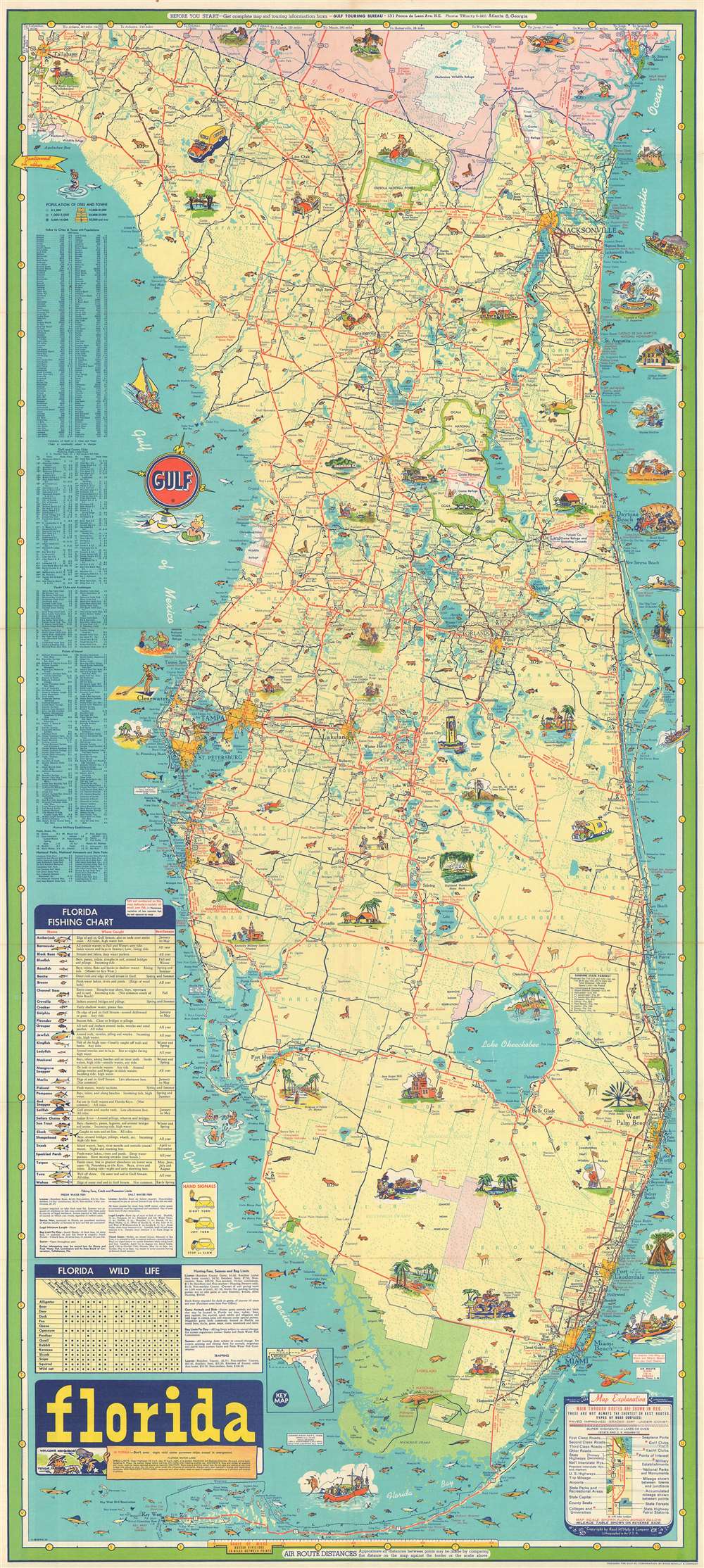
This is a c. 1960 Rand McNally pictorial road map of Florida. The map depicts the region from Tallahassee to the Atlantic Ocean and from Georgia to the Florida Keys. Comical vignettes are interspersed throughout the state, illustrating sites from Tallahassee to the Keys. Florida State University is highlighted, as is the Fountain of Youth in St. Augustine, the band shell in Daytona Beach, the Singing Tower at the Singing Tower and Mountain Lake Sanctuary. Other vignettes highlight Sanlando Springs near Orlando, the Brevard Bird Reserve, Turtle Mound State Monument, the Avenue of Palms in Fort Myers, the University of Miami in Coral Gables, and the University of Tampa in Tampa. Cities and towns from Tallahassee to Miami are illustrated and labeled as well, including Tampa, St. Petersburg, Orlando, Jacksonville, Tallahassee, Miami, Miami Beach, and Fort Lauderdale.
Everglades National Park in southern Florida is shaded green and is illustrated by a very happily sleeping alligator and a small illustration of a puma. Small illustrations of Florida wildlife are scattered all across the state, and nineteen different species of fish native to Florida's coasts are noted as well. Each species is even numbered and corresponds to a fishing chart situated along the left border which names all nineteen species, where they are caught, and the best time of year to catch each one. Indexes of cities, golf and country clubs, yacht clubs and anchorages, points of interest, active military establishments, national parks, national monuments, and state parks are also included along the left border. A key in the lower right corner explains the various notations used on the map.
Everglades National Park in southern Florida is shaded green and is illustrated by a very happily sleeping alligator and a small illustration of a puma. Small illustrations of Florida wildlife are scattered all across the state, and nineteen different species of fish native to Florida's coasts are noted as well. Each species is even numbered and corresponds to a fishing chart situated along the left border which names all nineteen species, where they are caught, and the best time of year to catch each one. Indexes of cities, golf and country clubs, yacht clubs and anchorages, points of interest, active military establishments, national parks, national monuments, and state parks are also included along the left border. A key in the lower right corner explains the various notations used on the map.
Publication History
This map was created by Rand McNally and published by the Gulf Oil Company c. 1960.Cartographer
Rand, McNally and Co. (fl. 1856 - present) is an American publisher of maps, atlases and globes. The company was founded in 1856 when William H. Rand, a native of Quincy, Massachusetts, opened a print shop in Chicago. Rand hired the recent Irish immigrant Andrew McNally to assist in the shop giving him a wage of 9 USD per week. The duo landed several important contracts, including the Tribune's (later renamed the Chicago Tribune) printing operation. In 1872, Rand McNally produced its first map, a railroad guide, using a new cost effective printing technique known as wax process engraving. As Chicago developed as a railway hub, the Rand firm, now incorporated as Rand McNally, began producing a wide array of railroad maps and guides. Over time, the firm expanded into atlases, globes, educational material, and general literature. By embracing the wax engraving process, Rand McNally was able to dominate the map and atlas market, pushing more traditional American lithographic publishers like Colton, Johnson, and Mitchell out of business. Eventually Rand McNally opened an annex office in New York City headed by Caleb S. Hammond, whose name is today synonymous with maps and atlases, and who later started his own map company, C. S. Hammond & Co. Both firms remain in business. More by this mapmaker...
Condition
Very good. Even overall toning. Light wear along original fold lines. Verso repair to fold separation. Closed margin tear professionally repaired on verso. Map of western Florida and the southeastern United States on verso.