This item has been sold, but you can get on the Waitlist to be notified if another example becomes available, or purchase a digital scan.
1854 Surveyor General Wescott Map of Florida
Florida-wescott-1854$250.00

Title
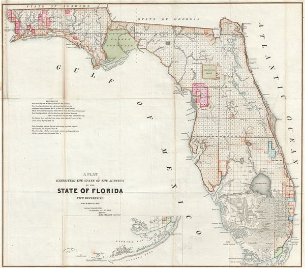
A Plat Exhibiting the State of the Surveys in the State of Florida with References.
1854 (dated) 25 x 27 in (63.5 x 68.58 cm) 1 : 1140480
1854 (dated) 25 x 27 in (63.5 x 68.58 cm) 1 : 1140480
Description
An exceptional example of the 1854 Land Survey Map of Florida. This map represents the state of the Land Survey in Florida as of October 1854. Shows the state divided into several hundred numbered plats, some of which are marked with an 'S' to state that they had been fully surveyed, and some with a 'T' suggesting that they had only been surveyed externally. The map labels several important Seminole War Forts including Fort Bassinger, Fort Center, Fort Thompson, Fort Beynaud, Fort Adams, and others. Notes the everglades, Big Cypress, Fort Lauderdale, Lake Okeechobee, and many of FloridaÂ's lakes and river systems.
Also shows both the Arrendondo Grant and Forbes Purchase. Arredondo Grant is a layover of the Spanish Land Grant program, which bequeathed it to a powerful Spanish merchant - Arrendondo. With incredible difficulty and protest, the land grants were dissolved when Florida became part of the United States. Forbes Purchase refers to a large tract of land in the Florida Panhandle that was purchased from Spain by three American traders in the late 18th century. After Florida became part of the United States there was an attempt by the government to seize this land, but it was shot down by the United States Supreme Court. Unfortunately, as Forbes Purchase was mostly uninhabitable swampland, it was impossible to develop and later sold off in lots.
The map is dated to 1854 and attributed John Wescott, Florida Surveyor General. Wescott took the office of Florida Surveyor General in 1853. He is known to have issued three maps of Florida to accompany his annual reports - this is the second and represents a major update adding an inset of the Florida Keys. Although there is no imprint, it was most likley was printed by the Washington D.C. firm A. Hoen and Company.
CartographerS
The General Land Office (1812 - 1946) was an independent agency charged with the administration and sale of public lands of the western territories of the United States under the Preemption Act of 1841 and the Homestead Act of 1862. During a time of frenetic energy and rapid westward expansion, the Land Office oversaw the surveying, platting, mapping and eventually the sale of much of the Western United States and Florida. The structural layout of the western United States that we see today, and many of their district and county divisions, are direct result of the early surveying work of the General Land Office. More importantly, as a branch of the Federal Government in Washington D.C. and the only agency able to legally sell and administer public lands in the western territories of the United States, the General Land Office played a pivotal role in consolidating power away from the original states and into the hands of the centralized federal government. The General Land Office was absorbed into the Department of Interior in 1849 and in 1946 merged with the United States Grazing Service to become the Bureau of Land Management. Today the Bureau of Land Management administers the roughly 246 million acres of public land remaining under federal ownership. More by this mapmaker...
August Hoen and Company (fl. c. 1840 - 1981) was a Baltimore based engraving and lithography firm active in the middle part of the 19th century. A. Hoen and Co. was originally founded by Edward Weber under the name 'E. Weber and Company.' Weber died in the early 1850s and his company was taken over by German immigrant August Hoen (18?? - 1886) and his brothers, Henry and Ernest Hoen. As general interest lithographers, the Hoen firm's corpus includes posters, cigar boxes, sheet music covers, and posters as well as maps. They are best known for their pioneering multi-color lithographic techniques. After the death of August Hoen, the business passed on to his son, Albert Hoen. Another son, Earnest A. Hoen, moved to Richmond, Virginia and opened a branch of the firm there where he was granted a charter to produce Civil War era Confederate Currency. Their contributions to the cartographic field are generally in association with engraving and printing work done for Jacob Monk and the U.S. Geological Survey. The Hoen family maintained an active interest in the firm for the next 100 years or so until it finally filed for bankruptcy in 1981. Learn More...
Source
Maps and Views to Accompany Message and Documents 1855-56, (Washington: Nicholson) 1856.
Condition
Very good. Original fold lines visible. Minor discoloration over fold lines. Blank on verso. Professionally flattened and backed with archival Japanese tissue.
References
Servies, J. A. , A Bibliography of West Florida, #3097. Phillips (America) p. 284.