1807 Direccion Hidrografia Nautical Chart or Map of Florida and Bahamas
FloridaBahamas-direccionhidrografia-1807$5,000.00


Title
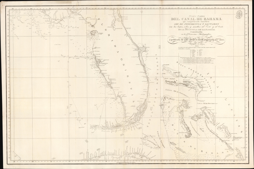
Nueva Carta del Canal de Bahama que comprehende tambien Los de Providencia y Santaren con los bajos, islas, y sondas al Este y al Oeste de la Peninsula de la Florida...
1807 (undated) 24 x 36 in (60.96 x 91.44 cm) 1 : 150000
1807 (undated) 24 x 36 in (60.96 x 91.44 cm) 1 : 150000
Description
A strikingly engraved 1807 Spanish nautical map of Florida and the Bahamas (Lucayas) published in Madrid by the Spanish Dirección Hidrografía. It is among the earliest modern nautical charts to focus specifically on Florida and was based on the 1799 observations of Dionisio Alcalá Galiano (1760 - 1805) aboard the ship San Fulgencio.
This map is scarce in all editions, but early states are particularly uncommon.
A Closer Look
Coverage extends roughly from St. Augustine to Cuba and from the Bay of St. Andres (Saint Andrew Bay) to Rum Cay and I. Conception. There is very little inland detail, but the Florida Keys, Tampa Bay, and Biscayne Bay are well mapped, with notes identifying freshwater sources. The general shape of Florida is consistent with maps of the period, including an exaggerated hook south of Cape Romano and an unexplored region in the vicinity of the Suwanee River and Cedar Key.Historical Context
In 1807, Florida was still Spanish territory, although little understood and sparsely populated. As they were increasingly driven out of traditional homelands further north, various American Indian groups were slowly filtering into central Florida, beginning the ethnogenesis of the Seminole nation. The Spanish were active further north in St. Augustine but had little inland commerce, relying on ranching, fishing, and some frontier trade. West Florida remained little known, except Tampa and Fort Meyers Bays, which were known havens against foul weather conditions in the Gulf of Mexico.State of Muskogee
There is a blank area on the map in the vicinity of Cedar Key, here named 'I. Savinas'. In 1799, William Augustus Bowles (1763 - 1805), a Loyalist veteran of the American Revolutionary War, attempted to unite American Indians living in the Southeastern United States into a breakaway republic allied with the British, the State of Muskogee. He based himself in the Indian town of Miccosukee, also known as Mikasuki, on Lake Miccosukee, northeast of present-day Tallahassee, from which he conducted raids on American settlements, including Fort Marcos. He also constructed a watchtower on Cedar Key, which a Spanish naval expedition burned to the ground in 1802 - hence the mapping here of Cedar Key, while all surrounding areas remained unexplored.Publication History and Census
This map was drafted for publication by the Dirección Hidrografía by Miguel Moreno and engraved by Ferdinand Selma. The lettering was engraved by Morata. This map was first issued in 1805. The present example represents the 1807 second edition and bears significant hydrographic updates, mostly in the Bahamas. It served as the basis of European maritime mapping in and around Florida well into the mid-19th century.This map is scarce in all editions, but early states are particularly uncommon.
CartographerS
The Direccion Hidrografía (1787 - 1927), also known as the Deposito Hydrografico and the Direction de Hidrografía, was the Spanish equivalent of the British Admiralty or the U.S. Coast Survey. This organization, founded in 1787, was commissioned to collect and produce accurate nautical charts of all waters frequented by Spanish vessels. In essence, it replaced the Casa de la Contratación de las Indias (House of Trade of the Indies), which closed its doors in 1790. Like most such organizations, the Direccion Hidrografía marked a new age in cartography. Rather than simply collect charts created by navigators, explorers, and merchants, the Direccion Hidrografía worked closely with naval and military personnel to mount cartographic and hydrographic expeditions in pursuit of the most accurate hydrographical, astronomical, and geodetic measurements. The Direccion Hidrografía created a massive library of nautical charts that, though not nearly as common as similar nautical charts by the U.S. Coast Survey and British Admiralty, are highly desirable for the beauty of their manufacture as well as their accuracy and detail. The office was originally located on Calle Ballesta, but relocated to 36 Alcala, both in Madrid. After 1908 the Dirección was subsumed into other governmental agencies. In 1927 the Direccion was absorbed into the Institute and Observatory of San Fernando, located in Cadiz. The library of original maps, charts, and journals was transferred to the Naval Museum of Madrid - where it resides to this day. More by this mapmaker...
Clemente Noguera (fl. c. 1809 – 1860) was a Spanish draftsman, naval pilot, and engraver based in Madrid during the middle part of the 19th century. Little is known of Noguera, but he was active as an engraver as early as 1809, when he engraved a plan of Zaragoza, Spain. He was a second lieutenant of the Spanish Navy in 1830. By, 1850, Noguera was a senior draftsman for the Direccion de Hidrografia. Clemente Noguera should not be confused with Juan Noguera, who was also a senior line-engraver at the Direccion de Hidrografia. The two engravers may or may not be related. Clemente was significantly older than Juan, and may have been an older relative. Learn More...
José Espejo Y Carré (fl. c. 1829 - 1857) was a Spanish sea captain, naval officer, navigator, and draftsman active in Madrid during the middle part of the 19th century. He may have been stationed in Cartagena as early as 1829. Espejo is identified in 1852 a Senior Draftsman with the Dirección Hidrografía. Learn More...
Manuel Giraldos (fl. c. 1830 - 1850) was a copper and line and letter engraver active in Madrid during the early to middle parts of the 19th century. Giraldos studied engraving under José Asensio. He worked extensively as a letter engraver for the Dirección Hidrografía. Learn More...
Condition
Very good. Minor margin reinforcements and repairs - but none even close to the printed map. Very slight foxing and near-invisible dampstain upper left corner. Pencil marks track route along the coast of Florida to Havana.
References
OCLC 1025903043. Tampa Bay History Center, Touchton Map Library, #M1510 (1805 edition).