This item has been sold, but you can get on the Waitlist to be notified if another example becomes available, or purchase a digital scan.
1838 Direccion Hidrografia Nautical Chart or Map of Florida and Bahamas
FloridaBahamas-direccionhidrografia-1838-2$2,000.00

Title
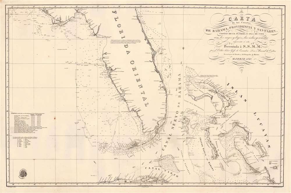
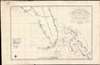
Carta de los Canales de Bahama, Providencia y Santaren, Costas de la Florida e Isla de Cuba con los cayos y bajos, las islas y sondas adyacentes a esta...
1838 (undated) 24 x 36 in (60.96 x 91.44 cm) 1 : 150000
1838 (undated) 24 x 36 in (60.96 x 91.44 cm) 1 : 150000
Description
A strikingly engraved 1838 Spanish nautical chart of Florida and the Bahamas (Lucayas) published in Madrid by the Spanish Dirección Hidrografía. Coverage extends roughly from St. Augustine to Cuba, and from the Bay of St. Andres (Saint Andrew Bay) to Rum Cay and I. Conception. There is very little inland detail, but the Florida Keys, Tampa Bay, and Biscayne Bay are well mapped - with notes identifying water sources. The routes of several voyages influential in preparing the map are noted, for the most part, undertaken between 1794 and 1820. The Cape Florida lighthouse near Miami, constructed in 1825, is also noted. The general shape of Florida is consistent with maps of the period, including an exaggerated hook south of Cape Romano, and an unexplored region in the vicinity of the Crystal River south of the Cedar Keys. Pencil marks track the map's use on a single voyage, from Cadiz (Spain) to Havana.
This map is scarce. We have identified 4 instances of it appearing on the market, and only once (through us) in the last 10 years. It is present in 6 institutional collections, most in poor condition: the Tampa Bay History Center, the Madrid AECID Library, the Museu Marítim de Barcelona (MMB), the Basque Museum of Bilbao, the Biblioteca de Catalunya, and Duke University.
Historical Context
A little more than a decade earlier, through 1819 Adams-Onís Treaty, Spain surrendered Florida (and Oregon) to the United States. The vast swampy territory was nonetheless only tenuously explored and presumably of little economic value - instead, the U.S. considered the acquisition of Florida in a strategic context, thus securing all of the North American mainland east of Texas and south of Canada. Major development in Florida would not happen until after the American Civil War (1861 - 1865).Publication History and Census
This map was drafted for publication by the Dirección Hidrografía by José Espejo Y Carré and engraved by Clemente Noguera. The lettering was engraved by Manuel Giraldos. We are aware of only one edition.This map is scarce. We have identified 4 instances of it appearing on the market, and only once (through us) in the last 10 years. It is present in 6 institutional collections, most in poor condition: the Tampa Bay History Center, the Madrid AECID Library, the Museu Marítim de Barcelona (MMB), the Basque Museum of Bilbao, the Biblioteca de Catalunya, and Duke University.
CartographerS
The Direccion Hidrografía (1787 - 1927), also known as the Deposito Hydrografico and the Direction de Hidrografía, was the Spanish equivalent of the British Admiralty or the U.S. Coast Survey. This organization, founded in 1787, was commissioned to collect and produce accurate nautical charts of all waters frequented by Spanish vessels. In essence, it replaced the Casa de la Contratación de las Indias (House of Trade of the Indies), which closed its doors in 1790. Like most such organizations, the Direccion Hidrografía marked a new age in cartography. Rather than simply collect charts created by navigators, explorers, and merchants, the Direccion Hidrografía worked closely with naval and military personnel to mount cartographic and hydrographic expeditions in pursuit of the most accurate hydrographical, astronomical, and geodetic measurements. The Direccion Hidrografía created a massive library of nautical charts that, though not nearly as common as similar nautical charts by the U.S. Coast Survey and British Admiralty, are highly desirable for the beauty of their manufacture as well as their accuracy and detail. The office was originally located on Calle Ballesta, but relocated to 36 Alcala, both in Madrid. After 1908 the Dirección was subsumed into other governmental agencies. In 1927 the Direccion was absorbed into the Institute and Observatory of San Fernando, located in Cadiz. The library of original maps, charts, and journals was transferred to the Naval Museum of Madrid - where it resides to this day. More by this mapmaker...
Clemente Noguera (fl. c. 1809 – 1860) was a Spanish draftsman, naval pilot, and engraver based in Madrid during the middle part of the 19th century. Little is known of Noguera, but he was active as an engraver as early as 1809, when he engraved a plan of Zaragoza, Spain. He was a second lieutenant of the Spanish Navy in 1830. By, 1850, Noguera was a senior draftsman for the Direccion de Hidrografia. Clemente Noguera should not be confused with Juan Noguera, who was also a senior line-engraver at the Direccion de Hidrografia. The two engravers may or may not be related. Clemente was significantly older than Juan, and may have been an older relative. Learn More...
José Espejo Y Carré (fl. c. 1829 - 1857) was a Spanish sea captain, naval officer, navigator, and draftsman active in Madrid during the middle part of the 19th century. He may have been stationed in Cartagena as early as 1829. Espejo is identified in 1852 a Senior Draftsman with the Dirección Hidrografía. Learn More...
Manuel Giraldos (fl. c. 1830 - 1850) was a copper and line and letter engraver active in Madrid during the early to middle parts of the 19th century. Giraldos studied engraving under José Asensio. He worked extensively as a letter engraver for the Dirección Hidrografía. Learn More...
Condition
Very good. Minor margin reinforcements and repairs - but none even close to the printed map. Very slight foxing and near-invisible dampstain upper left corner. Pencil marks track route along the coast of Florida to Havana.
References
OCLC 1025903043. Tampa Bay History Center, Touchton Map Library, #M624.