This item has been sold, but you can get on the Waitlist to be notified if another example becomes available, or purchase a digital scan.
1707 Van der Aa Map of Carolina, Florida, and Virginia
FloridaCarolina-vanderaa-1706$500.00

Title
Zee en Land Togten der Franszen Gedaan na, en in't Americaans Gewest van Flordia, aller-eerst door Ioh. Pontius ontdekt.
1706 (undated) 6.5 x 9.4 in (16.51 x 23.876 cm) 1 : 2249000
1706 (undated) 6.5 x 9.4 in (16.51 x 23.876 cm) 1 : 2249000
Description
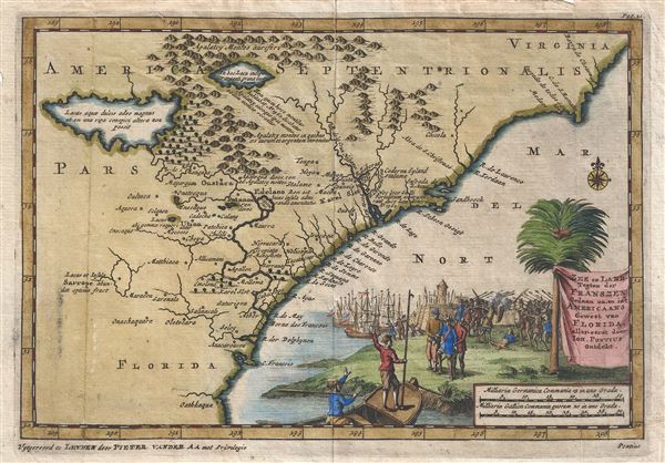
A fine first state first edition example of Pieter Van der Aa's 1706 map of the southeast coast of North America. Covering roughly from Cape Romaine (C. de s. Romano) south to St. Augustine (C. Francois), Van der Aa's map includes parts of modern day Florida, Georgia, Alabama, North Carolina and South Carolina. Van der All drew this map on the Mercator-Hondius model though it does include various updates and more contemporary information. Cartographically the map generally references explorations and discoveries associated with 16th century French attempts under Ribaut and Laudonniere to colonize this coastline. These early French settlements around Port Royal are identified as 'Karel Slot' (Charlefort).
There are three lakes of note in the upper left quadrant, one labeled 'Lacus acuqe dulcis,' a second identified as 'Apalatcy' and a third further south identified as Sarrope. All three of these lakes make their first appearance on the De Bry / Le Moyne map of 1591. The largest of these is represented as the source of the River May. In that chart Le Moyne correctly mapped the River May (St. John's River, Florida) in an inverted 'V' form, first heading north, then south to meet with a large inland lake (in all likely hood Lake George or one of the other great inland lakes of Florida). Hondius on the other hand maps the course of the May heading to the northwest, thus relocating the 'Lacus Aquae Dulcis' far to the north. This error can be understood in terms of magnetic variation, temperature issues associated with isothermal lines, and navigational errors related to the confusion of the star Asfick with Polaris. While Le Moyne correctly located the mouth of the River May at 30 degrees of latitude, Hondius maps it between 31 and 32 degrees. This led to a misassociation of the River May with the Savannah River. Thus, while the real River May dips southward, the Savannah River heads almost directly NW into the Appalachian Mountains, forming the modern southern border of South Carolina. Hondius, no doubt taking his cue from navigators who rarely trekked inland, therefore rerouted the May River to flow from the northwest. Without an accurate picture if the interior, Hondius followed Le Moyne's example and translocated the great freshwater lake to the north. Others have speculated that the Le Moyne's River May is in fact the St. John's River, and that the 'Lacus Aquae Dulcis' is in fact the Okefenokee Swamp - however, this argument runs counter most scholarship. The influence of the Mercator-Hondius firm was so pronounced in Europe that most subsequent cartographers, including as we see her Van der Aa, followed their lead.
Lake Apalatcy, further north, also bears some discussion. Both the De Bry / Le Moyne and the Honduis / Mercator maps of this region depict this map originating from a great waterfalls plunging from between a cleft in the mountains. Some have speculated that this may have derived from early indigenous reports of Niagara Falls, however, this seems doubtful. Be that as it may, Van der Aa is here one of the first to depict this lake without the hallmark waterfall. Most subsequent cartographers abandoned the lake altogether.
The map features a large decorative title cartouche in the lower right quadrant illustrating a pitched battle between American Indian and French Colonists. A large stone fort, far grander than the short lived Charlefort could ever have been, and a bustling harbor appears in the background, while in the foreground a prisoner is loaded onto a boat. Of note is the term 'Pontius' appear in the lower right quadrant just outside the printed border of the map - this refers to Ponce de Leon, the Spanish Conquistador who 'discovered' Florida in the early 16th century.
Van der Aa prepared this map for inclusion in volume 16 of his Naaukerige Versameling, published in 1707. The map itself is generally dated on year earlier in accordance with textual annotation found in the book itself. Several subsequent states followed, including a 1709 edition and a highly decorative 1714 edition. The present example represents the first edition, first state.a
Cartographer
Pieter van der Aa (1659 - 1733) was a Dutch publisher of maps and atlases active in the late 17th and early 18th centuries. Van der Aa was born in Leyden in 1659. At nine he was apprenticed to a local bookseller and, by 21, had established his own publishing, printing, and auctioneering house. In 1692 Van der Aa was appointed to be one of the High Commissioners of the Booksellers Guild. During his long and impressive career Van der Aa produced thousands of maps, including a vast 28 volume atlas containing no less than 3,000 maps. Few of Van der Aa's maps were original productions, most being copied from the work of earlier cartographers. Nonetheless, when one of Van der Aa's rare original pieces does appear, his style, with unusual projections, elegant engraving, and precise detail, is instantly recognizable and highly desirable. He also pioneered the cartographic idea of separating border artwork from the map plate itself such that every map in a collection could have a similar elaborate border without actually having to re-engrave the complex plates. This technique was used to great effect by later 18th century publishers like Brion de la Tour. Following Van der Aa's death in 1733, his much admired Nouvel Atlas was reissued by the Dutch firm of Covens & Mortier. Today Van der Aa's work is admired for its fine delicate engraving and unusual projections and is considered highly desirable among collectors. More by this mapmaker...
Source
Van der Aa, P., Naaukeurige versameling der gedenk-waardigste zee en land-reysen na Oost en West-Indien, (Leyden) 1707.
Condition
Very good. Original fold lines. Blank on verso.
References
Cumming, W., The Southeast in Early Maps, no. 143. Brown University, John Carter Brown Library, F706 A111n. Boston Public Library, Leventhal Collection, G3870 1705.A1. Phillips (Atlases) p. 27.