This item has been sold, but you can get on the Waitlist to be notified if another example becomes available, or purchase a digital scan.
1764 Bellin Map of the Gulf Coast from Mobile Bay to St. Martin's Keys
FloridaGulf-bellin-1764$450.00

Title
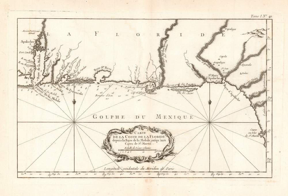
Carte de la Coste de la Floride depuis la Baye de la Mobile jusqu'aux Cayes de St. Martin.
1764 (undated) 8.75 x 13.5 in (22.225 x 34.29 cm) 1 : 1226925
1764 (undated) 8.75 x 13.5 in (22.225 x 34.29 cm) 1 : 1226925
Description
This is a 1764 Jacques-Nicolas Bellin map of the Gulf Coast of Alabama and Florida, from Mobile Bay to St. Martin's Keys.
A Closer Look
The map includes Pensacola Bay, Saint Joseph Bay, the Apalachicola River, Dog Island (Isle des Chiens) and Apalachee Bay. The waters from Mobile Bay to Saint Joseph Bay are marked with depth soundings. Along the shore, several Indigenous settlements are noted, as well as the ruins of the abandoned Fort Louis, the original site of Mobile. Fort de Crevecoeur is shown on Saint Joseph Bay, as well as the fort at St. Marc d'Apalache.Publication History and Census
This map was created by Jaques-Nicolas Bellin and published in his Petit Atlas Maritimein 1764. The atlas is well represented in institutional collections; sixteen separate copies of this map are catalogued in OCLC.Cartographer
Jacques-Nicolas Bellin (1703 - March 21, 1772) was one of the most important cartographers of the 18th century. With a career spanning some 50 years, Bellin is best understood as geographe de cabinet and transitional mapmaker spanning the gap between 18th and early-19th century cartographic styles. His long career as Hydrographer and Ingénieur Hydrographe at the French Dépôt des cartes et plans de la Marine resulted in hundreds of high quality nautical charts of practically everywhere in the world. A true child of the Enlightenment Era, Bellin's work focuses on function and accuracy tending in the process to be less decorative than the earlier 17th and 18th century cartographic work. Unlike many of his contemporaries, Bellin was always careful to cite his references and his scholarly corpus consists of over 1400 articles on geography prepared for Diderot's Encyclopedie. Bellin, despite his extraordinary success, may not have enjoyed his work, which is described as "long, unpleasant, and hard." In addition to numerous maps and charts published during his lifetime, many of Bellin's maps were updated (or not) and published posthumously. He was succeeded as Ingénieur Hydrographe by his student, also a prolific and influential cartographer, Rigobert Bonne. More by this mapmaker...
Source
Bellin, J. N., Le Petit Atlas Maritime Recueil De Cartes et Plans Des Quatre Parties Du Monde. en Cinq Volumes, (Paris) 1764.
Condition
Excellent. Light toning, with generous margins.
References
Touchton Map Library M338. Rumsey 6903.049. OCLC 5409473.