
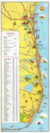
1954 American Automobile Association Pictorial Tourist Map of Florida

This item has been sold.
Florida's Holiday Highways.
Drive Highway 1 in Florida and enjoy the sunshine!
Drive Highway 1 in Florida and enjoy the sunshine!
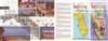
This is a charming c. 1954 American Automobile Association (AAA) pictorial tourist map of Florida. Depicting from Brunswick, Georgia, south along the Atlantic Coast to Miami and continuing to Key West, the map highlights the storied U.S. Highway 1 and several connecting highways along the coast. Pictorial vignettes highlight popular activities, like swimming, deep sea fishing, and golfing. Tourist attractions (many now defunct) like Marineland, the Norton Art Gallery, and Monkey Village are also highlighted. The recently established Everglades National Park extends the map's coverage and is emphasized in verdant green. An index of distances from Jacksonville occupies the left third of the map.Publication History and Census
This map was created and published by the American Automobile Association c. 1954. We have located a single cataloged example, part of the collection at the Touchton Map Library at the Tampa Bay History Center.Cartographer
The American Automobile Association (March 4, 1902 - present), better known as AAA ('Triple-A'), is a federations of motor clubs throughout America. A privately held national member association, AAA boasts over 58 million member in the United States and Canada. Founded on March 4, 1902 in Chicago, Illinois, AAA was originally created in response to a lack of roads and highways that were suitable for cars by nine individual motor clubs, including the Chicago Automobile Club, Automobile Club of America, and Automobile Club of New Jersey. AAA began publishing road maps in 1905 and hotel guides in 1917. Further Details...
Condition
Very good. Exhibits light wear along original fold lines. Text and printed images on verso.
References
Tampa Bay History Center Touchton Map Library 2018.055.039.