This item has been sold, but you can get on the Waitlist to be notified if another example becomes available, or purchase a digital scan.
1893 Pre-Florida East Coast Railway Railroad Map of Florida
FloridaJacksonville-mathewsnorthrup-1894$1,000.00

Title
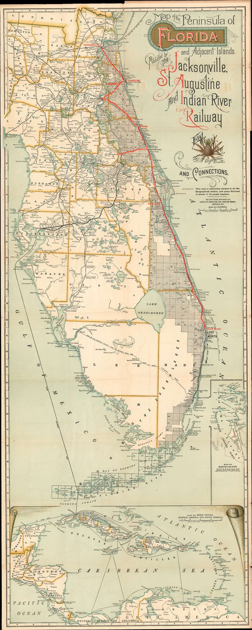
Map of the Peninsula of Florida and Adjacent Islands Published by the Jacksonville, St. Augustine and Indian River Railway.
1894 (undated) 40 x 16 in (101.6 x 40.64 cm) 1 : 887000
1894 (undated) 40 x 16 in (101.6 x 40.64 cm) 1 : 887000
Description
A special rarity for the Florida collector, this is the first-state first-edition of the highly decorative 1894 map of peninsular Florida issued by the Mathews-Northrup Company for the Henry Morrison Flagler’s (1830 - 1913) Jacksonville, St. Augustine, and Indian River Railway, precursor to the Florida East Coast Railway. This is the first state of this famous map, pre-dating all other known examples and contemporaneous with, but in superior condition to, the Library of Congress example. The map covers from the Georgia Border to Key West and Cuba, and from Cedar Key to the Bahamas. The route of the railroad is illustrated in red overprinting extending from Jacksonville to Palm Beach, with major stops at Ormond, and Rockledge. Points further south, as far as Miami, can be reaching via the Lake Worth and Biscayne Bay Stage Line, which began operating around this time. The map also illustrates the 1892 J. E. Ingraham route across the Everglades – an exploratory expedition intended to determine the viability of a cross-Everglades railroad.
The railroad reached New Smyrna in 1892, Cocoa in 1893, Palm Beach in 1894, and Miami in 1896. Flagler constructed sumptuous resorts and founded cities all along the route, among them The Ormond, the Royal Palm, the Royal Poinciana, the Continental, and more. Combined with his railroads, and the Peninsular and Occidental Steamship Company (P. and O. S.S.), Flagler commanded a resort empire spanning the entire east cost of the Florida peninsula.
The Florida East Coast Railway
The Florida East Coast Railway was a major force in the development of Eastern Florida in the late 19th and early 20th century. Spearheaded by the industrialist Henry Flagler, the Florida East Coast Railway fulfilled a vision dating back at least to the 1870s. Before Flagler, Florida south of Jacksonville was serviced by only a few rickety old railroads unconnected to one another. Most access to Florida cities was limited to ferry and steamer services. Flagler bought up most of the failing existing railroads, upgraded them, and connected them with new lines, formally consolidating the network first as the 'Jacksonville, St. Augustine, and Indian River Railway', as here, and then, on September 9, of 1895, as the Florida East Coast Railway.The railroad reached New Smyrna in 1892, Cocoa in 1893, Palm Beach in 1894, and Miami in 1896. Flagler constructed sumptuous resorts and founded cities all along the route, among them The Ormond, the Royal Palm, the Royal Poinciana, the Continental, and more. Combined with his railroads, and the Peninsular and Occidental Steamship Company (P. and O. S.S.), Flagler commanded a resort empire spanning the entire east cost of the Florida peninsula.
The Note
A note from George E. Mathews of the Matthews-Northrup Company (the printer) to Joseph Richardson, St. Augustine Passenger Agent, appears in the inside cover. Dated October 1, 1893, the message conveys the opinion that his map is 'the best map of the peninsula of Florida extant.' It also reveals much of the purpose of the map. It was likely commissioned by Richardson on behalf of the railroad. The intent,So that tourists into whose hands a copy of this map may fall will be enable to easily locate every place in the peninsula and ascertain the routes thereto.Census and Publication History
There are multiple states of this map reflecting the development of the Florida East Coast Railway. This is the earliest known example, published for the 'Jacksonville, St. Augustine, and Indian River Railway', with the railroad terminating at Palm Beach, and note on inside cover dating to 1893. Despite the note, the map most likely dates to 1894, reflecting the railroad reaching Palm Beach. Rumsey’s example of 1896 sees the name changed to Florida East Coast Railroad, and shows tracks extending as far as Miami, with ferry services to Key West. An example at Yale dating to 1906, shows various proposed extensions, in addition to Key West as well as planned ferry services to Cuba and the Bahamas. The Tampa Bay History Center, Touchton Map Library, owns an example showing the track extending as far as Key West dating to 1913. It also has an example, which we presume to be the second edition, wherein the line reaches as far as Lake Worth - shown here as proposed. A final edition, possibly 1915, includes multiple routes to Cuba operated by Flagler’s Peninsular and Occidental Steamship Company (P. and O. S.S.). A more extensive version was published by the Florida Land Department in 1924, showing all railroads and roads in the peninsula. The first edition, as here, is very rare and we are aware of only one other example, at the Library of Congress. Later editions were published in greater numbers and are more common.
Cartographer
Matthews-Northrup Works (fl. c. 1895 - 1930) were a Buffalo, New York based, in their own words, "writing, designing, engraving, printing, [and] binding" firm. The firm was founded by James Newson Matthews (November 21, 1828 - December 20, 1888) as the J. N. Matthews Company. William Phelps Northrup (April 2, 1850 - February 2, 1929) later joined the company as an apprentice and then partner, at which point the firm was reincorporated as the Matthews-Northrup Works. The Matthews-Northrup Works rose to prominence as publishers and printers of railroad maps, with dozens to their credit. When James died, his shares were inhered by George Edward Matthews (1855 - 1910), who ran the business until his death in 1910. Also in 1910, they famously redesigned the cover of National Geographic Magazine. Despite some six previous cover changes in just 21 years, the Matthews-Northrup layout proved so popular that it was used for nearly 50 years. The firm can also take credit for the Winchell typeface, designed in 1903 under E. E. Winchell's tenure as art director. Curiously, the partners of Matthews-Northrup maintained an unusual affectation in which only the officers of the company could wear beards or mustaches. In this same spirit, the firm also had its own private social club, the Fellowcraft Club, where the all-male employees could relax, play pool, drink and dine. Matthews-Northrup maintained offices on Washington Street, Buffalo, where they were based, as well as Madison Square, New York City, Garden Tower, Boston, and the Citizens Building in Cleveland. More by this mapmaker...
Condition
Very good. Wear on original fold lines. Minor edge wear.
References
Library of Congress, G3931.P3 1893 .J3. Rumsey 3893.000. OCLC 70960196. Modelski, A., Railroad Maps of North America: The First Hundred Years, #36.