
1986 Tealls Guide Map of the Florida Keys

This item has been sold.
Teall's Guide to the Florida Keys.
Visit the Florida Keys!
Choose a Collection:
This Item
Enquire
Visit the Florida Keys!
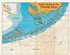
This is a c. 1986 Teall's Guide map of the Florida Keys. Created as a tourist guide to the Keys, individual Keys are labeled from Old Rhodes Key south to Key West. A red dashed line marks the Overseas Highway and red overprinting indicates mile markers every ten miles. Red overprinted 'diver down' flags mark scuba diving sites along the ocean side of the Keys, including at Carysfort Reef, John Pennekamp Coral Reef State Park, and Alligator Reef. Everglades National Park, Biscayne National Park, and the Great White Heron National Wildlife Refuge are identified. An inset map in the upper left corner situates the Florida Keys regionally, with a black box indicating exactly where the area depicted by the map is located.Publication History and Census
This map was created and published by Teall's Guide c. 1986. We note a single cataloged example in OCLC which is part of the collection at the New York Public Library.Condition
Very good. Verso repairs to fold separations. Slight loss at fold intersections. Light soiling. Directory on verso.
References
OCLC 144708365.