This item has been sold, but you can get on the Waitlist to be notified if another example becomes available.
1963 Weld Wilkie Pictorial Map of Napa County, California
NapaCounty2-wilkie-1963$60.00

Title
Beautiful Napa County.
1963 (dated) 17 x 22 in (43.18 x 55.88 cm) 1 : 210000
1963 (dated) 17 x 22 in (43.18 x 55.88 cm) 1 : 210000
Description
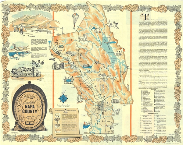
This is a beautiful 1963 pictorial map of Napa County, California, by Weld Wilkie. It covers Napa County, one of the world's premier wine regions, in beautiful detail. It notes several landmarks and places of interest, such as The Old Bale Mill, Breathing Geysers (Geysers Geothermal Field, typo on map as 'Ceysers'), and Robert Louis Stevenson State Park, with a location key in the lower right quadrant. Fifteen principal wineries, including Charles Krug Winery, Beringer Bros. Inc., Inglenook Vineyard Company, and Schramsberg Winery, are also marked with a key in the lower right quadrant. The map is adorned with several illustrations throughout, depicting activities like dining, fishing, horseback riding, trekking, camping, golfing, and water sports, as well as illustrations of animals, trees, and other landmarks. Roads, rivers, lakes, towns, and other topographical features are also noted.
The Illustrations
The bottom left quadrant includes the title cartouche featuring a wine barrel, while the top right quadrant includes information about the history of Napa County. Three large illustrations in the top left quadrant feature the Mt. St. Helena Golf Course at Calistoga, water sports at Lake Berryessa, and the large stone building at St. Helena, reputedly the largest stone winery in the world. Napa County's four scenic seasons, viz. blossom time, summertime, harvest time, and autumn time are explained. A decorative border featuring grapes surrounds the map.Touring Napa
The verso bears information and photographs of four suggested tours: the Lake Berryessa tour, the Wine County tour, A Scenic and Historic Tour of Napa County, and the Landscaped for Living tour. Information and chief attractions of St. Helena and Calistoga are also listed.20th Century Pictorial Maps
This is considered a 'pictorial map' or a 'decorative map' and reflects a style that first began to appear around 1910. As a map its intention is not so much to provide direction as to illustrate the character, famous places, and historical appeal of Napa County. Cartographically speaking, this map style most likely draws its inspiration from late 19th century 'tourist maps' and 'railroad maps'. Tourist Maps, common to major cities in Europe (usually Paris or London), included profiles of notable buildings and monuments and were designed to help foreign tourists identify and navigate to the most important sights. 'Railroad Maps' are a related genre more common to the United States. During the latter part of the 19th century railroad boom, railroad companies began issuing decorative route maps extolling the virtues various regions and their accessibility by rail. Standing somewhere between these two cartographic conventions, our map combines the decorative aspects of both while reducing cartographic value. It may be hard to get from A to B using this map, but its attractive design and decorative flourishes, make it an excellent souvenir and memento of a wonderful Napa County vacation.Publication History and Census
This map was created by Weld Wilkie and copyrighted by Herdell and Beard of St. Helena. It was developed by the Napa County Tourist and Recreation Council and provided by the Napa County Development Council in 1963.CartographerS
Arthur Weld Wilkie (February 7, 1915 - July 6, 2004) was an American artist active in California during the middle part of the 20th century. Wilkie was born in Ashton, Idaho and lived in Idaho until about 1940, after which he is recorded in California. He lived in Mill Valley and San Anselmo, Marin. He produced several pictorial maps, including a map of Napa Valley and Squaw Valley during the 1960 Winter Olympic Games. More by this mapmaker...
Vaughn Mark Herdell (May 6, 1923 - February 3, 1974) was an American printer based in Saint Helena, California. He founded Herdell Printing in 1951, which he ran with his wife Ardis, who he met during World War II. The firm has its roots when Herdell purchased printing equipment form Bob Zulch, setting up a small shop in Saint Helena. They initially paid the bills by printing flyers, advertising, wine labels, small publications including the Redwood Rancher, and college yearbooks. In 1957 he relocated to Vidovich Avenue taking on a partner, Jim Beard, a local letter press printer and typesetter. The imprint changed to 'Herdell and Beard.' The Heardell family bought out Beard's shares of the business in 1965, renaming it Herdell Printing and Lithographers. Herdell died in 1974, at just 49. The firm was taken over by his sons, Michael and Steve Herdell, and daughters. Patty (Herdell) Di Tomaso and Diane (Herdell) Grazian. The firm remains in operation. Learn More...
Condition
Very good. Minor wear along fold lines. Text on verso.