1796 Carey Map of Asia
Asia-carey-1796$200.00

Title
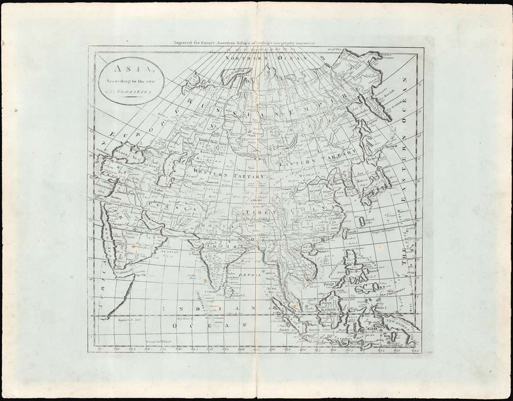
Asia, according to the best authorities.
1796 (undated) 13.25 x 14.5 in (33.655 x 36.83 cm) 1 : 32500000
1796 (undated) 13.25 x 14.5 in (33.655 x 36.83 cm) 1 : 32500000
Description
This is an uncommon c. 1796 map of Asia from Carey's General Atlas, the first atlas published in the United States after Independence. The map stretches from Asia Minor and Arabia across to Japan, the Philippines, and Indonesia, and from the arctic north of Siberia south to the Indian Ocean.
Closer Look
The Gulf of Kutch (here 'G. of Semdi') is too large, as are the Ryukyu Islands (here 'Lekeyo'), but otherwise the map is generally quite accurate, especially along coastlines and even into interior rivers of Siberia, which remained extremely difficult to traverse. The interior geography of Asia, in 'Tartary,' remained poorly understood, but was improving at this time because of exploration and (British and Russian) imperial expansion. Therefore, most cities, many geographic features, and several ethnic groups are indicated here, although the accuracy of terms like 'Uzbek' ('Usbecks') at this time is highly questionable and did not necessarily refer to the people who would today be considered Uzbek by ethnic or national identity.Publication History and Census
This map is likely from an early edition of Carey's General Atlas (sometimes subtitled American Edition of Guthrie's Geography Improved), multiple editions of which were printed between 1795 and 1818. This is likely an early edition as later editions included colored ink to show borders between countries or to shade entire countries. It appears to be identical to the edition included in the David Rumsey Map Collection, which is dated to 1796. The prevalence of the map is difficult to determine since the map is not always cataloged with the year recorded, but aside from the edition in the Rumsey Collection, the map itself is cataloged by the University of Southern California, and the 1796 edition of the entire atlas is held by a handful of universities and research institutions in the United States.Cartographer
Matthew Carey (January 28, 1760 - September 16, 1839) was a Dublin born publisher who established himself in Philadelphia in the late 18th and early 19th century. A young man of socially progressive views, Carey's first known publication, produced when he was but 17 years old, was a pamphlet criticizing dueling. Another pamphlet, issued in the same year, attacked the Irish penal code. Shortly afterwards, in 1779, legal issues, possibly arising from his liberal political activism, forced Carey to flee to Paris. In Paris, Carey had the good fortune to befriend the visiting American diplomat and founding father, Benjamin Franklin (1706 - 1790). As an Irishman chafing under the rule of England, Carey sympathized with and admired the American revolutionary. The liberally minded pair struck up a lifelong friendship and Carey was hired to work at Franklin's press in Passy, France. A year later, Carey returned to Ireland and resumed his politically provocative publishing career with The Freemans's Journal and The Volunteer's Journal. It didn't take long for political pressure to once again force Carey from Ireland - this time to America (1784). Although largely without funds, Carey convinced Gilbert du Motier, Marquis de Lafayette (1757 - 1834), who he knew from Franklin's Paris circle, to lend him funds to establish a new publishing concern in Philadelphia. Despite this loan, Carey's firm remained under financed and opened on a shoestring budget. It was most likely his limited budget that led Carey to some of his most important publishing innovations. At the time cartographic publishing was dominated by large printing houses in London and Paris where most, if not all, of the work was completed in house. Without the finances to emulate this large publishing houses, Carey was forced to outsource much of his publishing work. This set the stage for subsequent American publishers who, in order to compete effectively with European firms, relied on an often bewildering network of alliances and collaborations. Carey was also a master of republishing many of his own maps in multiple different atlases and formats to maximize their profitability. His most important work is without a doubt the 1795 issue of the American Atlas the first atlas to be published in America. Carey died in 1839 but was succeeded by his son Henry Charles Carey (1793 - 1879) who, in partnership with his brother-in-law Isaac Lea (1792 - 1886), published numerous important maps and atlases under the Carey and Lea, Lea Brothers, and Lea and Blanchard imprints. More by this mapmaker...
Source
Carey, M., Carey's General Atlas, (Philadelphia: Carey) 1796.
Condition
Very good. Discoloration and some wear along the fold line. Some foxing.
References
OCLC 984129207. Rumsey 2862.019.