This item has been sold, but you can get on the Waitlist to be notified if another example becomes available.
1969 U.S. Navy Map of Florida and the Southeastern U.S.
FloridaLibertyLimits-navy-1969$225.00

Title
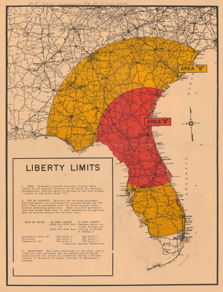
Liberty Limits.
1969 (dated) 20 x 15.5 in (50.8 x 39.37 cm) 1 : 3000000
1969 (dated) 20 x 15.5 in (50.8 x 39.37 cm) 1 : 3000000
Description
This is a c. 1969 U.S. Navy map illustrating the 'liberty limits' for navy-men on leave from the Jacksonville Naval Air Station.
A Closer Look
The map depicts a portion of the southeastern United States, including the entirety of Florida, Georgia, South Carolina, and Alabama, with a red and yellow circle denoting 'Area A' and 'Area B,' respectively. Cities and towns are noted throughout, with highways marked prominently. As the text at bottom-left explains, these areas were the limits within which a serviceman must remain while on leave, with the range granted depending on the duration of leave (48 or 72 hours, the latter occurring on holiday weekends) and the rank of the personnel. Travel beyond these terrestrial and temporal limits required special permission, except in cases of the exemptions explained at bottom. The handwritten note at top refers to the electrician training program of the Naval Air Technical Training Center, part of the larger Naval Air Station at the time.Jacksonville and the Naval Air Station
Jacksonville's modern history is closely tied with the presence of several military facilities, including Naval Air Station Jacksonville (often shortened to NAS Jax). The base, opened in 1940, became a major training center for naval aviators during the Second World War, adding multiple runways (including ones in the St. John's River for seaplanes), hangars, and other structures. Towards the end of the war, the base hosted a large German prisoner-of-war camp. In the late 1940s, NAS Jax led the training that facilitated the adoption of jet planes for the U.S. Navy and became the largest naval airbase on the East Coast of the U.S. Today it remains the largest installation in Navy Region Southeast.Publication History and Census
The map does not contain any publication information, but it presumably was produced at the Naval Air Station itself in 1969 or 1970, based on the note at top. We are not aware of this map being held by any institution.Condition
Good. Some wear on old fold lines and surface scuffing. There is some archival reinforcement on the verso, but no tears.