This item has been sold, but you can get on the Waitlist to be notified if another example becomes available, or purchase a digital scan.
1882 Lorillard / Colton Tobacco Advertising Map of Florida
FloridaLorillard-colton-1882$900.00

Title
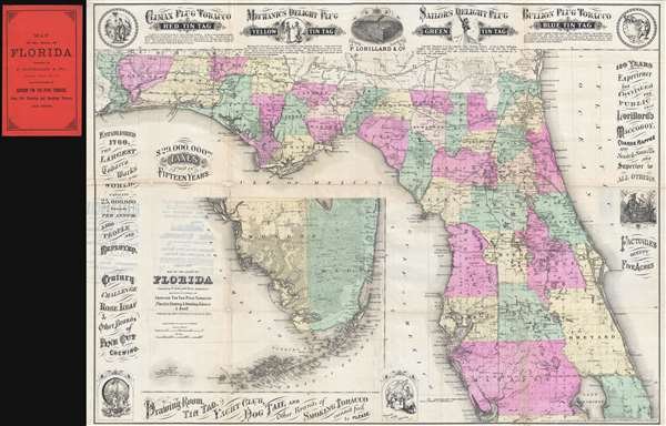
Colton's Map of the State of Florida Presented by P. Lorillard and Co. Jersey City N.J. Manufacturers of Genuine Tin Tag Plug Tobacco Fine Cut Chewing and Smoking Tobacco and Snuff.
1882 (dated) 19.5 x 26.5 in (49.53 x 67.31 cm) 1 : 1140000
1882 (dated) 19.5 x 26.5 in (49.53 x 67.31 cm) 1 : 1140000
Description
This is a rare 1882 promotional advertising map of Florida issued by 'G. W. and C. B. Colton' and Pierre Lorillard. The map was issued to promote the Lorillard Tobacco Company of New Jersey, at the time one of the largest and most profitable tobacco manufacturers in the United States. The map is surrounded by beautifully engraved promotions for Lorillard's 'Tin Tag' tobacco products and for the company in general. Lorillard apparently paid 29,000,000 USD in taxes in 15 years, a truly astronomical sum then, as now.
The map itself is derived from J. H. Colton's map of 1862, although here updated to reflect development up to 1882. It is uncertain why Lorillard, a New Jersey company, chose a map of Florida to promote their products, but Pierre Lorillard IV did have a fondness for the state and maintained an estate in St. Augustine. Some of the famed Lorillard tobacco may also have come from Florida, but we have no found record of Lorillard's suppliers.
As a whole the map is beautifully drawn with great detail through, showing political boundaries, the developing Florida railroad network, swamps, islands, manufactories, and more. That the bulk of the map focuses on northern Florida is no mistake, as, at the time, this was the most developed and populous part of the state. The inset, detailed south Florida and the Keys appears in the lower left. Although Miami is identified, the railroad had not yet been routed so south.
This map is quite rare and we have been able to identify only 3 other examples, two in university archives and one at the Library of Congress.
Cartographer
Joseph Hutchins Colton (July 5, 1800 - July 29, 1893), often publishing as J. H. Colton, was an important American map and atlas publisher active from 1833 to 1897. Colton's firm arose from humble beginnings when he moved to New York in 1831 and befriended the established engraver, Samuel Stiles. He worked under Stiles as the 'Co.' in Stiles and Co. from 1833 to 1836. Colton quickly recognized an emerging market in railroad maps and immigrant guides. Not a cartographer or engraver himself, Colton's initial business practice mostly involved purchasing the copyrights of other cartographers, most notably David H. Burr, and reissuing them with updated engraving and border work. His first maps, produced in 1833, were based on earlier Burr maps and depicted New York State and New York City. Between 1833 and 1855, Colton proceeded to publish a large corpus of guidebooks and railroad maps, which proved popular. In the early 1850s, Colton brought his two sons, George Woolworth Colton (1827 - 1901) and Charles B. Colton (1832 - 1916), into the map business. G. W. Colton, trained as a cartographer and engraver, was particularly inspired by the idea of creating a large and detailed world atlas to compete with established European firms for the U.S. market. In 1855, G.W. Colton issued volume one of the impressive two-volume Colton's Atlas of the World. Volume two followed a year later. Possibly because of the expense of purchasing a two-volume atlas set, the sales of the Atlas of the World did not meet Colton's expectations, and so, in 1856, the firm also issued the atlas as a single volume. The maps contained in this superb work were all original engravings, and most bear an 1855 copyright. All of the maps were surrounded by an attractive spiral motif border that would become a hallmark of Colton's atlas maps well into the 1880s. In 1857, the slightly smaller Colton's General Atlas replaced the Atlas of the World. Most early editions of the General Atlas published from 1857 to 1859 do not have the trademark Colton spiral border, which was removed to allow the maps to fit into a smaller format volume. Their customers must have missed the border because it was reinstated in 1860 and remained in all subsequent publications of the atlas. There were also darker times ahead; in 1858, Colton was commissioned at a sum of 25,000 USD by the government of Bolivia to produce and deliver 10,000 copies of a large format map of that country. Although Colton completed the contract in good faith, delivering the maps at his own expense, he was never paid by Bolivia, which was at the time in the midst of a series of national revolutions. Colton would spend the remainder of his days fighting with the Bolivian and Peruvian governments over this payment, and in the end, after a congressional intervention, he received as much as 100,000 USD in compensation. Nonetheless, at the time, it was a disastrous blow. J. H. Colton and Company is listed as one of New York's failed companies in the postal record of 1859. This led Colton into the arms of Alvin Jewett Johnson and Ross C. Browning. The 1859 edition of Colton's General Atlas lists Johnson and Browning as the 'Successor's to J. H. Colton' suggesting an outright buyout, but given that both companies continued to publish separately, the reality is likely more complex. Whatever the case may have been, this arrangement gave Johnson and Browning access to many of Colton's map plates and gave birth to Johnson's New Illustrated (Steel Plate) Family Atlas. The Johnson's Atlas was published parallel to Colton's atlases well into the 1880s. The Colton firm itself subsequently published several other atlases including an Atlas of America, the Illustrated Cabinet Atlas, the Octavo Atlas of the Union, and Colton's Quarto Atlas of the World. They also published a large corpus of wall maps, pocket maps, and guides. The last known publications of the Colton firm date to 1897 and include a map and a view, both issued in association with the Merchant's Association of New York. Alice M. Colton married August R. Ohman (May 3, 1859 - April 22, 1934) on January 5, 1897. In 1898, Ohman joined the Colton firm, which continued to publish as Colton, Ohman & Co. until 1901. More by this mapmaker...
Condition
Good. Backed on archival tissue. A few minor areas of loss, mostly at fold intersections, repaired. Accompanied by original red paper binder.
References
OCLC 647804278. Phillips (America) page 286.