This item has been sold, but you can get on the Waitlist to be notified if another example becomes available, or purchase a digital scan.
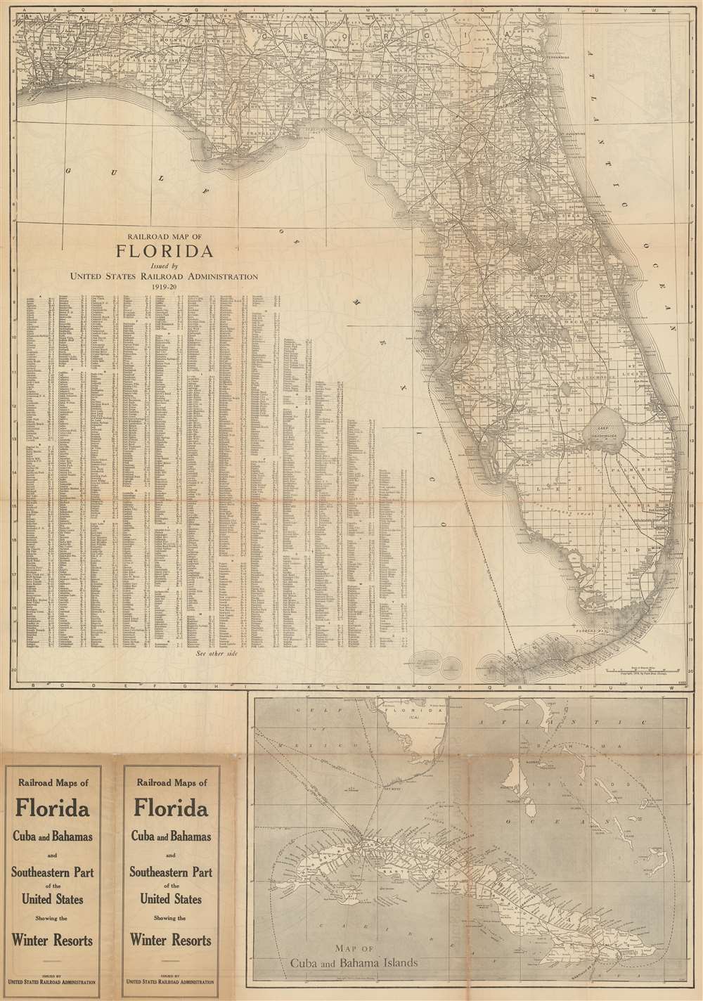
1915 Poole Brothers Railroad Map of Florida
FloridaRailroads-poolebros-1915$62.50

Title
Railroad Map of Florida Issued by United States Railroad Administration 1919-20.
1915 (dated) 36 x 25 in (91.44 x 63.5 cm) 1 : 1267200
1915 (dated) 36 x 25 in (91.44 x 63.5 cm) 1 : 1267200
Description
This is a 1915 Poole Brothers railroad map of Florida published by the United States Railroad Administration in 1919. The map depicts the state from Pensacola to the Atlantic Ocean and from Alabama and Georgia to Key West. Solid black lines illustrating railroad routes wind their way across Florida in every direction, connecting major cities, such as Jacksonville, Tallahassee, Tampa, Orlando, and Miami, while stopping at innumerable smaller cities and towns along the way. Every stop on every line is labeled. Counties throughout Florida are illustrated and labeled as well, as are Florida's numerous rivers and lakes. The entire state is also overlaid with the grid of the public land survey system and, allowing the viewer to precisely locate a single township anywhere in Florida. An alphabetic index of cities and towns is situated in the Gulf of Mexico and provides the grid location on the map for each locality. Below the map's bottom border a railroad map of Cuba is included that also illustrates shipping lanes between numerous Caribbean and American ports.
Publication History and Census
This map was created by Poole Brothers in 1915 and published by the United States Railroad Administration in 1919. The OCLC records four examples in institutional collections which are part of the collections at the Wisconsin Historical Society, the University of Missouri - St. Louis, Florida State University, and the William Clements Library at the University of Michigan.Cartographer
Poole Brothers (1878 - 1968) were a Chicago based firm active in the late 19th and early 20th century with an initial focus on promotional railroad maps. Poole Brothers was founded by George Amos Poole (March 20, 1843 – September 7, 1918). In 1868, Poole, along with his uncle William H. Rand (1828 - 1915) and Andrew McNally (1836 - 1904), purchased the Chicago Tribune's job printing plant and formed the firm Rand McNally. In 1878, he left Rand McNally to form, with his brother William H. Poole, Poole Brothers, a direct competitor to Rand McNally for the lucrative railroad business. Like many of its competitors, Poole Brothers maintained an office on Chicago's Printer's Row (downtown Loop district). Their earliest known work is an 1880 map of Yellowstone National Park. In 1887, Poole Brothers, Andrew McNally, and several others formed the United Typothetae of America, a master printers association. In 1848, they were cited, along with Rand McNally and George Cram, by the Federal Trade Commission for price fixing. Their earliest known work is an 1880 map of Yellowstone National Park. Afterward they went on to produce a vast range of maps and other print products including tickets, cards, coupons, and restaurant menus. In time Poole Brothers merged with Newman-Randolph, which was then acquired by the American Can Company in the early 1960s. The American Can Company liquidated its printing concerns later in the same decade. More by this mapmaker...
Condition
Good. Even overall toning. Verso repairs to fold separations. Slight loss at some fold intersections. Railroad Map of Southeastern United States on verso.
References
OCLC 35228081 ; 82695410.