This item has been sold, but you can get on the Waitlist to be notified if another example becomes available, or purchase a digital scan.
1881 Colton Map of Florida
FloridaSectional-colton-1882$1,120.00

Title
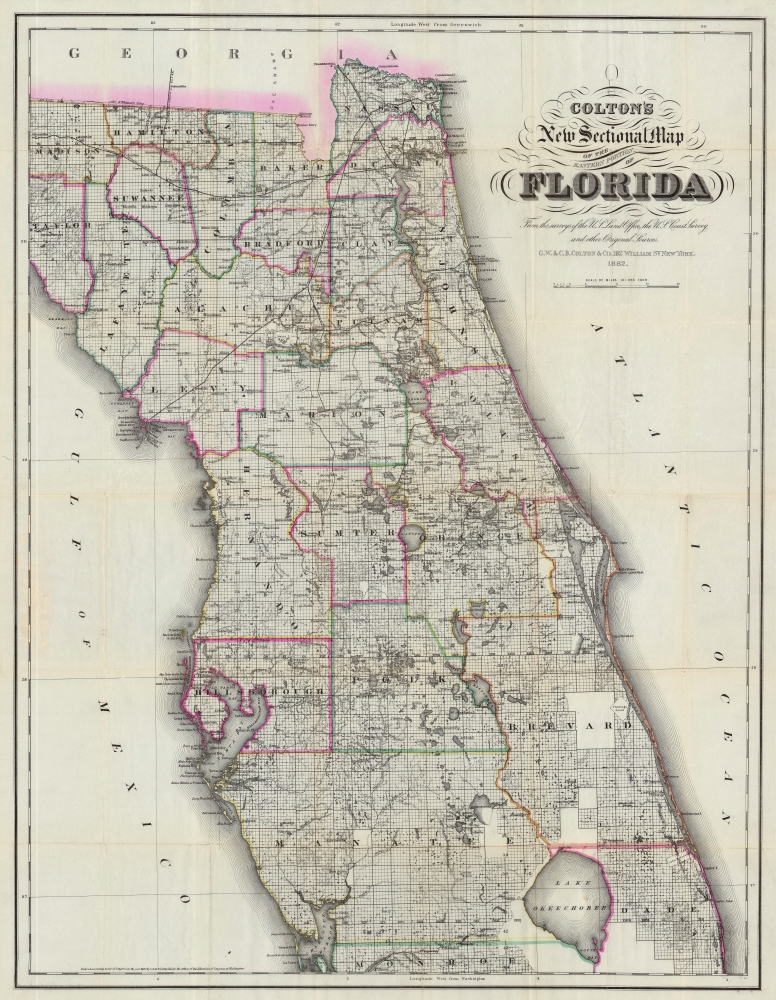
Colton's New Sectional Map of the Eastern Portion of Florida.
1882 (dated) 31 x 24 in (78.74 x 60.96 cm) 1 : 633600
1882 (dated) 31 x 24 in (78.74 x 60.96 cm) 1 : 633600
Description
This is a striking large-scale 1882 map of northern and central Florida by G. W. and C. B. Colton - illustrating the most populous part of the state at the outset of the late 19th century Florida Land Boom. The map is derived from Florida Land Office, U.S. Coast Survey, and railroad survey work compiled up to 1882 - making it one of the largest and most detailed maps of central Florida of its generation. The map is further unique for its illustration of vast land grants. Some of these date to the Spanish era, but others, such as Levy's Jewish settlements, are more recent. Most of which were locked in litigation throughout the second half of the 19th century.
In the wake of the Napoleonic Wars (1800 - 1815) European Jews were suffering extreme persecution in Europe, but in the United States they could enjoy rights as full citizens. He imagined his settlement, called the Pilgrimage Plantation, as a utopian haven where European Jews could escape anti-Semitism in a Moshav-like social and political setting. Unfortunately, lacking the vast capital required to develop the sprawling grants, the settlement never really took off. By 1828, only 21 Jews settled on Levy’s land. Pilgrimage Plantation was devastated during the Second Seminole War (1835 - 1842), after which it never recovered, and the notion an exclusively Jewish settlement in Florida was abandoned. Moreover, Levy's properties presupposed United States recognition of Spanish land grants, which the Federal government opposed. Levy was financially devastated by lengthy court battles that ultimately validated nearly 100,000 acres of his Florida grant holdings - but in the end, this was only a small portion of the total land he had amassed. He died in September 1854 and his remaining land holdings passed to heirs before being broken up and sold.
Florida Railroads
This map's focus on central Florida underscores the rapid economic, infrastructure, and real-estate development that was then going on. Multiple railroad concessions were granted, including the 'South Florida Railroad' and the 'Atlantic, Gulf and West India Transit Company'. On this map, each of these routes has established tracking connecting the major central Florida lakes, for example connecting Lake Eustis with Lake George, and hence to the navigable St. John's River. Developed lateral routes across the state also connected Jacksonville with Pensacola and Mobile. As of 1881, when this map was first issued, no railroads extended south of Orlando. By the second edition, 1884, the South Florida Railroad reached Tampa.Second Florida Land Boom
In the second half of the 19th and throughout the early 20th century, Florida experienced a series of land booms and crashes. The first followed the Second Seminole War (1835 - 1842), when the government offered homesteaders who agreed to stay five years 160 acres of free land. The second - represented on this map - follows the arrival of the railroads to central Florida, leading to nearly 15 years of prosperity and economic growth - mostly revolving around the booming citrus industry. New settlements sprang up throughout the northern half of the state, many owned by absentee investors who never personally visited Florida. The boom collapsed in 1894-95 when a series of historical freezes wiped out the citrus harvest. Property depreciation following the freezes allowed Henry Flagler (1830 - 1913) to develop the Florida East Coast Railway. This, and the arrival of the highway system in the 1920s, led to the third Florida land boom from 1920 to the stock market crash of 1929.Levy's Jewish Colony in Florida
One of the more interesting grants presented here are the massive tracts throughout central Florida assigned to Moses Elias Levy (1782 - 1854). Levy was a Moroccan-born Sephardic Jew, Proto-Zionist, Abolitionist, and pioneer who emigrated to the United States from Mogador, Morocco. He built a fortune in the slave trade before experiencing an epiphany and turning his life towards philanthropic goals, including the establishment of a Jewish settlement in Florida and the gradual abolition of slavery. Levy himself did not receive a Florida grant, instead, in 1819 he purchased the land from his friend, the Spanish-Cuban grantee Alejandro Ramierz. The initial purchase consisted of some 53,000 acres in central Florida on which Levy planned to establish a proto-Zionist 'New Jerusalem.' Later, Levy bought up additional grants throughout central Florida.In the wake of the Napoleonic Wars (1800 - 1815) European Jews were suffering extreme persecution in Europe, but in the United States they could enjoy rights as full citizens. He imagined his settlement, called the Pilgrimage Plantation, as a utopian haven where European Jews could escape anti-Semitism in a Moshav-like social and political setting. Unfortunately, lacking the vast capital required to develop the sprawling grants, the settlement never really took off. By 1828, only 21 Jews settled on Levy’s land. Pilgrimage Plantation was devastated during the Second Seminole War (1835 - 1842), after which it never recovered, and the notion an exclusively Jewish settlement in Florida was abandoned. Moreover, Levy's properties presupposed United States recognition of Spanish land grants, which the Federal government opposed. Levy was financially devastated by lengthy court battles that ultimately validated nearly 100,000 acres of his Florida grant holdings - but in the end, this was only a small portion of the total land he had amassed. He died in September 1854 and his remaining land holdings passed to heirs before being broken up and sold.
Other Grants
The map notes a host of additional grants, most of which were holdovers from Spanish Florida. These include the Arredondo Grant, Atkinson's Grand, the Fernandez Grant, the Sanchez Grant, the Miranda Grants, Charles Sibbald's grant, and many others. Arredondo's Grant and Miranda's Grant, among the largest, are interesting case studies. Beginning in the 1790s, the Spanish crown offered land grants to people courageous enough to emigrate to Florida or for meritorious service to the crown. The Spanish merchant Fernando de la Maza Arredondo controlled multiple grants, but the largest was located to the west of St. Augustine in Alachua County. It was granted to Arredondo in 1817 by Alejandro Ramirez of Havana. Miranda's Grants, after Pedro Miranda, a Spanish sailor, appear here and there throughout the map. After Florida became a possession of the United States in 1821, these grants developed into a point of contention. Initially, the U.S. government declared it would honor the grants as long as the owner could prove their legitimacy. Both Pedro Miranda and Fernando de la Maza Arredondo took their cases to the United States Supreme Court, where their rights to the land were initially affirmed. Eventually, nonetheless, both grants were dissolved by U.S. courts on the basis that they were not properly developed and therefore forfeited.Publication History and Census
This map was issued in 1882 by G. W. and C. B. Colton. It is a lithographic production based upon cartographic work completed by various government land offices, both state and federal, the U.S. Coast Survey, and private railroad surveys. A first edition preceded the present edition in 1881, with subsequent editions in 1883, 1884, and 1886. The 1886 edition had an additional map of the Florida panhandle and south Florida appended. The map is well represented institutionally but scarce on the market.Cartographer
Joseph Hutchins Colton (July 5, 1800 - July 29, 1893), often publishing as J. H. Colton, was an important American map and atlas publisher active from 1833 to 1897. Colton's firm arose from humble beginnings when he moved to New York in 1831 and befriended the established engraver, Samuel Stiles. He worked under Stiles as the 'Co.' in Stiles and Co. from 1833 to 1836. Colton quickly recognized an emerging market in railroad maps and immigrant guides. Not a cartographer or engraver himself, Colton's initial business practice mostly involved purchasing the copyrights of other cartographers, most notably David H. Burr, and reissuing them with updated engraving and border work. His first maps, produced in 1833, were based on earlier Burr maps and depicted New York State and New York City. Between 1833 and 1855, Colton proceeded to publish a large corpus of guidebooks and railroad maps, which proved popular. In the early 1850s, Colton brought his two sons, George Woolworth Colton (1827 - 1901) and Charles B. Colton (1832 - 1916), into the map business. G. W. Colton, trained as a cartographer and engraver, was particularly inspired by the idea of creating a large and detailed world atlas to compete with established European firms for the U.S. market. In 1855, G.W. Colton issued volume one of the impressive two-volume Colton's Atlas of the World. Volume two followed a year later. Possibly because of the expense of purchasing a two-volume atlas set, the sales of the Atlas of the World did not meet Colton's expectations, and so, in 1856, the firm also issued the atlas as a single volume. The maps contained in this superb work were all original engravings, and most bear an 1855 copyright. All of the maps were surrounded by an attractive spiral motif border that would become a hallmark of Colton's atlas maps well into the 1880s. In 1857, the slightly smaller Colton's General Atlas replaced the Atlas of the World. Most early editions of the General Atlas published from 1857 to 1859 do not have the trademark Colton spiral border, which was removed to allow the maps to fit into a smaller format volume. Their customers must have missed the border because it was reinstated in 1860 and remained in all subsequent publications of the atlas. There were also darker times ahead; in 1858, Colton was commissioned at a sum of 25,000 USD by the government of Bolivia to produce and deliver 10,000 copies of a large format map of that country. Although Colton completed the contract in good faith, delivering the maps at his own expense, he was never paid by Bolivia, which was at the time in the midst of a series of national revolutions. Colton would spend the remainder of his days fighting with the Bolivian and Peruvian governments over this payment, and in the end, after a congressional intervention, he received as much as 100,000 USD in compensation. Nonetheless, at the time, it was a disastrous blow. J. H. Colton and Company is listed as one of New York's failed companies in the postal record of 1859. This led Colton into the arms of Alvin Jewett Johnson and Ross C. Browning. The 1859 edition of Colton's General Atlas lists Johnson and Browning as the 'Successor's to J. H. Colton' suggesting an outright buyout, but given that both companies continued to publish separately, the reality is likely more complex. Whatever the case may have been, this arrangement gave Johnson and Browning access to many of Colton's map plates and gave birth to Johnson's New Illustrated (Steel Plate) Family Atlas. The Johnson's Atlas was published parallel to Colton's atlases well into the 1880s. The Colton firm itself subsequently published several other atlases including an Atlas of America, the Illustrated Cabinet Atlas, the Octavo Atlas of the Union, and Colton's Quarto Atlas of the World. They also published a large corpus of wall maps, pocket maps, and guides. The last known publications of the Colton firm date to 1897 and include a map and a view, both issued in association with the Merchant's Association of New York. Alice M. Colton married August R. Ohman (May 3, 1859 - April 22, 1934) on January 5, 1897. In 1898, Ohman joined the Colton firm, which continued to publish as Colton, Ohman & Co. until 1901. More by this mapmaker...
Condition
Very good. A few verso repairs and reinforcements to fold separations. Accompanied by original binder.
References
Tampa Bay History Center, Touchton Map Library, #L2019.092.012, #L2019.092.013, #L2018.087.056, #L2019.092.008.