
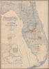
1888 Elliott / Matthews Northrup Folding Map of the Plant System, Florida

This item has been sold.
A New Sectional Map of Florida.
First map of the 'Plant System' in Florida.
- Digital Map Information
- Suitable for large format printing
- Full resolution TIFF file
- ICC color profile embedded
- Delivered instantly via download link
First map of the 'Plant System' in Florida.
This is a rare 1888 large-format map of Florida prepared by the Land Department of the South Florida Railroad and the Plant Investment Company, and printed by Matthews, Northrup, and Co. It depicts 'Plant System' of railroad and land magnate Henry B. Plant (1819 - 1899) as it was reaching its apex, expanding into South Florida and linking it with wider regional rail and steamship connections.A Closer Look
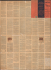
The map displays the state of Florida with county boundaries, survey (township and range) lines, waterways, railways, and steamship routes indicated. The survey lines divide the state into large squares of 36 square miles, composed of 36 smaller squares of 1 square mile each. The one-square-mile plots belonging to the South Florida Railroad and Plant Investment Companies are shaded red, demonstrating that the Plant System owned hundreds of square miles of land in Florida; in subsequent years, it would add many more, especially in South Florida. An inset map at left presents the Plant System amid the wider context of the southeastern U.S. and the Caribbean. The verso contains extensive promotional text advertising the state's climate and soil and their ability to support a wide range of crops, indicating that intended buyers were primarily farmers rather than retirees and vacationers.Historical Context
The Plant System Investment Company was formed in 1882. The 'Plant System' grew out of the Savannah, Florida and Western Railway, which initially ran across southern Georgia. It grew coverage by leasing or buying other railroads, among them the Charleston Railroad and the Brunswick and Western Railroad. It also began acquiring steamship lines, extending coverage from Tampa to Cuba, Key West, and other points. In its later years, the Plant system was in competition with Henry Flagler's Florida East Coast Railroad. It was taken over by the Atlantic Coast Line Railroad in 1902.Florida's breakneck development in the late 19th century was driven by the land departments of private transportation syndicates, especially the Plant Investment Company. Following the American Civil War (1861 - 1865), the state's Internal Improvement Fund was heavily in debt, leading to a sell-off of public lands to wealthy developers who promised to build infrastructure. Henry B. Plant leveraged these conditions to acquire millions of acres of land as subsidies for every mile of track his company laid. These land development departments acted as the primary architects of the region, meticulously surveying the wilderness to establish new townships, agricultural colonies, and commercial hubs that turned Florida's wetlands into high-value real estate for Northern settlers.
The success of these development efforts was entirely dependent on their integration with the Plant System. The land department's strategy was a classic example of vertical integration: the railroads provided physical access to the interior, while the steamship lines opened international trade routes for the citrus and phosphate produced on the developed land. By coordinating these transportation schedules, the Plant System ensured that any land it sold was backed by a reliable logistics chain.
Provenance
The map is addressed (on the verso binder boards when folded) to 'Mrs. Henry Snyder' at Miami University in Oxford, Ohio, who was the wife of a prominent chemistry professor at the university. Mrs. Snyder, named Minnie, was a colorful figure 'who delighted in exotic, gypsy dress and fancied herself a great singer.' She would accompany her husband's chemistry lectures with musical numbers to spice them up. However, in 1898, the health of the still-fairly-young (42) and previously healthy Prof. Snyder declined rapidly, and he died that year by apparent suicide, ingesting potassium cyanide, though some have speculated that he was killed by his laboratory assistant, who later married his widow, Minnie.Publication History and Census
This map was prepared in 1888 by D. H. Elliott of the Land Department of the South Florida Railroad and the Plant Investment Company and printed by Matthews, Northrup, and Co. The inset map was prepared by John W. Newman, a surveyor with the South Florida Railroad. This is the earliest edition of this map, which was reissued by Matthews-Northrup periodically until 1923, initially for the Plant System-affiliated Associated Railway Land Department of Florida (of which Elliott became the Land Manager) and later for the State of Florida (see, for example, our earlier listing Florida-matthewsnorthrup-1917). Examples are cataloged at the Tampa Bay History Center's Touchton Map Library, the State Library of Florida, the Library of Congress, and the Pennsylvania State University. Rare to the market.Cartographers
David H. Elliott (c. 1840 - September 30, 1900), a.k.a. 'Colonel', was a leading figure in the agricultural community, a journalist, a railway agent, and an all-around 'booster' active in Florida and the southeastern U.S. in the late 19th century. Details of his biography are scant but he appears to have been born in Alabama and likely served in the U.S. Civil War on the side of the Confederacy, resulting in his commonly used title, Colonel. Elliott founded the agricultural periodical The Florida Dispatch in the 1870s, and afterwards became associated with the Plant System of railroads, often touring with potential land buyers around the state and traveling to other states to promote Florida as a destination for investment and settlers. Perhaps most impressively, he commissioned a colossal map of Florida's phosphate lands for the 1895 Cotton States and International Exposition in Atlanta Georgia. The map consisted of ten sheets, each 4.5 x 10 feet in size, resulting in a map covering 900 square feet of wall space when joined. He served as the General Land Agent of the Plant-affiliated Associated Railway Land Department of Florida for much of the 1890s. He also was for many years the secretary and treasurer of the Florida Press Association, and also served as secretary of the Florida Fruit-Growers Association and Chairman of the Committee of Transportation of the Florida Horticultural Society. After working for the Plant System, Elliott managed the Florida Dispatch Line, a freight railway that primarily handled produce bound for northern markets. At the time of his death, Elliott was working as Land Agent for the Southern Railway in Charleston, South Carolina. Further Details...
Matthews-Northrup Works (fl. c. 1895 - 1930) were a Buffalo, New York based, in their own words, "writing, designing, engraving, printing, [and] binding" firm. The firm was founded by James Newson Matthews (November 21, 1828 - December 20, 1888) as the J. N. Matthews Company. William Phelps Northrup (April 2, 1850 - February 2, 1929) later joined the company as an apprentice and then partner, at which point the firm was reincorporated as the Matthews-Northrup Works. The Matthews-Northrup Works rose to prominence as publishers and printers of railroad maps, with dozens to their credit. When James died, his shares were inhered by George Edward Matthews (1855 - 1910), who ran the business until his death in 1910. Also in 1910, they famously redesigned the cover of National Geographic Magazine. Despite some six previous cover changes in just 21 years, the Matthews-Northrup layout proved so popular that it was used for nearly 50 years. The firm can also take credit for the Winchell typeface, designed in 1903 under E. E. Winchell's tenure as art director. Curiously, the partners of Matthews-Northrup maintained an unusual affectation in which only the officers of the company could wear beards or mustaches. In this same spirit, the firm also had its own private social club, the Fellowcraft Club, where the all-male employees could relax, play pool, drink and dine. Matthews-Northrup maintained offices on Washington Street, Buffalo, where they were based, as well as Madison Square, New York City, Garden Tower, Boston, and the Citizens Building in Cleveland. Further Details...
John William Newman (May 23, 1845 - 1914) was a surveyor and civil engineer active in Florida in the late 19th century. Sources differ on his birth date and year, but he was born 'on a plantation' in Orange County, Virginia. He joined the Confederate army at the start of the U.S. Civil War while only 25 and, showing a proficiency for mathematics, was assigned to the engineering corps, reaching the rank of captain by the end of the conflict. After the war he moved to Kentucky and ran a military school called Forrest Academy. He married Mary Barbour in 1867 and had four children with her, but after she died in 1884, he relocated to Florida and remarried (Louise or Lula Kabler), having four additional children. In the early 1890s, Newman was employed by Henry Plant, of the Plant System of railroads and steamships, as a civil engineer. He was tasked by Plant in 1892 with conducting a survey of the Everglades, which were still poorly mapped at the time, as part of the 'Ingraham Everglades Expedition,' named for the president of Plant's South Florida Railroad, James E. Ingraham. The expedition traveled from Fort Myers to Miami with the stated goal of surveying the land and planning out a railway route, though its implicit goal was also to determine whether the Everglades could be drained and put to agricultural use, as Plant and his associates had done further north in Florida. Newman produced an important map of the Everglades upon the expedition's completion and then dedicated himself to the monumental task of draining the Everglades, which he was convinced was possible (Ingraham, in the meantime, returned to northern Florida and convinced Henry Flagler to expand his expanding railway network - soon redubbed the Florida East Coast Railway - all the way down the coast of the state). In 1896, Newman moved to Bellair (west of Tampa near Clearwater) and with his family and oversaw drainage operations in South Florida, serving as the Engineer for the Trustees of the Internal Improvement Fund. From 1905 to 1911, he managed canal and dredging operations on both the east and west coasts of South Florida, including Fort Lauderdale and Caloosahatchee (near Fort Myers). Further Details...
Condition
Very good. Some discolorations and minor points of verso stabilization. Attached to original boards.
References
Tampa Bay History Center, Touchton Map Library Accession Number: L2018.078.023. OCLC 921226182, 39528069.