This item has been sold, but you can get on the Waitlist to be notified if another example becomes available, or purchase a digital scan.
1913 British Admiralty Chart of Florida, the Bahamas, Cuba and Hispaniola
FloridaWestIndies-admiralty-1913$325.00

Title
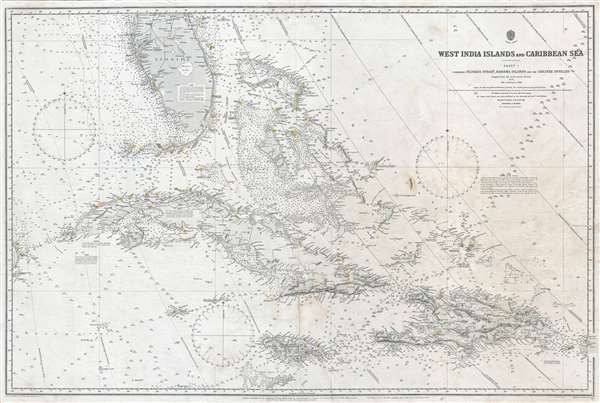
West India Islands and Caribbean Sea. Sheet 1. Comprising Florida Strait, Bahama Islands and the Greater Antilles.
1913 (dated) 26 x 39 in (66.04 x 99.06 cm) 1: 2062000
1913 (dated) 26 x 39 in (66.04 x 99.06 cm) 1: 2062000
Description
A very attractive 1913 British Admiralty Hydrographic Office nautical chart or maritime map of the West Indies, specifically the Greater Antilles (Cuba, Hispaniola), the Bahamas, Jamaica, and peninsular Florida. This is sheet 1 of the British West Indies and Caribbean Sea series. The chart features extensive depth soundings, in fathoms throughout and well as yellow and red indications of buoys, lighthouse, and light boats. Consistent with Admiralty stylistics, there is little inland detail beyond basic topography and notations of some inland river and lake systems. This particular chart exhibits some manuscript annotations in pencil highlighting additional shoals and offering occasional additional depth soundings.
The Admiralty first published this chart in 1876 under the superintendence of Captain F. J. Evans, Hydrographer. New Editions followed in 1887, 1904, 1907, 1908, and as here, March 5, 1913. It was engraved by Davies and Company. Admiralty Chart no. 761.
The Admiralty first published this chart in 1876 under the superintendence of Captain F. J. Evans, Hydrographer. New Editions followed in 1887, 1904, 1907, 1908, and as here, March 5, 1913. It was engraved by Davies and Company. Admiralty Chart no. 761.
Cartographer
The British Admiralty Office (1795 - Present) or the United Kingdom Hydrographic Office refers to the Branch of the English government that is responsible for the command of the British Navy. In 1795 King George III created the United Kingdom Hydrographic Office, known in short as the U.K.H.O., to provide top notch nautical charts to the vast Royal Navy. Prior the founding of the Admiralty the surveying and creation of nautical charts was primarily a commercial venture wherein the cartographer himself, more of than not, actually financed the printing of his own material. The great navigator Cook himself is known to have scrambled for funds to publish his own seminal charts - the most important and advanced of the period. The system of privately funded nautical mapping and publishing left vast portions of the world uncharted and many excellent charts unpublished. King George III, responding significant loss in trade revenue related to shipwrecks and delay due to poor charts, recognized the need for an institutionalized government sponsored cartographic agency - the Admiralty. The first head of the Admiralty, a position known as Hydrographer, was the important cartographer Alexander Dalrymple. Dalrymple started by organizing and cataloging obtainable charts before initiating the laborious process of updating them and filling in the blanks. The first official Admiralty Chart appeared in 1800 and detailed Quiberon Bay in Brittany. By 1808 the position of Hydrographer fell to Captain Thomas Hurd. Hurd advocated the sale of Admiralty charts to the general public and, by the time he retired in 1829, had issued and published some 736 charts. Stewardship of the organization then passed to Rear Admiral Sir Francis Beaufort. It was under Beaufort's administration that the Admiralty truly developed as a "chart making" as opposed to a "chart cataloging" institution. Beaufort held his post from 1829 to 1854. In his 25 years at the Admiralty Beaufort created nearly 1500 new charts and sponsored countless surveying and scientific expeditions - including the 1831 to 1836 voyage of the H.M.S. Beagle. By 1855 the Admiralty's chart catalog listed some 1,981 charts. More by this mapmaker...
Condition
Good. Minor soiling and creasing. A couple of minor verso repairs to closed tears at margins.