This item has been sold, but you can get on the Waitlist to be notified if another example becomes available, or purchase a digital scan.
1883 Scribner's Map of the United States Illustrating Immigrant Population
ForeignPopulation-scribners-1883$125.00

Title
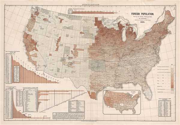
Foreign Population. Ration to Total Population, by Counties. (Based on the Returns of the Tenth Census.)
1883 (dated) 17 x 24.75 in (43.18 x 62.865 cm) 1 : 5230000
1883 (dated) 17 x 24.75 in (43.18 x 62.865 cm) 1 : 5230000
Description
This is an 1883 Fletcher W. Hewes and Charles Scribner's Sons political / immigration map of the United States. The map depicts the continental United States from the Pacific Ocean to the Atlantic Ocean and from Canada to Mexico. As immigration had become a pressing domestic issue during the late 19th century, here Hewes and Scribner's illustrate the percentage of each county that can be identified as 'foreign' with relation to the total population of said county, as of 1880. Since the returns from the 1880 census acted as source material for these percentages, it is likely that the numbers reflect self-identified 'foreigners', although the exact definition of 'foreigner' is unclear. The definition appears to be anyone that is not a 'native white'.
Meticulously detailed, each county is illustrated, numbered, and shaded in a manner that corresponds with the key along the right border. The key informs the viewer that the different shades of brown utilized indicate varying percentages of each county's population that were identified as 'foreign', increasing from no foreign population reported to 40% and over of the county's population. Unsettled regions of the country are also indicated in a unique way, allowing for the viewer to easily recognize which parts of the country are uninhabited. Native American reservations are also illustrated and labeled with the name of the tribe and the number of people living in each reservation.
Numerous graphs and tables populate the area surrounding the central map, along with an inset map of the United States along the bottom border. The inset map illustrates the percentage of each state's population that identified as 'foreign', with the shading matching the scheme used on the central map. To the right of the inset map, a table bears data concerning the number of foreign-born people in a given state per 1,000 native whites. Three different graphs are situated in the lower left corner. The top graph illustrates the percent of foreign-born people to the total population of each state by state, from lowest to highest concentration. The graph in the corner gives the total number of foreign-born people in each state from least to greatest, while the graph next to it compares the different number of foreign-born people by 'nativity', or their country of origin. One final graph is included along the top border, which compares the percent of foreign-born people in the United States with the total population of the country, which never reached 14.5%.
This map was originally copyrighted in 1883 by Charles Scribner's Sons and included in the Citizen's Atlas of American Politics. 1789-1892. by Fletcher W. Hewes that was published in 1892 by Charles Scribner's Sons.
Source
Hewes, F. W., Citizen's Atlas of American Politics. 1789-1892., (New York: Charles Scribner's Sons) 1892.
Condition
Very good. Even overall toning. Light soiling along top border. Light foxing. Light wear along original centerfold. Blank on verso.