This item has been sold, but you can get on the Waitlist to be notified if another example becomes available, or purchase a digital scan.
1929 Admiralty Nautical Chart / Map of Taiwan (Formosa) and Taiwan Strait
Formosa-admiralty-1929$400.00


Title
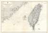
China Sea. Formosa I. and Strait. From Various Admiralty Surveys 1843 - 1904. Formosa and the Pescadores Is. from Japanese Government Surveys 1895 - 1909.
1929 (dated) 26.75 x 39.25 in (67.945 x 99.695 cm) 1 : 704000
1929 (dated) 26.75 x 39.25 in (67.945 x 99.695 cm) 1 : 704000
Description
This 1929 British Admiralty nautical chart or maritime map of Taiwan (Formosa) and the Taiwan Strait (Formosa Strait) details one of the world's most hotly disputed straits. The map embraces the entire island of Taiwan, the Penghu Islands (Pescadores), and part of the Fujian coast of China. Taiwan exhibits a surprising amount of inland detail for a nautical chart, including roads, cities, towns, villages, and detailed topography. In China proper, inland detail does not extend beyond the coastline and is limited to rivers and some high points. Yellow manuscript notations mark coastal lights and beacons.
Publication History and Census
This map was created by the British Admiralty and originally published in 1907 under the superintendence of Arthur Mostyn Field. The map was subsequently updated several times, with the present example dating to 1929. Examples of every edition of this chart are rare. We have been unable to locate any other examples of the 1929 edition and only three examples (each representing a different edition) are cataloged in OCLC.CartographerS
The British Admiralty Office (1795 - Present) or the United Kingdom Hydrographic Office refers to the Branch of the English government that is responsible for the command of the British Navy. In 1795 King George III created the United Kingdom Hydrographic Office, known in short as the U.K.H.O., to provide top notch nautical charts to the vast Royal Navy. Prior the founding of the Admiralty the surveying and creation of nautical charts was primarily a commercial venture wherein the cartographer himself, more of than not, actually financed the printing of his own material. The great navigator Cook himself is known to have scrambled for funds to publish his own seminal charts - the most important and advanced of the period. The system of privately funded nautical mapping and publishing left vast portions of the world uncharted and many excellent charts unpublished. King George III, responding significant loss in trade revenue related to shipwrecks and delay due to poor charts, recognized the need for an institutionalized government sponsored cartographic agency - the Admiralty. The first head of the Admiralty, a position known as Hydrographer, was the important cartographer Alexander Dalrymple. Dalrymple started by organizing and cataloging obtainable charts before initiating the laborious process of updating them and filling in the blanks. The first official Admiralty Chart appeared in 1800 and detailed Quiberon Bay in Brittany. By 1808 the position of Hydrographer fell to Captain Thomas Hurd. Hurd advocated the sale of Admiralty charts to the general public and, by the time he retired in 1829, had issued and published some 736 charts. Stewardship of the organization then passed to Rear Admiral Sir Francis Beaufort. It was under Beaufort's administration that the Admiralty truly developed as a "chart making" as opposed to a "chart cataloging" institution. Beaufort held his post from 1829 to 1854. In his 25 years at the Admiralty Beaufort created nearly 1500 new charts and sponsored countless surveying and scientific expeditions - including the 1831 to 1836 voyage of the H.M.S. Beagle. By 1855 the Admiralty's chart catalog listed some 1,981 charts. More by this mapmaker...
Arthur Mostyn Field (June 27, 1855 - July 3, 1950) was a senior officer in the Royal Navy and from 1904 - 1909 served as Hydrographer of the Navy. Born in Braybrooke, Field joined the Royal Navy in December 1868. He was promoted to lieutenant on October 15, 1875. In 1876, Field was appointed to the Fawn, a surveying ship captained by W.J.L. Wharton (who would become Hydrographer of the Navy in 1884). They undertook surveying missions in the Mediterranean, Red Sea, and off the east coast of Africa. Field remained with the Fawn until 1881, when he was assigned to survey the Oil River on the west coast of Africa. Field joined Wharton on the 1882 mission to survey the Straits of Magellan and the Rio de la Plata as his senior assistant. In 1885 Field received his first command, the HMS Dart, and spent more than the next four years surveying the coasts of Australia, including the Great Barrier Reefs and the coast of Queensland. These surveys were viewed very highly and his work off the coast of Australia earned him a promotion to Commander in June 1889. Field continued in his naval career, earning several shore and sea appointments. He was promoted to Captain on June 30, 1895, and commanded the HMS Penguin around Australia and the South Pacific, until 1898, when he was called back to home waters to conduct surveys. He succeeded W.J.L. Wharton as Hydrographer of the Navy in 1904 and served in that position until 1909. Field was promoted to Rear-Admiral in 1906 and to Vice-Admiral in 1910, when he was appointed Acting Conservator of the River Mersey, a position he held until 1930. Field died at the age of ninety-five on July 3, 1950. He married Laura Mary Hale in 1894, with whom he had one son, Thomas Mostyn Field, who followed his father into the Royal Navy and died aboard the HMS Queen Mary during the Battle of Jutland on May 31, 1916. Learn More...
Condition
Very good. Even overall toning. Exhibits light soiling.