This item has been sold, but you can get on the Waitlist to be notified if another example becomes available, or purchase a digital scan.
1870 Le Gendre Map of Taiwan or Formosa
FormosaTaiwan-gendre-1870-2$400.00

Title
Formosa Island and the Pescadores China.
1870 (dated) 20.5 x 20.5 in (52.07 x 52.07 cm) 1 : 875000
1870 (dated) 20.5 x 20.5 in (52.07 x 52.07 cm) 1 : 875000
Description
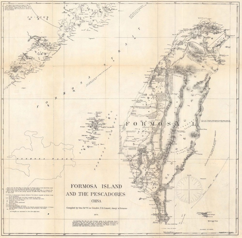
An interesting, important, and uncommon map of Taiwan or Formosa issued in 1870 by the American Consul at Amoy, Charles W. Le Gendre. This map represents the only detailed survey of Taiwan's interior prior to the Japanese invasion. It was issued in the wake of the tragic Rover Incident (see below), but more accurately reflects American interest in Formosa as a naval supply hub in the China Sea. It formed the basis of most subsequent maps of Taiwan's interior until the Japanese surveys of the 1890s.
A Closer Look
Focusing on the island of Formosa, this map covers from Fu-Kyen (Fukien), China to Botel Tobago. Includes the Pang-Hoo-Ting Island, undersea features such as the Formosa Bank, and more inland detail than any map of Formosa previously published.Rover Incident
This map originated with the unfortunate Rover Incident. The Rover was an American fishing vessel that shipwrecked in southern Formosa. Though the crew of the Rover was killed by the Taiwanese aboriginal population, it was widely assumed that they were alive and being held for ransom in the southern part of the Island. Le Gendre petitioned for and was granted the right to take an armed expedition into the region in the hopes of recovering the Americans. Though none of the Rover's crew remained alive, Le Gendre did succeed in producing the most sophisticated western map of the interior of Taiwan or Formosa to date. Though ostensibly a rescue mission, his study of Formosa is clearly laid out with commerce in mind, for his notes sugar growing regions, mineral (particularly coal) supplies, camphor districts, and woodlands are profuse. In the age of great steamships, coal was of particular interest as the U.S. needed a coal supply station in the China Sea. It was known that the mountainous interior of Taiwan held considerable supplies of the precious commodity, and part of Le Gendre's expedition involved finding ways to exploit it.East vs. West Taiwan
Reviewing this map, note the detail of western Taiwan as opposed to the relative emptiness of the eastern part of the island. At this time, western Taiwan was a colony of the Fukien Chinese, just across the Formosa Strait. Their border extended inland to Taiwan's Central Range. Beyond the Central Range was a little-known highland populated by diverse and often aggressively territorial aboriginal groups. The unique configuration of Le Gendre's Central Range, two large mountain chains embracing y an empty 'unexplored zone' makes its first appearance here, but was replicated on many subsequent maps; including British Admiralty Charts, well into the 1960s. This map was drawn by C. W. Le Gendre and engraved by Julius Bien of New York for publication in Le Gendre's 1874 Notes of Travel in Formosa.CartographerS
Charles William (Guillaum) Joseph Émile Le Gendre (August 26, 1830 - September 1, 1899) was a French-American diplomat active in East Asia during the second part of the 20th century. Born in Ouillins, France, Le Gendres came from a well connect family and attended both the Royal College of Rheims and the University of Paris. Around 1854 Le Gendre married an American, Clara Victoria Mulock (daughter of William Murlock) and moved to New York. During the American Civil War he served honorably and, despite being gravely wounded and losing an eye, rose rapidly in rank. He was discharged in 1864 with the brevet title of Brigadier General. Shortly following the 1865 close of the War, Le Gendre was dispatched as the American consul to Amoy China, in charge of the port cities of Amoy, Keelung, Taiwanfoo, Tamsui, and Takao. In this position Le Gendre traveled extensively throughout the region, earning the respect of authorities both in China and America. When the crew of an American fishing vessel, the Rover, was killed by Taiwanese aborigines following a shipwreck in southern Formosa, Le Gendre traveled to Taiwan. While his general purpose was to ransom presumed hostages from the Rover as well as prevent future hostilities, his secondary mission was to reconnoiter the island for trade. His detailed mappings for Formosa were by far the most advanced to date and were used in government issue charts well into the 1960s. In 1872 Le Gendre resigned his post as American Consul to take a position in the service of the Emperor of Japan, becoming the first foreigner to be employed in a Japanese government position. Le Gendre remained in the position until 1890 when he left Japan for Korea, where he took another advisory post. He held a position with the King of Korea until his death in Seoul on September 1 of 1899. More by this mapmaker...
Julius (Julien) Bien (September 27, 1826 - December 21, 1909) was a German-Jewish lithographer and engraver based in New York City. Bien was born in Naumburg, Germany. He was educated at the Academy of Fine Arts, Cassell and at Städel's Institute, Frankfurt-am-Main. Following the suppression of the anti-autocratic German Revolutions of 1848, Bien, who participated in the pan-German movement, found himself out of favor in his home country and joined the mass German immigration to the United States. Bien can be found in New York as early as 1849. He established the New York Lithographing, Engraving & Printing Company in New York that focused on the emergent chromo-lithograph process - a method of printing color using lithographic plates. His work drew the attention of the U.S. Government Printing Office which contracted him to produce countless government maps and surveys, including the Pacific Railroad Surveys, the census, numerous coast surveys, and various maps relating to the American Civil War. Bien also issued several atlases both privately and in conjunction with a relation, Joseph Bien. At the height of his career Bien was elected president of the American Lithographers Association. After his death in 1909, Bien's firm was taken over by his son who promptly ran it into insolvency. The firm was sold to Sheldon Franklin, who, as part of the deal, retained the right to publish under the Julius Bien imprint. In addition to his work as a printer, Bien was active in the New York German Jewish community. He was director of the New York Hebrew Technical Institute, the New York Hebrew Orphan Asylum, and president of the B'nai B'rith Order. Learn More...
Source
Le Gendre, C. W., Notes of Travel in Formosa, (Washington: Government Printing Office) vol 4, 1874.
Condition
Good. Backed on archival tissue for stability. Small areas of infill.
References
OCLC 1291435537. Library of Congress, G7910 1870 .L3 Vault (Le Gendre's original manuscript).