
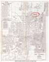
1947 Dolph City Plan or Map of Fort Lauderdale, Florida

This item has been sold.
Map of Fort Lauderdale Florida and Environs.
Poultry in Ft. Lauderdale.
- Digital Map Information
- Suitable for large format printing
- Full resolution TIFF file
- ICC color profile embedded
- Delivered instantly via download link
Poultry in Ft. Lauderdale.
This is a c. 1947 Dolph Map Company city plan or map of Fort Lauderdale, Florida. The map depicts from Northeast 56th Street south to the Broward County International Airport (now Fort Lauderdale-Hollywood International Airport) and from Federal Highway 441 east to the Atlantic Ocean. Schools, hospitals, parks, shopping centers, and a handful of government buildings are labeled. The Florida East Coast Railroad line cuts through the center of town. The most eye-catching detail is the red overprinting emphasizing the location of the Oakland Park Poultry Farm.Dating the Map
While the Oakland Park Poultry Farm would be a good way to date this piece, the proposed Fort Lauderdale Municipal Airport proved to be the best indicator. The airfield was built in 1941 to train navy pilots during World War II. In 1947, the federal government deeded the airport to the city of Fort Lauderdale.Publication History and Census
This map was created by the Dolph Map Company and published c. 1947 as a promotional piece for the Oakland Park Poultry Farm. We have been unable to locate any other surviving examples.Cartographer
Frank B. Dolph (October 3, 1897 - November 26, 1975) was an American businessman and map publisher. Born in Great Neck, Long Island, New York, Dolph served as a Navy storekeeper during World War I. He began selling maps in 1919 after returning from England, likely for the George F. Cram Company, where he ultimately became an administrative aide. He also worked for the Rand McNally Company for some time before he founded his own map publishing firm, Dolph and Stewart, with his friend, sometime in the 1920s. Dolph and Stewart made maps throughout the 1920s and 1930s until they sold the firm in 1945 when Dolph decided to return to Florida. Dolph opened a new map publishing business, the Frank B. Dolph Map Co. in Ft. Lauderdale and published city plans of cities throughout the United States. Many of his maps were distributed by Chambers of Commerce or sold at newsstands. Real estate developers greatly appreciated his maps, those published by both the Dolph and Stewart Company and the Frank B. Dolph Company. Dolph retired as president of his firm around 1965, when he handed the business off to his son, Frank B. Dolph, Jr. Dolph worked with cartographer Theodore M. Politano for decades while operating the Frank B. Dolph Map Company. Further Details...
Condition
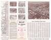
Very good. Exhibits light wear along original fold lines. Exhibits a handful of manuscript notations. Text and map of surrounding area on verso.