
This item below is out of stock, but another example (left) is available. To view the available item, click "Details."
Details
1862 Mitchell Map of the United States w/Confederate Arizona
$350.00
1862 Mitchell Map of the United States w/Confederate Arizona
UnitedStates-mitchell-1862$150.00

Title
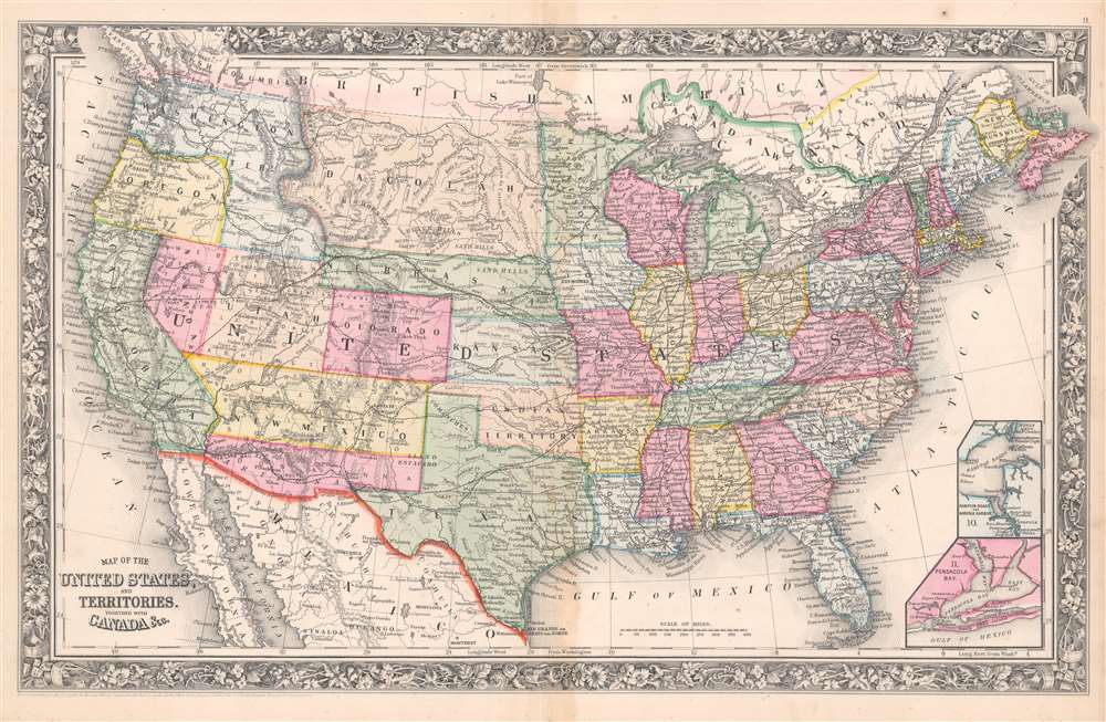
Map of the United States and Territories. Together with Canada etc.
1862 (undated) 13.75 x 21.5 in (34.925 x 54.61 cm) 1 : 10000000
1862 (undated) 13.75 x 21.5 in (34.925 x 54.61 cm) 1 : 10000000
Description
This is an 1862 Samuel Augustus Mitchell, Jr. map of the United States during the second year of the American Civil War (1861 - 1865). Notably, this map illustrates the ephemeral Confederate Arizona Territory and is one of the first maps to include the newly formed Colorado Territory and Dakota Territory. Depicting the continental United States from the Pacific Ocean to the Atlantic Ocean and from Canada to Mexico and the Gulf of Mexico, this map captures the unique and volatile nature of the year 1862.
At the beginning of the Civil War, support for the Confederacy ran high in the southern parts of the New Mexico Territory. Local concerns drove this sentiment, including a belief that the war would lead to an insufficient number of Federal troops to protect the citizens from the Apache, while others simply felt neglected by the government in Washington. Also, the Butterfield Overland Mail Route (an overland mail and stagecoach route from Memphis and St. Louis to San Francisco) was closed in 1861, depriving the people of Arizona of their connection to California and the East Coast.
These factors led to the people of the southern New Mexico Territory, or the Arizona Territory, to formally call for secession, and a convention adopted a secession ordinance on March 16, 1861, with a subsequent ordinance ratified on March 28, establishing the provisional territorial government of the Confederate 'Territory of Arizona'. The Confederate Arizona Territory was officially proclaimed on August 1, 1861, following Lieutenant-Colonel J. R. Baylor's victory over Union forces in the First Battle of Mesilla, and the territory was officially recognized by the government of the Confederacy on February 14, 1862. However, by July 1862, Union forces from California, known as the 'California Column' were marching on the territorial capital of Mesilla. Sent to protect California from a possible Confederate incursion, the 'California Column' drove Confederate forces out of the city, allowing them to retreat to Franklin, Texas. The territorial government fled as well and spent the rest of the war in 'exile'. First, they retreated to Franklin, then, after Confederate forces abandoned Franklin and all of West Texas, to San Antonio, where the 'government-in-exile' would spend the rest of the war. Confederate units from Arizona would fight for the rest of the war, and the delegate from Arizona attended both the First and Second Confederate Congresses.
Inset Maps
Another example of how this map reflects the volatility of life in the United States in 1862 is the addition of an inset map of Hampton Roads and Norfolk Harbor and a second inset map of Pensacola Bay in the lower right corner. Both areas witnessed critical battles during the American Civil War. The naval battle between the USS Monitor and the CSS Merrimac (the first naval battle between iron clad ships) took place at Hampton Roads on March 8 - 9, 1862. Fighting at Pensacola lasted from January 8, 1861, until November 23, 1861, with almost daily exchanges of cannon fire between Union and Confederate forces. Sporadic exchanges continued until the Confederates abandoned Pensacola after the Union capture of New Orleans.Confederate Arizona
Confederate Arizona was a territory claimed by the Confederate States of America from 1861 until 1865. The idea for an Arizona Territory appears as early as 1856, when the government of the Territory of New Mexico began to express concerns about effectively governing the southern part of the territory, as it was separated from Santa Fe by the Jornada del Muerto, a particularly unforgiving stretch of desert. The New Mexico territorial legislature acted on these concerns in February 1858, approving a resolution in favor of creating an Arizona Territory, with an east-west running border to be defined along the 32nd parallel. Impatiently waiting for Congress to approve the creation of the new territory, 31 delegates met at a convention in Tucson in April 1860 and drafted a constitution for the 'Territory of Arizona', which was to be organized out of the New Mexico Territory below 34th parallel. The convention elected a territorial governor and a delegate to Congress. Congress, however, was reluctant to act. Anti-slavery Representatives knew that the proposed territory was located below the line of demarcation set forth by the Missouri Compromise for the creation of new slave and free states, and they were not inclined to create yet another slave state. Thus, Congress never ratified the proceedings of the Tucson convention, and the Provisional Territory was never considered a legal entity.At the beginning of the Civil War, support for the Confederacy ran high in the southern parts of the New Mexico Territory. Local concerns drove this sentiment, including a belief that the war would lead to an insufficient number of Federal troops to protect the citizens from the Apache, while others simply felt neglected by the government in Washington. Also, the Butterfield Overland Mail Route (an overland mail and stagecoach route from Memphis and St. Louis to San Francisco) was closed in 1861, depriving the people of Arizona of their connection to California and the East Coast.
These factors led to the people of the southern New Mexico Territory, or the Arizona Territory, to formally call for secession, and a convention adopted a secession ordinance on March 16, 1861, with a subsequent ordinance ratified on March 28, establishing the provisional territorial government of the Confederate 'Territory of Arizona'. The Confederate Arizona Territory was officially proclaimed on August 1, 1861, following Lieutenant-Colonel J. R. Baylor's victory over Union forces in the First Battle of Mesilla, and the territory was officially recognized by the government of the Confederacy on February 14, 1862. However, by July 1862, Union forces from California, known as the 'California Column' were marching on the territorial capital of Mesilla. Sent to protect California from a possible Confederate incursion, the 'California Column' drove Confederate forces out of the city, allowing them to retreat to Franklin, Texas. The territorial government fled as well and spent the rest of the war in 'exile'. First, they retreated to Franklin, then, after Confederate forces abandoned Franklin and all of West Texas, to San Antonio, where the 'government-in-exile' would spend the rest of the war. Confederate units from Arizona would fight for the rest of the war, and the delegate from Arizona attended both the First and Second Confederate Congresses.
Territorial Changes in the northern Plains and the Second Mitchell map to depict Colorado
The year before, 1861, saw major territorial changes in the northern plains. The Kansas-Nebraska Act, signed on May 30, 1854, created the Nebraska Territory, which originally stretched from the 40th parallel to the 49th parallel and from the Continental Divide to the White Earth and Missouri Rivers. In 1861, however, both the Colorado territory (which was formed on February 28) and the Dakota Territory (created on March 2) were created out of land originally part of the Nebraska Territory. Nebraska's extended panhandle would be lost in 1863, with the formation of the Idaho Territory, which would also include all the land in the Washington Territory east of Washington State's modern-day border.Communication, Transportation and Other Notations
Aside from illustrating the historical events detailed in the proceeding paragraphs, this map contains numerous other important elements. One such is the route of the Pony Express, a transcontinental mail route consisting of 186 different 'stations' separated by ten miles operated by 120 riders and over 400 horses. Operating for eighteen months, the Pony Express was the main communication route to California after the beginning of the Civil War until October 24, 1861, when the first transcontinental telegraph was established. The rail network throughout the United States is also illustrated. Lines in operation in 1861 are illustrated by dark black lines, while proposed routes are indicated by dashed lines. Each of the proposed transcontinental routes are noted, nut none were completed until 1869. Both 'Canada East' (Quebec) and 'Canada West' (Ontario) are also labeled, along with New Brunswick, Nova Scotia, Prince Edward Island, and 'British America', or the rest of modern-day Canada. An inset map of Newfoundland is situated in the lower right corner. The whole is surrounded by Mitchell's distinctive flower border, common to Mitchell's atlases from 1860 - 1867.Publication History
This map was published by Samuel Augustus Mitchell, Jr. in the 1862 edition of his New General Atlas. Variations on the map appears form 1860 to the late 1880s, most of which were regularly updated to reflect fast-changing borders, political events, and infrastructure developments. As a whole, the set represents an invaluable record of the American Westward Expansion.Condition
Very good. Closed margin tears professionally repaired on verso.