This item has been sold, but you can get on the Waitlist to be notified if another example becomes available, or purchase a digital scan.
1950 Dolph City Plan or Map of Fort Myers, Florida
FortMyers-dolph-1950$87.50


Title
Map of Fort Myers Florida.
1950 (undated) 16.5 x 31.5 in (41.91 x 80.01 cm) 1 : 12672
1950 (undated) 16.5 x 31.5 in (41.91 x 80.01 cm) 1 : 12672
Description
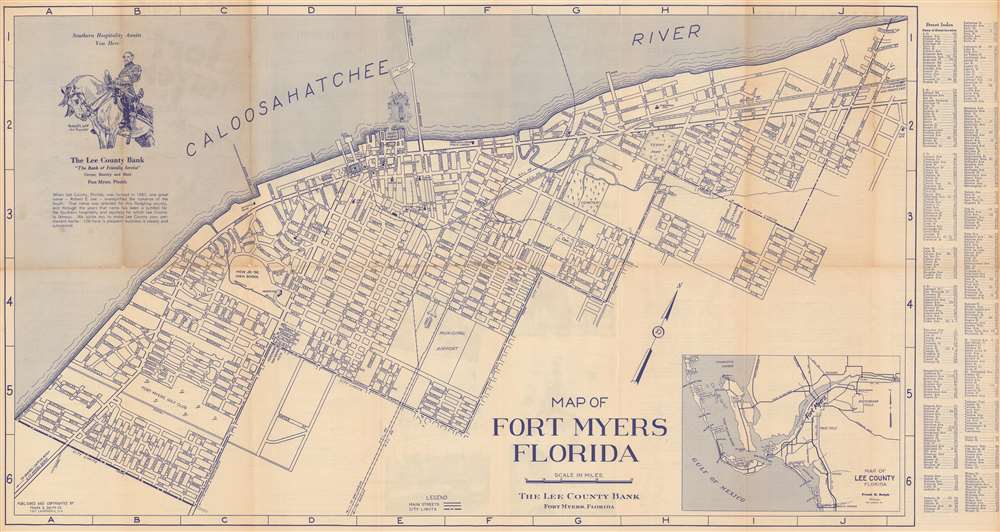
This is a 1950 Frank B. Dolph Company city plan or map of Fort Myers, Florida. Oriented toward the northwest, schools, parks, and streets are illustrated. Both the Atlantic Coast Line Railroad and the Seaboard Air Line Railroad tracks appear, with frieght and passenger terminals noted. The Lee County Bank distributed this map. An illustration of their central branch appears in the Caloosahatchee River. An inset map of Lee County, Florida appears in the lower right.
Publication History and Census
This map was created and published by the Frank B. Dolph Company and distributed by the Lee County Bank. We note a single cataloged example, located at Harvard University.Cartographer
Frank B. Dolph (October 3, 1897 - November 26, 1975) was an American businessman and map publisher. Born in Great Neck, Long Island, New York, Dolph served as a Navy storekeeper during World War I. He began selling maps in 1919 after returning from England, likely for the George F. Cram Company, where he ultimately became an administrative aide. He also worked for the Rand McNally Company for some time before he founded his own map publishing firm, Dolph and Stewart, with his friend, sometime in the 1920s. Dolph and Stewart made maps throughout the 1920s and 1930s until they sold the firm in 1945 when Dolph decided to return to Florida. Dolph opened a new map publishing business, the Frank B. Dolph Map Co. in Ft. Lauderdale and published city plans of cities throughout the United States. Many of his maps were distributed by Chambers of Commerce or sold at newsstands. Real estate developers greatly appreciated his maps, those published by both the Dolph and Stewart Company and the Frank B. Dolph Company. Dolph retired as president of his firm around 1965, when he handed the business off to his son, Frank B. Dolph, Jr. Dolph worked with cartographer Theodore M. Politano for decades while operating the Frank B. Dolph Map Company. More by this mapmaker...
Condition
Very good. Light wear and toning along original fold lines. Small areas of infill along original fold lines. Text and printed images on verso.
References
OCLC 70169199.