This item has been sold, but you can get on the Waitlist to be notified if another example becomes available, or purchase a digital scan.
1861 Sachse Bird's-Eye View Map of Fort Monroe, Virginia
FortressMonroe-sachse-1861$625.00

Title
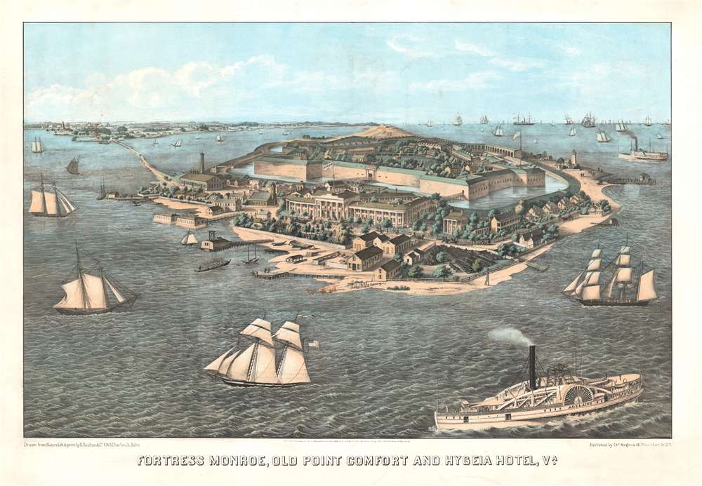
Fortress Monroe, Old Point Comfort and Hygeia Hotel, Va.
1861 (dated) 19.75 x 28.5 in (50.165 x 72.39 cm)
1861 (dated) 19.75 x 28.5 in (50.165 x 72.39 cm)
Description
This is an 1861 Edward Sasche bird's-eye view map of Fort Monroe, Virginia. Published at the beginning of the American Civil War (1861 - 1865), the view overlooks Fort Monroe from the southeast, with the Hygeia Hotel in the foreground. A moat surrounds the fort, with buildings and soldiers drilling within the fort. Sailing and steamships fill the Hampton Roads and Chesapeake Bay.
Old Point Comfort
Point Comfort was discovered and named by Jamestown colonists when they arrived in Virginia. Not long after the founding of Jamestown, colonists built defensive fortifications at Old Point Comfort. The wooden 1609 stockade Fort Algernourne was renamed Point Comfort Fort in 1612. Old Point Comfort was later where the British-owned Dutch-flagged privateer White Lion, arrived off the point and traded twenty to thirty African captives meant for Spanish colonies in exchange for supplies and work from the English colonists - recognized as the advent of slavery in colonial America. A fort known as Fort George stood on Old Point Comfort from 1728 until a 1749 hurricane destroyed its masonry walls. Nonetheless, the wooden buildings remained in use from around 1755 until at least 1775. British forces manned Old Point Comfort with artillery as Patriot and French forces approached Yorktown in 1781 and French forces occupied these batteries during the Siege of Yorktown, which ended the American Revolutionary War.Fort Monroe and Old Point Comfort
As a reaction to the War of 1812, President James Monroe's administration developed a new network of coastal defenses, known as the 'third system of U.S. fortifications'. Fort Monroe was the first installation in this new system and meant to be its headquarters. Built to defend Hampton Roads, construction on Fort Monroe began in 1819, with troops were first garrisoned by 1823, despite continuing construction for another twenty-five years.Fort Monroe and the American Civil War
Even though Fort Monroe is in Virginia, the Union held the fort throughout the war. After Virginia seceded in May, President Lincoln reinforced the fort. Fort Monroe served as the launching point for General George McClellan's Peninsula Campaign in 1862. and was an important supply point during General Ulysses S. Grant's siege of Petersburg. After the war, Confederate President Jefferson Davis was imprisoned at Fort Monroe for two years.Hygeia Hotel
Built in 1822, the first Hygeia Hotel provided housing for workers building Fort Monroe. Later, it housed engineers and officers before base housing was available. It eventually expanded to over 200 rooms and welcomed beach-vacationers. President Andrew Jackson and President John Tyler were among its guests and over 5,000 people stayed at the hotel in 1859. Over 10,000 guests enjoyed the Hygeia's hospitality in 1860. In 1862, the U.S. Secretary of War ordered the Hygeia Hotel torn down to eliminate civilian visitors to Fort Monroe (including potential Confederate spies) and to improve fields of fire from the fort towards the James River. A second Hygeia Hotel was built after the Civil War as a resort that could accommodate 1,000 guests. This hotel was torn down in 1902 after the Federal government revoked the hotel's land-rights in a plan to expand. However, the expansion plans never materialized and the land remains vacant.Publication History and Census
This view was drawn, lithographed, and printed by Edward Sachse and published by Charles Magnus in 1861. We note three examples cataloged in OCLC which are part of the collections at the Library of Congress, the Boston Athenaeum, the University of Michigan, and the Staatsbibliothek zu Berlin. We also note cataloged examples that are part of the collections at the Huntington Library and the National Museum of American History.CartographerS
Edward Sachse (1804 - 1873) was a German American artist, lithographer, and publisher. Born in Görlitz, Germany, Sachse operated a small lithographic firm and publishing house in Germany before immigrating to the United States in 1848. He settled in Baltimore, where he worked for E. Weber and Company briefly before opening his own firm, E. Sachse and Company, around 1850. During the 1850s, 1860s, and early 1870s, Sachse developed a reputation as the main lithographer of the Maryland - Washington D.C. area. One of his most recognizable accomplishments was the role he played in documenting the construction of the U.S. Capitol, along with other major building projects in Washington. He also created a massive twelve-sheet aerial view of Baltimore (which took three years and several artists to produce) and a four-sheet view of Syracuse. During the American Civil War, Sachse produced a series of lithographs of military campsites, hospitals, and barracks in Baltimore and Washington, D.C. Sachse sold these views at the bargain price of 25 cents to soldiers as souvenirs and often created multiple views of the same encampment when new regiments moved in, and the scenery, fortifications, and tents changed. Soldiers bought the prints and often mailed them home, sometimes with notes marking their specific tent. Sachse had a close working relationship with Charles Magnus (1826 - 1900), who published and sold many of Sachse's works. Sachse's firm also published advertising posters, book illustrations, labels, and business cards. More by this mapmaker...
Charles Magnus (1826 - 1900) was a New York City based stationer, illustrator, bookseller, and map and print publisher active in the middle to late 19th century. Magnus was born in Elberfeld, Germany, as Julian Carl Magnus. Fleeing the March Revolution in Germany, the Magnus family immigrated to New York City in 1848. In New York, Charles' brother Carl Emil had already established himself as the editor of a German weekly newspaper, Deutsche Schnellpost. It was through his brother that Magnus learnt the printing and publishing trade. The earliest work to bear the Magnus inscription dated to the 1850s and includes various pictorial broadsides and maps intended to commemorate important events - the most notable for map enthusiasts being his 1855 map of New York commemorating the '79th Year of Independence of the United States'. During the 1860s and years of the American Civil War, Magnus, through various political connections, became one of the few illustrators with unrestricted access to Union military camps. He is consequently particularly well known for his authentic view of Civil War cities, personages, and events. Following the war, Magnus began to develop a prosperous business creating and selling panoramic city views, song sheets, and patriotic envelopes. In all Charles Magnus, with over 1000 known works, was one of the most prolific American printers of broadsides and other lithographs. Learn More...
Condition
Very good. Light soiling. Closed margin tears professionally repaired on verso. Wide margins.
References
OCLC 11442485, 191909210, 1286696349, 1291412515.