1944 Army Information Branch Newsmap of the Approaches to Japan
FourApproaches-newsmap-1944-2$275.00


Title
Four Approaches to Japan. Volume III No. 3B / NEWSMAP. For the Armed Forces. 243rd Week of the War - 125th Week of U.S. Participation. Volume III No. 3F.
1944 (dated) 35 x 47 in (88.9 x 119.38 cm)
1944 (dated) 35 x 47 in (88.9 x 119.38 cm)
Description
This is a 1944 Army Information Branch double-sided Newsmap for the week of April 27 to May 4, 1944. It was issued on May 8, 1944. One side of the map features four Richard Edes Harrison map views depicting the four approaches to Japan. The other includes information and photographs from both the Italian and Pacific campaigns and a map depicting the pre-invasion air offensive undertaken by the Allies, which presents continental Europe from England and Spain to Leningrad and the Black Sea and from Oslo and the North Sea to Naples, Greece, and Turkey.
The photographs printed here come from the Italian and Pacific theaters. The three images along the left border were taken in Italy; the top one on the Anzio Beachhead, the second features a captured German remote-controlled miniature tank that had been disabled by machine gun fire, and the third depicts a U.S. Army barber somewhere in Italy, who has several different cuts available, including a Saturday special, 'shave, haircut, and purple-heart'. The other photographs, along the bottom, come from the Pacific. The image of the fleet was taken in the Marshall Islands includes nine aircraft carriers and a dozen battleships, cruisers, destroyers, and supply ships. The other three images illustrate jungle combat on the islands. The photograph of the soldier was taken on Bougainville Island, while a location is not given for the other two. The larger of the three images depicts a pontoon bridge built by the Army Engineers after the local bridge had been washed away by a flood.
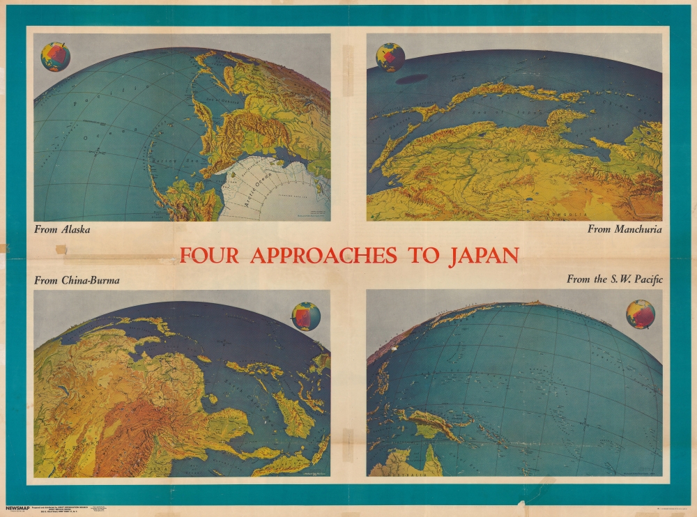
The Four Approaches to Japan
Concerning the Four Approaches to Japan, each map measures 12.5 x 20 inches and depict topography on a spherical Earth - a novel and captivating cartographic convention pioneered by Harrison. The four titles are 'From Alaska', 'From Manchuria', 'From China-Burm'a, and 'From the S.W. Pacific'. Although these maps do not include notations detailing combat actions, all four views cover fiercely contested regions. Richard Edes Harrison is credited with bringing a fresh perspective to cartography, as he was not a trained cartographer. He compiled his maps from various sources and is credited for pioneering this type of spherical view, which allows for a much better understanding of actual distances in the light of air travel.The Newsmap
The other side of the map presents detailed information about the war's progress over the previous week. Information about the far-flung air offensive over Europe is the first story, stating that targets have ranged from Oslo to Ploesti in Romania. Raids had been undertaken from Allied bases in both England and Italy against an extensive list of targets over the previous month. In Italy, fierce fighting in Anzio continued until Rome's capture in early June. In the Central Pacific, the Pacific Fleet led another raid on Truk Island in the Carolines. Truk was one of Japan's major forward operating bases in the Pacific and would prove to be a tough assignment. The Pacific Command, led by Admiral Chester Nimitz, decided to 'leapfrog' Truk and let it 'wither on the vine' as Allied naval attacks took a toll on Japanese shipping, opting to launch their next campaign in the Mariana Islands. Japanese military units were surrounded and stranded throughout the Pacific, as was done in the offensive on New Guinea, which is related in the section discussing the Southwest Pacific. These soldiers were left to either starve or die of disease since they did not choose to surrender. The sections covering Southeast Asia and the Eastern Front are far less detailed, although two different engagements are recounted in the Southeast Asian theater. Heavy fighting was reported around Imphal in India and along the Mandalay-Myitkyina railway in Burma. The right map details continental Europe. Rail lines and the two different zones of the air offensive are illustrated: England and Italy.The photographs printed here come from the Italian and Pacific theaters. The three images along the left border were taken in Italy; the top one on the Anzio Beachhead, the second features a captured German remote-controlled miniature tank that had been disabled by machine gun fire, and the third depicts a U.S. Army barber somewhere in Italy, who has several different cuts available, including a Saturday special, 'shave, haircut, and purple-heart'. The other photographs, along the bottom, come from the Pacific. The image of the fleet was taken in the Marshall Islands includes nine aircraft carriers and a dozen battleships, cruisers, destroyers, and supply ships. The other three images illustrate jungle combat on the islands. The photograph of the soldier was taken on Bougainville Island, while a location is not given for the other two. The larger of the three images depicts a pontoon bridge built by the Army Engineers after the local bridge had been washed away by a flood.
Publication History and Census
This map was prepared and distributed by the Army Information Branch from public sources of information. It was distributed in the Navy by the Educational Services Section and was published on May 8, 1944. We note 7 examples of the Newsmap cataloged in OCLC, which are part of the collections at Duke University, Denison University, Ohio Wesleyan University, Davidson College, Southern Illinois University at Edwardsville, the University of Missouri - Columbia, and the National Library of Australia. Another example is part of the collection at the University of North Texas.Cartographer
Richard Edes Harrison (1902 - January 5, 1994) was an American cartographer and cartoonist active in the middle part of the 20th century. Harrison is credited with redefining cartography, especially journalistic cartography, by employing spherical perspective, bold shading, and graphic design to both make maps more publicly accessible and give them an artistic dimension. Harrison was born in Baltimore and studied design at Yale, graduating in 1923, before relocating to New York City at the height of the Great Depression. He made ends meet through industrial design work, creating everything from bottles to ashtrays. His first foray into the cartographic world was a fill-in job at Fortune magazine. The editors at Fortune must have admired his work for it launched a long-standing collaboration. His work, doubtless inspired by the age of air travel, became exceptionally popular during World War II, where his unique approach and political charged subject matter illustrated the seats of war with exceptional poignancy and clarity. After the war, Harrison continued to produce maps from his base in New York City. In his spare time he was an avid ornithologist and was commonly seen in Central Park in search of rare bird sightings. More by this mapmaker...
Source
Newsmap series.
Newsmaps were published weekly between April 1942 and March 1946. Their content usually featured world maps, short summaries of the week’s military action, and photographs of troops and materiel. Early Newsmaps were printed on one side only, but, later in the war, they were printed on both sides, with the reverse bearing large-format maps, photographs, or other visual information. Several different versions of Newsmaps were produced: a large domestic version, a smaller overseas version, and an industrial version, which included more information about war production efforts. Two other editions appear in the United States Government Publications Monthly Catalogs, a 'Newsmap Special Edition' and a 'Newsmap Special Supplement for Special Training Units'.
Per the National Archives and Records Administration, ‘NEWSMAPS were not issued for general distribution. The posters were distributed to military installations, government and civilian groups working on War Department projects, and certain depository libraries, as designate by Congress, and one copy to Congressmen, if requested.’ The importance of the Newsmaps to the Army is related in the 1944 Basic Field Manual for The Special Service Company. The Manual states that as soon as the company reaches its destination ‘the company commander should contact the Special Service Branch in theater of operations headquarters, for copies of the weekly Newsmap.’ Also per the Manual
Per the National Archives and Records Administration, ‘NEWSMAPS were not issued for general distribution. The posters were distributed to military installations, government and civilian groups working on War Department projects, and certain depository libraries, as designate by Congress, and one copy to Congressmen, if requested.’ The importance of the Newsmaps to the Army is related in the 1944 Basic Field Manual for The Special Service Company. The Manual states that as soon as the company reaches its destination ‘the company commander should contact the Special Service Branch in theater of operations headquarters, for copies of the weekly Newsmap.’ Also per the Manual
The librarian should check the weekly Newsmap as soon as it is made available and should post it in a conspicuous place. He should take steps to see that the place where the Newsmap is posted is made known to all troops of the area in which the company or platoon is operating. This can be done effectively through notices in soldier newspapers, verbal announcements by those directly in charge of troops, and by posting announcements on bulletin boards.
Condition
Fair. Wear along original fold lines and slight loss at fold intersections. Closed tear extending 2.75 inches into printed area from bottom margin professionally repaired on verso. Verso repairs to fold separations. Closed margin tears professionally repaired on verso. Old tape reside on recto. Two pieces of old tape still adhered to recto.
References
University of North Texas Archival Research Key ark:/67531/metadc898. Government Documents No. W 109.207:3/3. OCLC 62596895.