This item has been sold, but you can get on the Waitlist to be notified if another example becomes available, or purchase a digital scan.
1747 Bowen Map of France
France-bowen-1747$150.00

Title
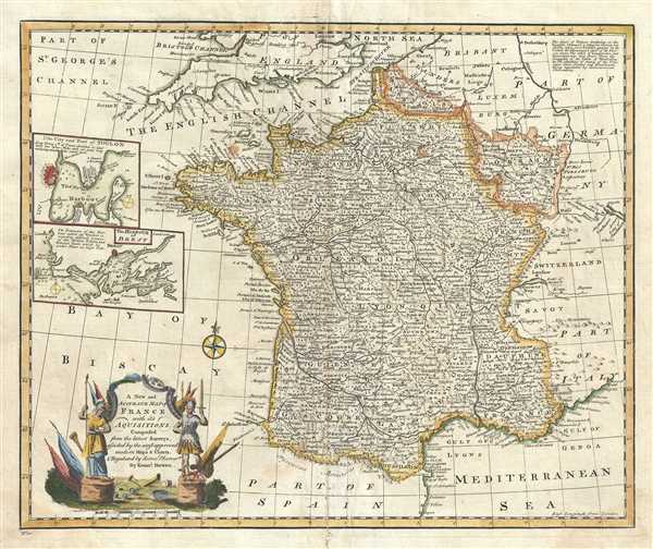
A New and Accurate map of France with its Acquisitions.
1747 (undated) 15 x 18 in (38.1 x 45.72 cm) 1 : 3300000
1747 (undated) 15 x 18 in (38.1 x 45.72 cm) 1 : 3300000
Description
A beautiful example of Emanuel Bowen’s 1747 map of France. The map depicts the entire Kingdom of France including the newly acquired regions of Lorraine and Artois. The map renders the entire region in extraordinary detail, noting mountains, rivers, roads, lakes, cities and other topographical features. Two insets along the left border detail the Harbor of Brest and the City and Port of Toulon. A short paragraph in the top right quadrant describes the English Channel and the Coast of France. A decorative title cartouche appears in the lower left quadrant. This map was prepared by Emanuel Bowen as plate no. 10 for the 1747 issue of A Complete System of Geography.
Cartographer
Emanuel Bowen (1694 - May 8, 1767) had the high distinction to be named Royal Mapmaker to both to King George II of England and Louis XV of France. Bowen was born in Talley, Carmarthen, Wales, to a distinguished but not noble family. He apprenticed to Charles Price, Merchant Taylor, from 1709. He was admitted to the Merchant Taylors Livery Company on October 3, 1716, but had been active in London from about 1714. A early as 1726 he was noted as one of the leading London engravers. Bowen is highly regarded for producing some of the largest, most detailed, most accurate and most attractive maps of his era. He is known to have worked with most British cartographic figures of the period including Herman Moll and John Owen. Among his multiple apprentices, the most notable were Thomas Kitchin, Thomas Jeffreys, and John Lodge. Another apprentice, John Oakman (1748 - 1793) who had an affair with and eventually married, Bowen's daughter. Other Bowen apprentices include Thomas Buss, John Pryer, Samuel Lyne, his son Thomas Bowen, and William Fowler. Despite achieving peer respect, renown, and royal patronage, Bowen, like many cartographers, died in poverty. Upon Emanuel Bowen's death, his cartographic work was taken over by his son, Thomas Bowen (1733 - 1790) who also died in poverty. More by this mapmaker...
Source
Bowen, E., A Complete System of Geography. Being a description of all the countries, islands, cities, chief towns, harbours, lakes, and rivers, mountains, mines, etc., of the known world …, (London) 1747.
Condition
Very good. Some damage with verso repair along original centerfold. Minor creasing along height of map near centerfold. Minor spotting.
References
Rumsey 3733.009. OCLC: 49669270.