
This item below is out of stock, but another example (left) is available. To view the available item, click "Details."
Details
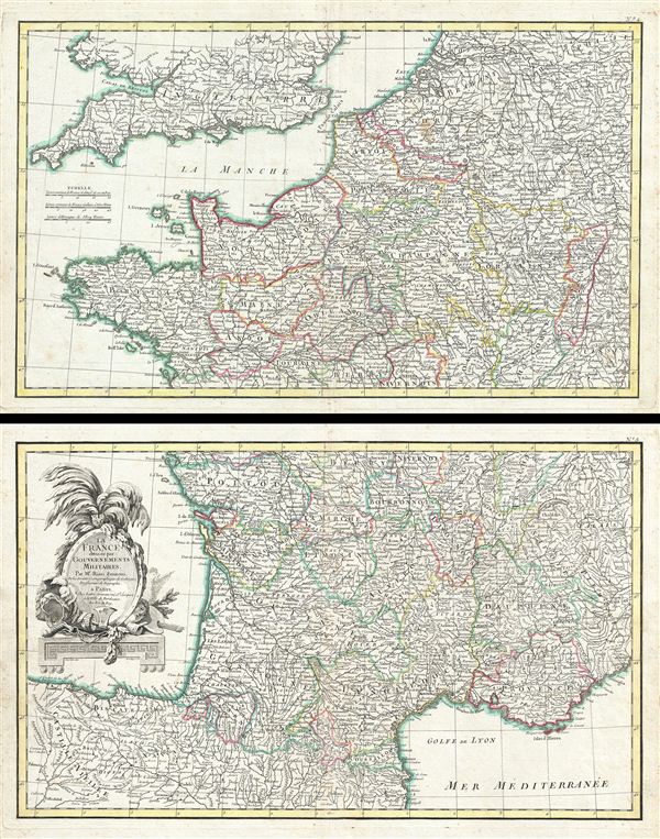
1775 Zannoni Two Panel Map of France
1775 (undated) $250.00
1783 Zannoni Map of France (2 panels)
France-zannoni-1783$175.00

Title
La France divisee par Gouvernements Militaires.
1783 (undated) 26 x 20.5 in (66.04 x 52.07 cm)
1783 (undated) 26 x 20.5 in (66.04 x 52.07 cm)
Description
A beautiful example of Zannoni's 1783 decorative two panel map of France. The lower sheet covers from Valladolid, Spain, eastwards as far as Piedmont and northwards to Navernois. The northern sheet covers from Bretagne eastward as far as Switzerland and northwards to the Hague. This map also includes the Channel Islands and the southern Part of england and Wales.
France at this time was under the reign of Louis XVI, the last Ancien Regime French King before the French Revolution. Louis XVI was probably not the worse king France ever had, but he was definitely in the wrong place at the wrong time. In the years just prior to the 1889 French Revolution, France had entered a period of sustained economic decline. French in involvement in the American Revolutionary War and the Seven Years War strained the national treasury and put increased pressure on the peasantry. This was compounded by several years of poor harvest brought on by erratic weather patterns associated with el Nino and the 1783 eruptions the Icelandic Laki and Grimsvotn volcanoes. The Royal court at Versailles, isolated and seemingly indifferent to the hardships of the lower classes, proved an easy target. events came to a head on July 14th, 1789, when angry insurgents stormed the Bastille prison, giving birth to the bloody French Revolution and effectively ending the French monarchy.
A decorative title cartouche appears in the lower left quadrant of the lower plate. Drawn by Zannoni c. 1783 for issue as plate nos. 4-5 in Jean Lattre's 1783 issue of the Atlas Moderne.
CartographerS
Giovanni Antonio Bartolomeo Rizzi Zannoni (September 2, 1736 - May 20, 1814) was an 18th century Italian cartographer active in Venice and Naples. Zannoni was born in Padua, Italy on September 2, 1736. Between 1749 and 1751 Zannoni studied Astronomy at the University of Padua under John Polen, a prominent astronomer of the period. After leaving the University, Zannoni was commissioned by the King of Poland, Augustus III, to map that country. Zannoni's subsequent survey is considered the first accurate triangulation of Poland. Afterwards Zannoni's services were in high demand and he traveled around much of Europe, working on various surveys in Denmark, Germany, Prussia, and Sweden. Around 1757 Zannoni was caught up in the hostilities surrounding the Seven Year War and, after one battle, was taken to Paris as a prisoner of war. Paris must have suited Zannoni for he remained for nearly 20 years, even taking service with the Paris Engineer's Office. It was also here in Paris the Zannoni developed the cartographic contacts that would lead to his most prolific cartographic publications, including the Atlas Moderne in conjunction with Lattre. In 1781, Zannoni was called to Naples by the Bourbon monarchy to help in the revision of the Charter of 1769. Afterwards he stayed on and produced a numerous important maps of the Kingdom of Naples. Zannoni is considered a careful and precise cartographer and his work, particularly the maps he made in Naples, have been praised by R.V. Tooley as 'remarkable for a marvelously minute attention to detail, and amply deserves the commendation passed upon it by Sir George Fordham' (Tooley, Maps and Mapmakers, 21). Zannoni would spend the remainder of his days in Naples and passed away on May 20, 1814. More by this mapmaker...
Jean Lattré (170x - 178x) was a Paris based bookseller, engraver, globe maker, calligrapher, and map publisher active in the mid to late 18th century. Lattré published a large corpus of maps, globes, and atlases in conjunction with a number of other important French cartographic figures, including Janvier, Zannoni, Bonne and Delamarche. He is also known to have worked with other European cartographers such as William Faden of London and the Italian cartographer Santini. Map piracy and copyright violations were common in 18th century France. Paris court records indicate that Lattré brought charges against several other period map publishers, including fellow Frenchman Desnos and the Italian map engraver Zannoni, both of whom he accused of copying his work. Lattré likes trained his wife Madame Lattré (né Vérard), as an engraver, as a late 18th century trade card promotes the world of 'Lattré et son Epouse.' Lattré's offices and bookshop were located at 20 rue St. Jaques, Paris, France. Later in life he relocated to Bordeaux. Learn More...
Source
Lattre, Jean, Atlas Moderne ou Collection de Cartes sur Toutes les Parties du Globe Terrestre, c. 1783.
Condition
Very good condition. Original centerfold exhibits toning. Blank on verso. Platemark visible. Measurement indicates two panels.
References
Phillips (Atlases) 664. National Maritime Museum, 215.