This item has been sold, but you can get on the Waitlist to be notified if another example becomes available, or purchase a digital scan.
1830 Lapie Comparative Map of France in 1789 and 1813
FranceCompare17891813-lapie-1829$87.50

Title
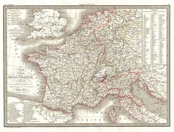
Carte Comparee de la France en 1789 et 1813.
1830 (dated) 16.5 x 22 in (41.91 x 55.88 cm)
1830 (dated) 16.5 x 22 in (41.91 x 55.88 cm)
Description
A fine first edition example of M. Lapie's 1830 comparative map of France in 1789 and 1813. Marking a period of historical significance, this map depicts the French empire both before and at the height of Napoleon's conquests. At its greatest extent Napoleon's French empire stretched eastward from the Atlantic to include all of Germany, Austria, and Northern Italy. The upper right corner of the map contains a table listing the departments of France and the Kingdom of Italy in 1813.
The substance of this map emerges through the color coding, which is defined by a key in the upper left quadrant. Coding defines the designated borders of France in 1789 and compares them to the expanded borders of 1813. It also delimits the departments of the Kingdom of Italy, the states of the Confederation of the Rhine, and the boundaries of Switzerland and neighboring states.
The French Revolution began in 1789 and resulted in the abolition of the French monarchy and its replacement with a radical democratic republic. In 1799, Napoleon Bonaparte staged a coup which led to Bonaparte's dictatorship and eventually (in 1804) to his proclamation as emperor, which marked the end of the republican phase of the French Revolution. The 1812 French invasion of Russia marked a turning point in Napoleon's fortunes and led to the defeat of his forces at the ‘Battle of the Nations' in 1813. In 1814, a coalition of european powers defeated France and forced Napoleon into exile on the island of elba.
This map was engraved by Armand Joseph Lallemand as plate no. 21 in the first edition of M. Lapie's important Atlas Universel. This map, like all maps from the Atlas Universel features an embossed stamp from the Lapie firm.
CartographerS
Pierre M. Lapie (fl. 1779 - 1850) and his son Alexandre Emile Lapie (fl. 1809 - 1850) were French cartographers and engravers active in the early part of the 19th century. The Lapies were commissioned officers in the French army holding the ranks of Colonel and Capitan, respectively. Alexander enjoyed the title of "First Geographer to the King", and this title appears on several of his atlases. Both father and son were exceptional engravers and fastidious cartographers. Working separately and jointly they published four important atlases, an 1811 Atlas of the French Empire (Alexander), the 1812 Atlas Classique et Universel (Pierre), the Atlas Universel de Geographie Ancienne et Modern (joint issue), and the 1848 Atlas Militaire (Alexander). They also issued many smaller maps and independent issues. All of these are products of exceptional beauty and detail. Despite producing many beautiful maps and atlases, the work of the Lapie family remains largely underappreciated by most modern collectors and map historians. The later 19th century cartographer A. H. Dufour claimed to be a student of Lapie, though it is unclear if he was referring to the father or the son. The work of the Lapie firm, with its precise engraving and informational density, strongly influenced the mid-19th century German commercial map publishers whose maps would eventually dominate the continental market. More by this mapmaker...
Armand Joseph Lallemand (c. 1810 - 1871) was an engraver and map publisher based in Paris during the mid-19th century. Most of Lallemand's work focused on landscapes and building vies, though he did take part in a few cartographic ventures, including the production of an atlas with Alexandre Emile Lapie and several tourist pocket maps of Paris. Learn More...
Source
Lapie, M., Atlas Universel de Geographie. Ancienne et Moderne, precede d'un Abrege de Geographic Physique et Historique…, 1829. (Rumsey identifies this as the first edition of Lapie's Atlas Universel. In all known examples, the title page is dated 1829 while the maps are dated variously to 1833 - suggesting that the first issue of this atlas was 1833, not 1829.)
Condition
Very good. Original platemark visible. Blank on verso. Original centerfold.
References
Rumsey 2174.021. Phillips (Atlases) 754, 765.