
This item below is out of stock, but another example (left) is available. To view the available item, click "Details."
Details
1844 Black Map of France in Departments
1844 (undated) $100.00
1851 Black Map of France in Departments
FranceDept-black-1851$50.00

Title
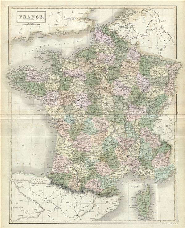
France in Departments.
1851 (undated) 20.5 x 17 in (52.07 x 43.18 cm)
1851 (undated) 20.5 x 17 in (52.07 x 43.18 cm)
Description
This is a fine example of Adam and Charles Black's 1851 map of France. The map covers France just prior to the December 2 1851 coup d'etat that brought about the Second empire. In less than a year, the Second Republic transformed into the Second empire, established by a referendum on November 7, 1852. President Louis-Napoleon Bonaparte, elected by the heavily Bonapartist French people, officially became Napoleon III, emperor of the French, from the symbolic and historic date of December 2, 1852. It covers from the Nord in the north to eastern Pyrenees in the south and from Finistere in the west to Upper and Lower Rhein in the east. An inset map near the lower right corner details Corsica.
The map divides France into its constituent Departments. The French Department system was established on March 4th, 1790 by the National Constituent Assembly to replace the provinces with what the Assembly deemed a more rational structure. They were designed to deliberately break up France's historical regions in an attempt to erase cultural differences and build a more homogeneous nation. Initially there were 83 departments but by 1800 that number increased to roughly 130. Many of the departments that were created in 1790 remain the administrative districts to this day. Nonetheless, the province system was so engrained that most cartographers felt obliged to include two maps of France in their atlases, one showing the current department system, and another defining the defunct provinces.
Various towns, cities, rivers, roads, railways, mountains and several other topographical details are noted with relief rendered by hachure. This map was engraved by Sidney Hall and issued as plate nos. XV and XVI for the 1851 edition of Black's General Atlas of the World.
CartographerS
Charles and Adam Black (fl. 1807 - present) were map and book publishers based in Edinburgh. Charles and his uncle, Adam, both of Edinburgh, Scotland, founded their publishing firm in 1807. They published a series of maps and atlases throughout the 19th century. In addition to an array of atlases, the Black firm is known for their editions of the Encyclopedia Britannica (1817 - 1826) and the first publishing of Sir Walter Scott's novels in 1854. In 1889 the A. & C. Black publishing house moved to London where it remains in operation to this day. More by this mapmaker...
Sidney Hall (1788 - 1831) was an English engraver and map publisher active in London during the late 18th and early 19th centuries. His earliest imprints, dating to about 1814, suggest a partnership with Michael Thomson, another prominent English map engraver. Hall engraved for most of the prominent London map publishers of his day, including Aaron Arrowsmith, William Faden, William Harwood, and John Thomson, among others. Hall is credited as being one of the earliest adopters of steel plate engraving, a technique that allowed for finer detail and larger print runs due to the exceptional hardness of the medium. Upon his early death - he was only in his 40s - Hall's business was inherited by his wife, Selina Hall, who continued to publish under the imprint, "S. Hall", presumably for continuity. The business eventually passed to Sidney and Selina's nephew Edward Weller, who became extremely prominent in his own right. Learn More...
Source
Black, A. and C., General Atlas Of The World, (Edinburgh) 1851.
Condition
Very good. Minor overall toning. Blank on verso. Minor foxing and offsetting. Verso repair on original centerfold.
References
Rumsey 2305.023 (1854 edition). Philips (atlases) 4334.