1638 Merian Plan of the Walled City of Franckenthal
Frankenthal-merian-1638$250.00

Title
Franckenthal.
1638 (undated) 8 x 12.5 in (20.32 x 31.75 cm)
1638 (undated) 8 x 12.5 in (20.32 x 31.75 cm)
Description
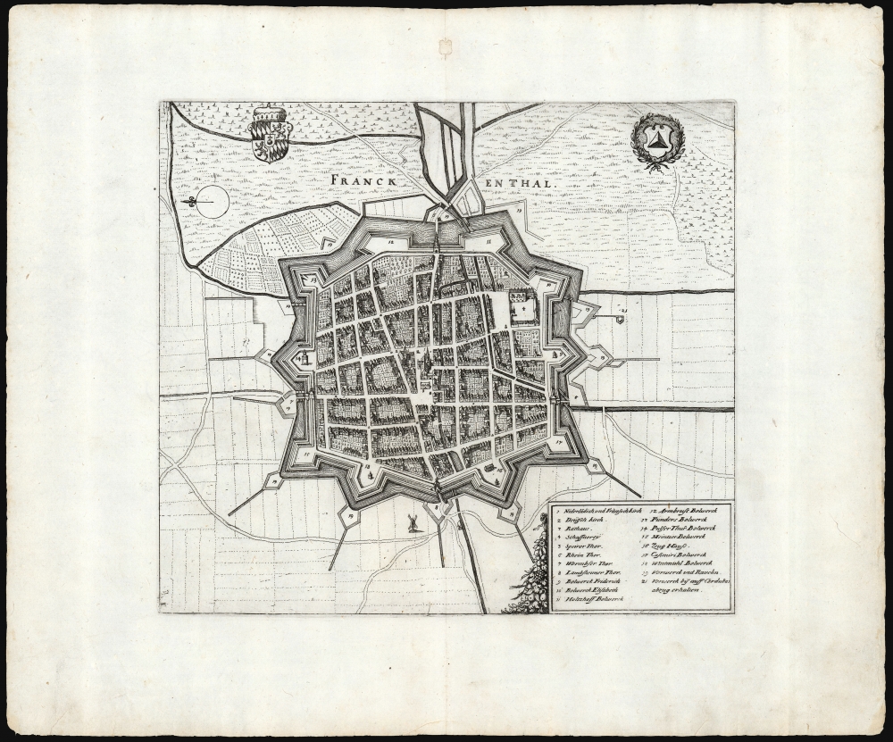
This is Matthäus Merian's superbly detailed 1638 plan of the fortress city of Franckenthal, as it stood during the Thirty Years' War (1618 - 1648). Included in Merian's 1638 Archontologia cosmica sive imperiorum, it accompanied views and plans of other fortresses and battles pertinent to the long war.
A Closer Look
The city and its distinctive bastions are sharply portrayed. 21 key structures - primarily churches and the bastions along the walls - are letter-keyed to a legend at the lower right of the view. Until the 16th century, the city was a fishing village and the site of an Augustinian monastery. After 1562 it passed to the Rhineland-Palitanate and was settled by Dutch Protestant refugees from the Eighty Years’ War (1568 - 1648). The descendants of those refugees would find their city a target during the Thirty Years' War. The city walls would not prevent the city from suffering heavily. It changed hands more than a few times and was practically laid waste. It was rebuilt in 1682, only to be burned to the ground in 1689 by French troops in the War of the Grand Alliance (1689 - 1697).Publication History and Census
This view was created by Matthaus Merian and appeared in his 1638 Archontologia cosmica. It may have been intended for inclusion in his 1633 Theatrum Europaeum, but we do not see it in digitized examples of that work. The separate plan is well represented in institutional collections.Cartographer
Matthäus Merian (September 22, 1593 - June 19, 1650), sometimes referred to as 'the Elder' to distinguish from his son, was an important Swiss engraver and cartographer active in the early to mid 17th century. Merian was born in Basel and studied engraving in the centers of Zurich, Strasbourg, Nancy and Paris. In time Merian was drawn to the publishing mecca of Frankfurt, where he met Johann Theodor de Bry, son of the famed publisher Theodor de Bry (1528 - 1598) . Merian and De Bry produced a number of important joint works and, in 1617, Merian married De Bry's daughter Maria Magdalena. In 1623 De Bry died and Merian inherited the family firm. Merian continued to publish under the De Bry's name until 1626. Around this time, Merian became a citizen of Frankfurt as such could legally work as an independent publisher. The De Bry name is therefore dropped from all of Merian's subsequent work. Of this corpus, which is substantial, Merian is best known for his finely engraved and highly detailed town plans and city views. Merian is considered one of the grand masters of the city view and a pioneer of the axonometric projection. Merian died in 1650 following several years of illness. He was succeeded in the publishing business by his two sons, Matthäus (1621 - 1687) and Caspar (1627 - 1686), who published his great works, the Topographia and Theatrum Europeaum, under the designation Merian Erben (Merian Heirs). Merian's daughter, Anna Maria Sibylla Merian, became an important naturalist and illustrator. Today the German Travel Magazine Merian is named after the famous engraver. More by this mapmaker...
Source
Merian, M., Archontologia Cosmica Sive Imperiorum, (Frankfurt am Main) 1638.
Condition
Very good. Filled wormhole at centerfold in upper margin not impacting printed image, else excellent.
References
OCLC 163855234.