1716 Homann Map of Frankfurt am Main
FrankfurtMain-homann-1716$350.00

Title
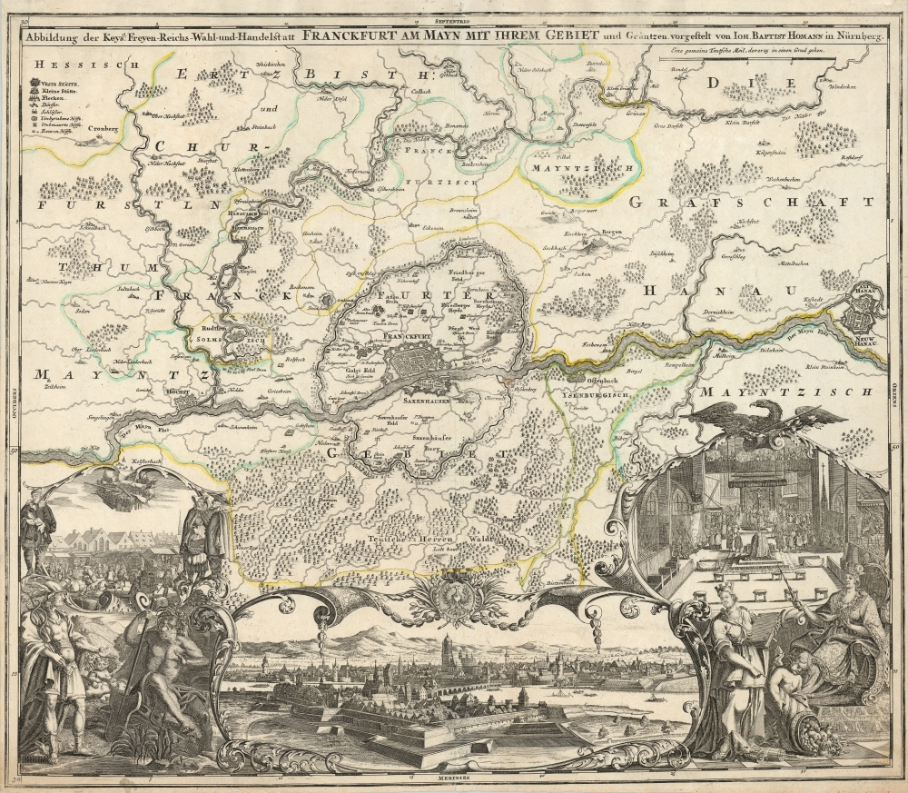
Abbildung der Keysrl. Freyen Reichs, Wahl und Handelstatt Franckfurt am Mayn mit ihrem Gebiet und Gräntzen vorgestelt von Ioh. Baptist Homann in Nürnberg.
1716 (undated) 19.25 x 22.5 in (48.895 x 57.15 cm) 1 : 36000
1716 (undated) 19.25 x 22.5 in (48.895 x 57.15 cm) 1 : 36000
Description
This is a beautifully engraved Johann Baptist Homann map of Frankfurt and its surrounds, including a magnificent panorama of the city, flanked with allegorical cartouches. Frankfurt am Main (that is, Frankfurt on the river Main, so called to distinguish from Frankfurt an der river Oder) is shown on the north bank of its namesake river. As a riverine city near the physical center of western Europe, Frankfurt was a key city not solely for the Holy Roman Empire, but for Europe overall.
A Closer Look
The vignette to the right - surmounted with an Imperial Eagle, shows a coronation underway in the St. Bartholomäuskirche. The foreground of this scene shows an enthroned figure, representing the Empire. A standing 'Italia Turrita' representing historical Rome carrying a great tome points at a putto dumping a cornucopia representing the fruitful Empire overall, and the great city in particular. The cartouche vignette to the left illustrates the Frankfurt messe: the fair which brought merchants of every trade from all over Europe twice a year. Merchants are shown hauling goods, displaying them in stalls, and hustling in a vigorous scene. In the background, the heart of the messe - the city hall or Römer can be seen. The scene is framed with figures representing merchants, as well as allegorical figures: caduceus - bearing Mercury (patron of communication and trade) is a natural overseer for the fair; and the bearded Moenus presides over the river he represents. A putto bearing grapes reflects either the importance of the city's wine trade, or the importance of wine overall to every trade fair. Between the allegorical vignettes is a north-facing view of the city, with the fortifications of Sachsenhausen in the foreground with the Taunus mountains in the background.Publication History and Census
This map was engraved as early as 1705 for inclusion in Homann's atlases. A later plate, entirely re-engraved and bearing the Imperial Privilege, replaced this one c. 1724. This first plate example corresponds to examples seen in 1716 editions of Homann's Atlas Novus Terrarum Orbis Imperia Regna.Cartographer
Johann Baptist Homann (March 20, 1664 - July 1, 1724) was the most prominent and prolific map publisher of the 18th century. Homann was born in Oberkammlach, a small town near Kammlach, Bavaria, Germany. As a young man, Homann studied in a Jesuit school and nursed ambitions of becoming a Dominican priest. Nonetheless, he converted to Protestantism in 1687, when he was 23. It is not clear where he mastered engraving, but we believe it may have been in Amsterdam. Homann's earliest work we have identified is about 1689, and already exhibits a high degree of mastery. Around 1691, Homann moved to Nuremberg and registered as a notary. By this time, he was already making maps, and very good ones at that. He produced a map of the environs of Nürnberg in 1691/92, which suggests he was already a master engraver. Around 1693, Homann briefly relocated to Vienna, where he lived and studied printing and copper plate engraving until 1695. Until 1702, he worked in Nuremberg in the map trade under Jacob von Sandrart (1630 - 1708) and then David Funck (1642 - 1709). Afterward, he returned to Nuremberg, where, in 1702, he founded the commercial publishing firm that would bear his name. In the next five years, Homann produced hundreds of maps and developed a distinctive style characterized by heavy, detailed engraving, elaborate allegorical cartouche work, and vivid hand color. Due to the lower cost of printing in Germany, the Homann firm could undercut the dominant French and Dutch publishing houses while matching their diversity and quality. Despite copious output, Homann did not release his first major atlas until the 33-map Neuer Atlas of 1707, followed by a 60-map edition of 1710. By 1715, Homann's rising star caught the attention of the Holy Roman Emperor Charles VI, who appointed him Imperial Cartographer. In the same year, he was also appointed a member of the Royal Academy of Sciences in Berlin. Homann's prestigious title came with several significant advantages, including access to the most up-to-date cartographic information as well as the 'Privilege'. The Privilege was a type of early copyright offered to very few by the Holy Roman Emperor. Though less sophisticated than modern copyright legislation, the Privilege offered limited protection for several years. Most all J. B. Homann maps printed between 1715 and 1730 bear the inscription 'Cum Priviligio' or some variation. Following Homann's death in 1724, the firm's map plates and management passed to his son, Johann Christoph Homann (1703 - 1730). J. C. Homann, perhaps realizing that he would not long survive his father, stipulated in his will that the company would be inherited by his two head managers, Johann Georg Ebersberger (1695 - 1760) and Johann Michael Franz (1700 - 1761), and that it would publish only under the name 'Homann Heirs'. This designation, in various forms (Homannsche Heirs, Heritiers de Homann, Lat Homannianos Herod, Homannschen Erben, etc.) appears on maps from about 1731 onwards. The firm continued to publish maps in ever-diminishing quantities until the death of its last owner, Christoph Franz Fembo (1781 - 1848). More by this mapmaker...
Source
Homann, J. B., Neuer Atlas bestehend in einig curieusen Astronomischen Kuppren und vielen auserlesenen accuratensten Land-Charten über die Gantze Welt, (Nuremberg: Homann), 1716.
Homann's Neuer Atlas bestehend in einig curieusen Astronomischen Kuppren und vielen auserlesenen accuratensten Land-Charten über die Gantze Welt was first publihsed in 1707 with 33 maps. A second edition followed in 1710 with 60 maps. Subsequent editions followed until about 1730. The title page notes proudly that the atlas features measurements based on the 'Copernican principle of the moving sky', a truly state-of-the-art innovation for the period. Regardless of editions, collations of the atlas are inconsistent, with some examples having less, while others have more maps - a consequence of the fact that the map sheets were delivered loose, to be bound at the buyer's discretion, and so some buyers chose to omit maps they did not consider relevant, or add others they did. Between editions, the constituent maps, particularly of European regions, were regularly updated to reflect the most recent political events. The atlas continued to be published by Homann's son, J. C. Homann (1703 - 1730), and then by Homann Heirs. Most examples also feature a fine allegorical frontispiece with the title Atlas Novus Terrarum Orbis Imperia, regna et Status, which was used for multiple Homann atlases, including the Neuer Atlas and the Atlas Minor.
Condition
Very good. Reinforced bottom margin, traces of original outline color.
References
OCLC 868187175 Rumsey 12499.124.