This item has been sold, but you can get on the Waitlist to be notified if another example becomes available, or purchase a digital scan.
1874 Merrill Map of the Battle of Franklin during the American Civil War
Franklin-merrill-1874$175.00

Title
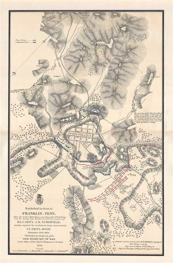
Battlefield in front of Franklin, Tenn. where the United States Forces, consisting of the 4th and 23rd Corp and the Cavalry Corps M.D.M., all under the command of Maj. Gen'l J.M. Schofield, severely repulsed the Confederate Army, commanded by Lt. Gen'l Hood November 30th 1864.
1874 (dated) 28.5 x 19 in (72.39 x 48.26 cm) 1 : 10560
1874 (dated) 28.5 x 19 in (72.39 x 48.26 cm) 1 : 10560
Description
This is a separate issue 1874 William Emery Merrill map of the Battle of Franklinduring the American Civil War. Founded in a bend of the Harpeth River, Franklin, Tennessee and its environs are depicted here in incredible detail. Stretching from Dr. Ewing's homestead on the left to S. C. Owen's homestead on the right and from Mrs. Eweler's house near the top to the Kirkpatrick estate near the bottom, numerous homesteads, houses, and settlements are labeled with their owner's name throughout and, within Franklin itself, the individual streets are illustrated and labeled. Even more detail is added through the illustration of roads and railroads, and detailed topography is included and shown by hachure. Union and Confederate forces are illustrated in their battle lines, predominantly to the southeast of Franklin, with the Union forces colored blue and Confederate forces shaded in red.
The Battle of Franklin
The Battle of Franklin, which took place on November 30, 1864, was one of the worst disasters of the war for the Confederate States Army. Led by Lieutenant General John Bell Hood, Confederate forces attacked a fortified Union force and was unable to dislodge the Union soldiers from the position. Although the Confederates exploited a gap in Union fortifications at the beginning of the battle, they were unable to fully take advantage of the break through. The battle ended in a Union counterattack and, essentially, a stalemate, as the Confederates ended the day almost exactly where they had started it. Confederate casualties at least doubled, if not tripled, those suffered by the Union army, and, under the cover of darkness, Union forces abandoned Franklin and continued their very organized retreat to Nashville, where they reinforced an already strong Union defensive line.
This map was compiled under the direction of William Emery Merrill from surveys made by Major James R. Willett, and Major T.J.L. Remington and was published by orde4r of the Secretary of War in the Office of the Chief of Engineers of the U.S. Army. While represented in institutional collections, this map is rarely seen on the market.
Cartographer
William Emery Merrill (October 11, 1837 - December 14, 1891) was an American engineer and soldier. Born at Fort Howard, Wisconsin, Merrill was the son of Captain Moses Merrill (1803 - 1847), a distinguished officer who was killed leading the 5th U.S. Infantry at the 1847 Battle of Molino del Ray, during the Mexican-American War (1846 - 1848). Then President Franklin Pierce (1804 - 1869), as a tribute to the elder Merrill, nominated William Emery as a legacy candidate to United States Military Academy at West Point. Merrill, excelled at engineering, graduated first in the West Point class of 1859. He subsequently worked as an assistant professor of engineering at the Academy from September 1860 until July 1861. At the outbreak of the American Civil War (1861 - 1865), Merrill was sent to construct fortifications with the Department of the Ohio. There, during the September 1861 Battle of Cheat Summit Fort, Merril was captured and sent to Richmond, VA, where he remained until February 1862, when he was paroled. He was then sent to Fort Monroe, where he was commissioned as an assistant engineer to the Union Army of the Potomac, in which capacity he served during the Peninsular Campaign and Northern Virginia Campaign. In 1863, Union Major General William S. Rosecrans, 'Olde Rosy', promoted Merrill to 'Engineer Officer in chart of the Topographical Department.' His work mapping Tennessee and Northern Georgia proved instrumental and revolutionary, leading to Union victories in the region. Later in the war, from July 1864 until September 1865, Merrill commanded a regiment of veteran volunteer engineers in the service of the Armies of Kentucky and the Cumberland, where he participated in most major engagements. During his service in the Civil War, Merrill competed a number of important maps for use by officers in the field. After the war, from 1867 until 1870, Merrill took the position of Chief Engineer on the staff of General William T. Sherman (1820 - 1891). When he left Sherman's staff in 1870, he took on various government contracts for improvements to the Ohio, Allegheny, Monongahela and Muskingum Rivers. In this capacity he wrote two engineering manuals on bridges and dam building. Merrill died suddenly from a heart attack while on this assignment on a train in Ohio. More by this mapmaker...
Condition
Very good. Even overall toning. Closed margin tears professionally repaired on verso. Blank on verso.
References
LOC G3964.F7S5 1874 .M41. Stephenson, R. W., Civil War Maps; an Annotated List of Maps and Atlases in Map Collections of the Library of Congress, 423. OCLC 50540153.