1943 Chapin Map of Northern Hemisphere Great Circle Aviation Routes
FreedomAir-chapin-1943$500.00

Title
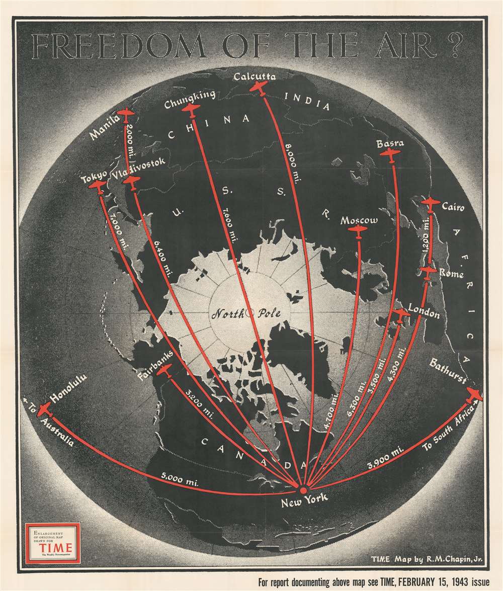
Freedom of the Air?
1943 (dated) 40.5 x 34.5 in (102.87 x 87.63 cm)
1943 (dated) 40.5 x 34.5 in (102.87 x 87.63 cm)
Description
This is a 1943 Robert M. Chapin, Jr. map of the Northern Hemisphere and its great circle aviation routes. Red lines highlight eleven great circle routes from New York to points across the hemisphere, including London, Rome, Tokyo, Moscow, Calcutta, Fairbanks, and Honolulu. Each route's distance from New York appears in miles and silhouettes of the iconic DC-3 / C-47 mark each city.
What are Great Circle Routes?
Great circle routes are the shortest distance between two points on the surface of a sphere. On this map, Chapin illustrates how these routes all 'go over the top of the world' and may include flying over several different countries depending on the destination.Why Talk About This Now? Aren't We Fighting a World War?
Considering when this map was published, in mid-February 1943, this discussion of air routes comes from two different perspectives The first is directly related to the war effort, when the United States was undertaking the logistical marvel of sending supplies around the world by air. Never before had worldwide air routes been pioneered as quickly as air supply routes during 1942 and into 1943. Both military and civilian transport aircraft flew these routes and provided essential supplies and personnel to military bases worldwide. The second reason was foresight. The U.S. spent billions of dollars building air bases and the supporting infrastructure (hangers, weather reporting stations, radio stations, etc.) worldwide. Six months after the war ended (and everyone knew the war would end eventually) those bases would all revert to the nation where they had been built. Pilots, and others involved in aviation, began pushing global aviation standards in 1943.Publication History and Census
This map is a separately issued enlargement of a map drawn by Robert M. Chapin, Jr. for publication in the February 15, 1943 issue of TIME. An example is cataloged in OCLC and is part of the institutional collection at Franklin and Marshall College.Cartographer
Robert M. Chapin Jr. (fl. 1933 - 1970) was a prominent architect, cartographer and illustrator active during World War II and the Cold War. Chapin graduated from the University of Pennsylvania in 1933 with a degree in architecture. Since this was the height of the Great Depression, and architects in low demand, he instead took work as a staff cartographer at Newsweek. Catching the attention of Manfred Gottfried of Time, Chapin was offered an accepted a position at the head of Time's cartography department. He remained with Time for some 33 years, from 1937 to 1970, often drawn 2 - 3 new thematic maps weekly. With an architect's gift visualizing information, Chapin became a skilled informational cartographer, heading the cartography department at Time Magazine. Chapin, like Fortune Magazine chief cartographer, Richard Edes Harrison, Chapin was at the forefront of infographic propaganda cartography, a genre that matured during the World War II Era and remains popular today. Working for Time Magazine, Chapin developed a signature style for his long run of 'War Maps.' Chapin was known for his maverick airbrush technique which lead to strong color splashes and intense shading. He also incorporated celluloid stencils to illustrate bomb explosions, flags, sinking ships, and more - generating a instantly recognizable standardized style. Chapin's Time war maps were further distinctive for their use of strong bold reds as a universal symbol of hostility. Chapin graduated from the University of Pennsylvania in 1933 with a degree in architecture. Since this was the height of the Great Depression, an d architects in low demand, he instead took work as a staff cartographer at Newsweek. Catching the attention of Manfred Gottfried of Time, Chapin was offered an accepted a position at the head of Time's cartography department. He remained with Time for some 33 years, from 1937 to 1970, often drawn 2 - 3 new thematic maps weekly. Chapin live in Sharon Connecticut. More by this mapmaker...
Condition
Very good. Verso repairs to fold separations an at fold intersections. Exhibits some wear and toning along original fold lines. Closed margin tear professionally repaired on verso. Blank on verso.
References
OCLC 947055114.