This item has been sold, but you can get on the Waitlist to be notified if another example becomes available, or purchase a digital scan.
1846 Kemble Map of Early French Missions around Lake Superior and Lake Michigan
FrenchMissions-kemble-1846$50.00

Title
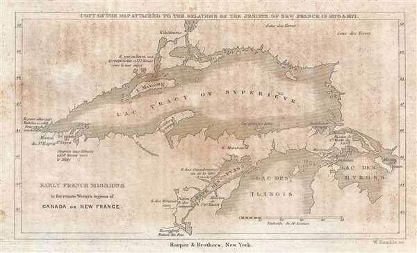
Early French Missions in the remote Western regions of Canada or New France. Copy of the Map Attached to the Relations of the Jesuits in New France in 1670 and 1671.
1846 (undated) 4.25 x 7.25 in (10.795 x 18.415 cm) 1 : 4120000
1846 (undated) 4.25 x 7.25 in (10.795 x 18.415 cm) 1 : 4120000
Description
This is an 1846 William Kemble map of the region surrounding Lake Superior and the northern portion of Lake Michigan. The map depicts the region from modern-day Minnesota and Wisconsin to Michigan, Lake Huron, and Canada and from Canada and Minnesota to Wisconsin and Michigan. Several locations around the region are labeled marking the locations of Jesuit missions. One of the missions is located at the extreme western tip of Lake Superior, while the others are concentrated around Lake Michigan and on Michigan's Upper Peninsula, including the mission at Sault Ste. Marie, Michigan. This mission was founded in 1668, making Sault Ste. Marie the third-oldest European city in the United States west of the Appalachian Mountains and the oldest permanent settlement in Michigan state. Several Native American nations are noted, along with routes and distances from certain locations to others. Islands and bays in the lakes are also labeled.
This map was created by William Kemble for publication in John W. Monette's History of the Discovery and Settlement of the Valley of the Mississippi, by the Three Great European Powers, Spain, France, and Great Britain, and the Subsequent Occupation, Settlement, and Extension of Civil Government by the United States Until the Year 1846, published by Harper and Brothers in 1846.
This map was created by William Kemble for publication in John W. Monette's History of the Discovery and Settlement of the Valley of the Mississippi, by the Three Great European Powers, Spain, France, and Great Britain, and the Subsequent Occupation, Settlement, and Extension of Civil Government by the United States Until the Year 1846, published by Harper and Brothers in 1846.
CartographerS
William Kemble (1813 - c. 1870) was a New York City based merchant and engraver active in the middle part of the 19th century. Kemble immigrated with his wife Sarah from England to the United States on December 31, 1843 on board the ship Passmoz. He settled in New York where he established himself as an artist, merchant, publisher, inventor, and engraver. Kemble was on the 1839 management committee of the American Art Union, a now defunct organization focused on promoting subscription based sales of American art. He was also a founding member of the Century Club, an arts club that included John G. Chapman, a well-known painter, among others. Kemble is buried in Cyprus Hills Cemetery. More by this mapmaker...
Harper and Brothers (1817 – Present) is New York based American printing publishing firm founded in 1817 by James Harper and his brother John Harper as J. and J. Harper (1817-1833). Their younger brothers Joseph Wesley Harper and Fletcher Harper joined the company around 1926 prompting the 1833 imprint change to Harper and Brothers (1833 – 1962). The firm published countless books, magazines, prints, maps, and more. They began publishing a monthly magazine, Harper's Monthly in 1850. The success of Harper's Monthly led to the introduction of a popular weekly illustrated journal, Harper's Weekly published from 1857 - 1916. They later introduced Harper's Bazar (1867) and Harper's Young People (1879). From about 1899 the business went through a series of permutations selling off some assets and developing others. The company merged with Row, Peters and Company inn 1962, rebranding itself as Harper and Row (1962 – 1990), which was acquired by Marshall Pickering in 1988. It was acquired by Rupert Mordoch (News Corp) and merged with William Collins and Sons in 1990 to form HaprerCollins (1990 – Present), the imprint under which it still publishes. Their original offices were at 331 Franklin Street, roughly below today's Manhattan Bridge. Today they have many offices and are one of the world's largest publishing companies and one of the 'Big Five' English-language publishers. Learn More...
Source
Monette, J. History of the Discovery and Settlement of the Valley of the Mississippi, by the Three Great European Powers, Spain, France, and Great Britain, and the Subsequent Occupation, Settlement, and Extension of Civil Government by the United States Until the Year 1846 (New York: Harper and Brothers) 1846.
Condition
Very good. Light foxing. Blank on verso. Text in French.