1879 Corps of Engineers Map of the Civil War Battle of Funkstown, Maryland
Funkstown-engineers-1879$300.00


Title
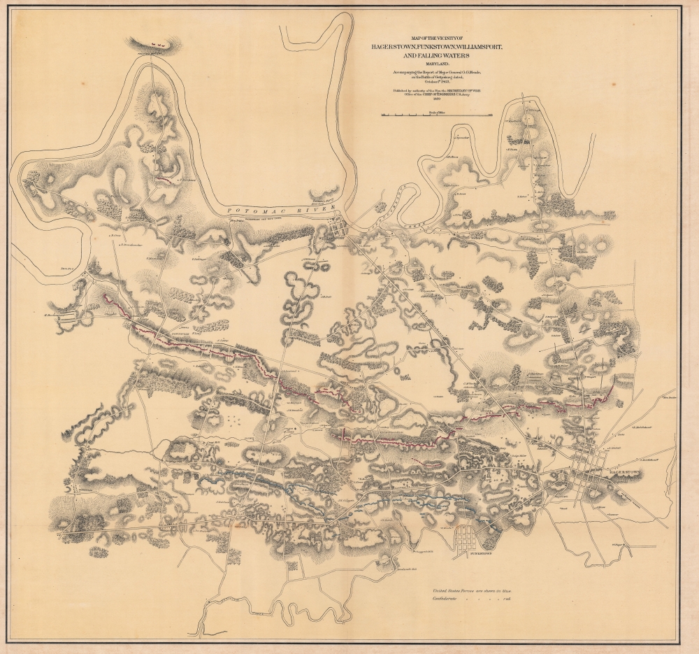
Map of the Vicinity of Hagerstown, Funkstown, Williamsport, and Falling Waters Maryland.
1879 (dated) 37 x 35 in (93.98 x 88.9 cm) 1 : 21500
1879 (dated) 37 x 35 in (93.98 x 88.9 cm) 1 : 21500
Description
This is a separate issue 1879 U.S. Army Corps of Engineers map of the Battle of Funkstown (Maryland) during the Gettysburg Campaign of the American Civil War (1861 - 1865). The Battle of Funkstown occurred a week after the Battle of Gettysburg as the Union Army commanded by Major General George Meade pursued General Robert E. Lee and the retreating Confederate Army.
A Closer Look
The map depicts the region from Bakersville and the Potomac River to Hagerstown and from Conococheague Creek to Funkstown and Antietam Creek. Numerous villages and individual homesteads are illustrated, along with mills, a nursery, and the College of St. James. Roads crisscross the terrain and the towns of Williamsport, Funkstown, and Hagerstown are each illustrated with city streets. Union (blue) and Confederate (red) positions and movements are illustrated.The Battle of Funkstown
The Battle of Funkstown, also known as the Second Battle of Funkstown, was fought near Funkstown, Maryland, on July 10, 1863. The Union Army was pursuing the retreating Confederate Army of Northern Virginia when Union forces attacked the Confederate rear guard. This skirmish occurred because the Confederate position at Funkstown threatened any Union advance on Lee's main force at Williamsport. The battle resulted in a combined 479 casualties and Confederate Major General J.E.B. Stuart's cavalry managed to hold against the Union advance, forcing the Union Army to withdraw by early evening. By withstanding the Union advance, Stuart secured the retreat of Lee's army for at least another day.Publication History and Census
This map was produced by the Army Corps of Engineers and published in 1879. We note five examples cataloged in OCLC which are part of the collections at Harvard University, the Cincinnati History Library, the Abraham Lincoln Presidential Library, the University of California Berkeley, and the University of California Los Angeles.Condition
Good. Wear and toning along original fold lines. Slight loss at fold intersection. Closed margin tears professionally repaired on verso. Close top margin.
References
LOC G3840 1879 .U5. Stephenson, R. W., Civil War Maps; an Annotated List of Maps and Atlases in Map Collections of the Library of Congress, 245. OCLC 19261198, 905553232.