This item has been sold, but you can get on the Waitlist to be notified if another example becomes available, or purchase a digital scan.
1710 Dampier / Moll Map of the Galapagos
Galapagos-dampier-1710$250.00

Title
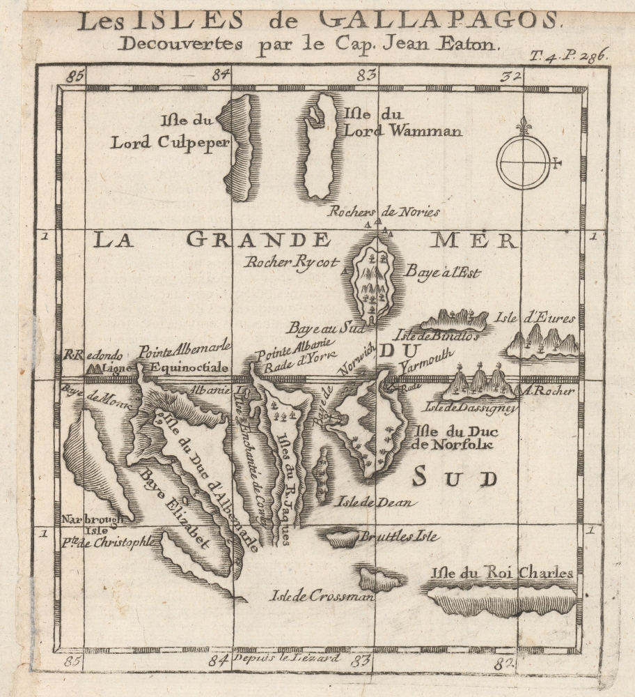
Les Isles de Gallapagos, Decouvertes par le Cap. Jean Eaton.
1710 (undated) 5.5 x 6 in (13.97 x 15.24 cm) 1 : 3500000
1710 (undated) 5.5 x 6 in (13.97 x 15.24 cm) 1 : 3500000
Description
This is the first published map of the Galapagos Islands, originally produced by William Ambrosia Cowley and published c. 1710 in Nouveau Voyage Autour du Monde, the French translation of William Dampier's A New Voyage Round the World, a work that influenced Gulliver's Travels, Robinson Crusoe, and Charles Darwin.
A Closer Look
The Galapagos Islands are displayed in their approximate locations, with their English names which are generally not used today (aside from English royalty and nobility, Cowley named some islands after officials in Jamaica who he hoped would provide financial support to future endeavors). The geography is crude; for instance, Culpeper Island (now Darwin Island) is much further to the northwest than displayed here. Most of the other islands are misshapen. Nevertheless, as the first published map to focus specifically on the islands, this map was important for introducing the islands to the public consciousness of Europe, and remained the standard map of the islands for a century, until James Colnett's 1793 chart for the Royal Navy.The Galápagos Islands
In the 1700s, the Galápagos Islands, an archipelago situated roughly 1,000 kilometers west of the South American continent, remained largely untouched by human civilization. These volcanic islands, which are today famed for Charles Darwin's visit and their unique biodiversity, were occasionally frequented by pirates and buccaneers who used them as hideouts and resupply points. However, it was not until the late 18th and early 19th centuries that whalers and fur seal hunters began to make regular stops. Nevertheless, throughout the 1700s, the Galápagos largely maintained their pristine state, teeming with species that had evolved in isolation and offering Darwin an unparalleled glimpse into the wonders of natural selection.Publication History and Census
This map appeared in the French translation of William Dampier's A New Voyage Round the World, originally published in English in 1697. Though as captain of the ship, John Eaton is credited with the discovery of the islands, the original manuscript map was drawn by one of his officers, William Ambrosia Cowley, and then engraved by Herman Moll (uncredited in the translation here). It was also published in William Hacke's Collection of Original Voyages in 1699 and in A collection of voyages, a 1729 work combining Dampier's account with those of other contemporary English navigators and adventurers. The French edition of the map is not independently cataloged with any institution while the English original is cataloged by the British Library. Both the French and English editions of Dampier's full work are well-represented in institutional collections.CartographerS
Herman Moll (1654 - 1732) was an important 18th century map publisher and engraver based in London and Holland. Moll's origins are disputed with some suggesting he was born in the Netherlands and others Germany - the Moll name was common in both countries during this period. Most likely Moll was a German from Bremen, as his will, friends, and contemporaries suggest. What is known for certain is that he moved to London in 1678, possibly fleeing the Scanian War, where he worked as an engraver for Moses Pitt and other London map publishers. Around the turn of the century, Moll set up his own shop where he produced a large corpus of work known for its high quality and decorative flair. As a new émigré to England, Moll made himself more English than the English, and through his cartography proved a fierce advocate for his adopted nation. Most of Moll's early maps were issued as loose sheets that would be bound to order, however, he did publish several important atlases late in his career. Moll is said to have made the bold claim that without a doubt "California is an Island" and that he "had in [his] office mariners who have sailed round it." While California may not be an island (yet), it is true that moll had talent for attracting interesting friends and acquaintances. He frequented London's first stock exchange, Jonathan's Coffeehouse at Number 20 Exchange Alley, Cornhill. At the time Jonathan's was known as "a place of very considerable concourse for Merchants, sea faring Men and other traders" (Erleigh, The Viscount, The South Sea Bubble, Manchester: Peter Davies, Ltd., 1933, 21). Eventually this activity attracted the interest of stock brokers, who inspired by sailor's tales, sponsored the ill-fated South Sea Company, the world's first stock bubble. Moll's close circle, mostly from the Coffee House, included scientist Robert Hooke, the writers Daniel Defoe (Robinson Crusoe) and Jonathan Swift (Gulliver's Travels), the pirates William Dampier, William Hacke and Woodes Rogers, and the archeologist William Stukeley. Herman Moll's work was highly regarded for its decorative beauty and was pirated, most notably by the Irish publisher George Grierson, both in his lifetime and after his 1732 death at St. Clement Danes, London. More by this mapmaker...
Server Error
404
Page Not Found
This page either doesn't exist, or it moved somewhere else.
That's what you can do
William Dampier (1651 - 1715) was an English navigator, explorer, naturalist, and privateer (pirate) who was the first person to circumnavigate the globe three times, being the first Englishman to leave a written account of Australia. Born in Somerset, Dampier was educated at King's School, Bruton, before traveling on merchant vessels bound for Newfoundland and Java and then joining the Royal Navy. He tried his hand at various businesses in the New World, but in 1679 joined up with English buccaneers raiding Spanish interests in the Americas and East Indies. In 1691, Dampier returned to England short on money and prospects; he was also apparently court-martialed by the Royal Navy for imprisoning one of his lieutenants in Brazil. But he was able to publish his A New Voyage Round the World in 1697, a work that strongly influenced Jonathan Swift's Gulliver's Travels and Damiel Defoe's Robinson Crusoe. Dampier was commissioned as a commander in the Royal Navy during the War of the Spanish Succession and tasked with raiding Spain's Manila Galleons. He continued to raid Spanish ships with limited success until 1711 and died in 1715 in London. Learn More...
Source
Dampier, G., Nouveau Voyage autour du Monde (Rouen: Eustache Herauit) c. 1715.
Condition
Good. Remargined on top and left, as is typical (map was trimmed closely at top and left to fit into book).
References
OCLC 557482457 (English edition).