This item has been sold, but you can get on the Waitlist to be notified if another example becomes available, or purchase a digital scan.
1752 Leach / Kitchin Map of the Middle Gambia River, West Africa
GambiaLeach-kitchin-1752$137.50

Title
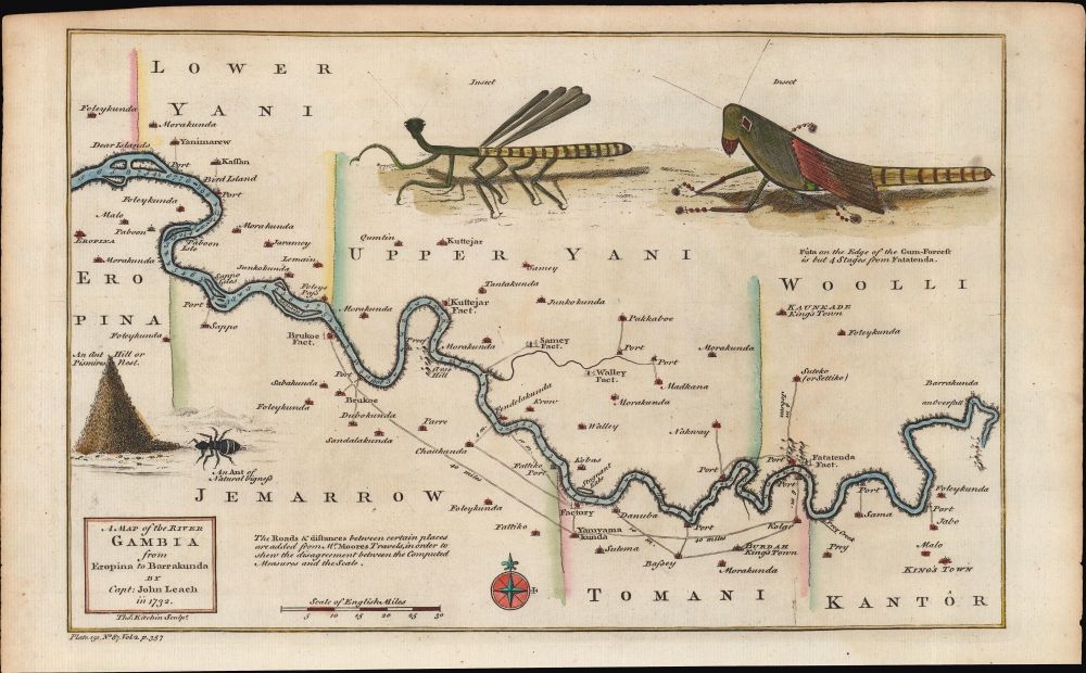
A Map of the River Gambia from Eropina to Barrakunda.
1752 (dated) 8.5 x 13 in (21.59 x 33.02 cm) 1 : 900000
1752 (dated) 8.5 x 13 in (21.59 x 33.02 cm) 1 : 900000
Description
A fine example of Thomas Kitchin's 1752 map of the middle portion of the Gambia River, based on the description of John Leach, an agent of the Royal African Company. It highlights reconnaissance from Leach's travels, which were recounted in several works in the years afterwards, eliciting popular interest among the British public.
Trading posts ('factories'), ports, and other facilities utilized by British traders and their agents line the river. Many indigenous settlements are indicated, as are the approximate borders between local kingdoms or chieftainships. Due to his extended foray in the region, Leach was well informed about local political constellations, and labels a few settlements as 'king's town'.
On the water, soundings are recorded all along the river. Roads between settlements are traced, with distances noted. This information was derived from Francis Moore's Travels into the inland parts of Africa. Illustrations of insects surround the map, including a large ant hill at left.
This edition of the map with the present notation ('Pl. 150, No. 87, Vol. 2, p. 357') is held by the New York Public Library, which dates it to 1732, too early given that Kitchin was born in 1718. Research by Barbara McCorkle suggests that this edition of the map appeared in Thomas Salmon's The universal traveller: or, a compleat description of the several foreign nations of the world, published in 1752 - 1753. Regardless of printing, this map appeared in close proximity to 'A Map of the River Gambia from its Mouth to Eropina' (also sold by us), which covers the lower portion of the river to the west of the area seen here.
A Closer Look
Coverage extends along the Gambia River from Eropina and the 'Dear Islands' (Pasri and Deer Island), roughly halfway into the territory of the contemporary nation-state of The Gambia, eastwards to the area on the present-day border between The Gambia and Senegal. The travels of John Leach, an agent of the Royal African Company, inform the map. Leach and Thomas Harrison explored the area in 1732 in search of trading opportunities. The Royal African Company was a chartered monopoly created to manage English / British trade along the west coast of Africa. It was supplanted in the early 18th century, leading to a free-for-all among private traders, contributing to an increase in the scale and brutality of the slave trade.Trading posts ('factories'), ports, and other facilities utilized by British traders and their agents line the river. Many indigenous settlements are indicated, as are the approximate borders between local kingdoms or chieftainships. Due to his extended foray in the region, Leach was well informed about local political constellations, and labels a few settlements as 'king's town'.
On the water, soundings are recorded all along the river. Roads between settlements are traced, with distances noted. This information was derived from Francis Moore's Travels into the inland parts of Africa. Illustrations of insects surround the map, including a large ant hill at left.
Publication History and Census
This map was engraved by Thomas Kitchin based on descriptions by John Leach. Its provenance is somewhat unclear; maps based on Leach's travels first appeared in Francis Moore's Travels into the inland parts of Africa (1738), but they differ widely from Kitchin's work. (Moore's work is referred to above the scale, confirming that this map was produced afterwards.) The present map was included in A New General Collection of Voyages and Travels, published between 1745 and 1747, but its notation in that work is entirely different. It was reproduced in French by Nicholas Bellin for l'Abbé Prevost’s Histoire generale des voyages.This edition of the map with the present notation ('Pl. 150, No. 87, Vol. 2, p. 357') is held by the New York Public Library, which dates it to 1732, too early given that Kitchin was born in 1718. Research by Barbara McCorkle suggests that this edition of the map appeared in Thomas Salmon's The universal traveller: or, a compleat description of the several foreign nations of the world, published in 1752 - 1753. Regardless of printing, this map appeared in close proximity to 'A Map of the River Gambia from its Mouth to Eropina' (also sold by us), which covers the lower portion of the river to the west of the area seen here.
Cartographer
Thomas Kitchin (August 4, 1718 – June 23, 1784) was a London based engraver, cartographer, and publisher. He was born in London to a hat-dyer of the same name. At 14, Kitchin apprenticed under Emanuel Bowen, under whom he mastered the art of engraving. He married Bowen daughter, Sarah Bowen, and later inherited much of his preceptor's prosperous business. Their son, Thomas Bowen Kitchin, also an engraver joined the family business, which thereafter published in Thomas Kitchin and Son. From 1858 or so Kitchin was the engraver to the Duke of York, and from about 1773 acquired the title, 'Royal Hydrographer to King George III.' He is responsible for numerous maps published in the The Star, Gentleman's Magazine, and London Magazine, as well as partnering with, at various times, with Thomas Jefferys, Emmanuel Bowen, Thomas Hinton, Issac Tayor, Andrew Dury, John Rocque, Louis de la Rochette, and Alexander Hogg, among others. Kitchin passed his business on to his son, Thomas Bowen Kitchin, who continued to republish many of his maps well after his death. Kitchin's apprentices included George Rollos, Bryant Lodge, Thomas Bowen Kitchin, Samuel Turner Sparrow, John Page, and Francis Vivares. More by this mapmaker...
Condition
Very good.
References
Barbara Backus McCorkle, 'A Carto-Bibliography of the Maps in Eighteenth-Century British and American Geography Books,' Digital Publishing Services, University of Kansas Library (2009). OCLC 316386859 (variant printing).