
1631 / 1635 Blaeu Map of Gascony (Bordeaux, Medoc, Béarn)

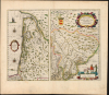
Carte du Bourdelois, du pais de Medoc, et de la prevosté de Born./ Principatus Benearnia. La Principaute de Bearn.
Mapping Gascony.
- Digital Map Information
- Suitable for large format printing
- Full resolution TIFF file
- ICC color profile embedded
- Delivered instantly via download link
Mapping Gascony.
This is Willem Blaeu's 1631 map of the Basque country of Gascony in southwestern France, including the wine country of Bordeaux and Medoc. It is printed along with a map focusing on the Principality of Béarn, also part of the Duchy of Gascony. The region is now the western part of Nouvelle-Aquitaine, mainly the départements of Gironde, Landes, and Pyrénées-Atlantique.A Closer Look
The sheet contains two maps, both oriented to the north. The left-hand map reaches from the Basque region of Spain to the mouth of the Garonne River, and from Hondarribia in the west to as far east as Mont-de-Marsan. It shows cities and towns, with particular emphasis on the walled cities of Bayonne and Bordeaux. Dax and Lesparre-Médoc are among the larger cities noted. The coastline - predominantly France's Côte d'Argent - is shown in detail. A lighthouse is noted in the mouth of the Garonne. The Baye de Arcachon is accurately portrayed. The Lac d'Hourtin-Carcans and Lac de Lacanau appear to be conflated as a single lake: it contains a French text describing the lake as five leagues long and one league wide; it is shown reaching from St. Helena de l'Estang in the north to Le Porge in the south. Along the frontier with Spain, another note in French describes Mount La Rhune (Rheune montaigne) as having, at its peak, a chapel from which one can see the kingdoms of France, Spain, Navarre, and Aragon. The mountain and its chapel are pictured.The right-hand map, presented at a larger scale, focuses specifically on the Principality of Béarn. It highlights the towns along the tributaries of the Gave d'Oloron. Sauveterre-de-Béarn, Navarrenx, Oloron-Sainte-Marie, Orthez, Pau, and Monein are emphasized, but many other towns are marked as well. To the south, the Pyrenees are illustrated pictorially.
New Maps of a New Frontier
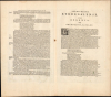
Both Blaeu and Hondius share a clear precursor for their maps of Bordeaux and the Medoc: Jean le Clerc's La Carte du Bourdelois, du Pays de Medoc, et de la Prevoste de Born, produced in and around 1619 for inclusion in his Theatre Geographique du Royaume de France. Le Clerc's atlas represented the best compilation of French maps from a French source available at the time that both Blaeu and Hondius were becoming fierce competitors, and it is reasonable that both might have utilized it as a source. It is an easy assumption that Le Clerc also supplied the source for the map of Béarn. However, we have been unable to identify a comparable printed map from any source that could credibly have provided a source for the Béarn maps of either Blaeu or Hondius. It may be that either cartographer received a manuscript from a French source, and that such new matter would have been produced contemporaneously. Before the reign of Henry IV of France (1553 - 1610), Béarn had been an independent principality; with his accession, it became part of the lands of the King of France. His son, Louis XIII, would in the 1620s employ force to subdue protestant nobility in the region; both the military and administrative efforts to absorb this new territory would have occasioned a new map.In addition to the verso text printed to the map itself, this includes the following leaf from the atlas containing the full description of the Principality of Béarn.
Publication History and Census
This map first appeared in Blaeu's Atlas Novus in 1631, continuing to appear in that work in this form until about 1662, at which point the plate was cut to allow the two maps to appear separately in Joan Blaeu's Atlas Maior. For the first impressions of the map, the coat of arms of Béarn was left blank; beginning in 1634, the arms were completed. The present example is of the second state, with the arms complete; the text corresponds to the Latin Atlas Novus edition of 1635. The map is well represented in institutional collections and appears on the market from time to time, although original color examples of this quality are increasingly difficult to find.Cartographers
Willem Janszoon Blaeu (1571 - October 18, 1638), also known as Guillaume Blaeu and Guiljelmus Janssonius Caesius, was a Dutch cartographer, globemaker, and astronomer active in Amsterdam during the late 16th and early 17th centuries. Blaeu was born 'Willem Janszoon' in Alkmaar, North Holland to a prosperous herring packing and trading family of Dutch Reformist faith. As a young man, he was sent to Amsterdam to apprentice in the family business, but he found the herring trade dull and instead worked for his cousin 'Hooft' as a carpenter and clerk. In 1595, he traveled to the small Swedish island of Hven to study astronomy under the Danish Enlightenment polymath Tycho Brahe. For six months he studied astronomy, cartography, instrument making, globe making, and geodesy. He returned to Alkmaar in 1596 to marry and for the birth of his first son, Johannes (Joan) Blaeu (1596 – 1673). Shortly thereafter, in 1598 or 1599, he relocated his family to Amsterdam where he founded the a firm as globe and instrument makers. Many of his earliest imprints, from roughly form 1599 - 1633, bear the imprint 'Guiljelmus Janssonius Caesius' or simply 'G: Jansonius'. In 1613, Johannes Janssonius, also a mapmaker, married Elizabeth Hondius, the daughter of Willem's primary competitor Jodocus Hondius the Elder, and moved to the same neighborhood. This led to considerable confusion and may have spurred Willam Janszoon to adopt the 'Blaeu' patronym. All maps after 1633 bear the Guiljelmus Blaeu imprint. Around this time, he also began issuing separate issue nautical charts and wall maps – which as we see from Vermeer's paintings were popular with Dutch merchants as decorative items – and invented the Dutch Printing Press. As a non-Calvinist Blaeu was a persona non grata to the ruling elite and so he partnered with Hessel Gerritsz to develop his business. In 1619, Blaeu arranged for Gerritsz to be appointed official cartographer to the VOC, an extremely lucrative position that that, in the slightly more liberal environment of the 1630s, he managed to see passed to his eldest son, Johannes. In 1633, he was also appointed official cartographer of the Dutch Republic. Blaeu's most significant work is his 1635 publication of the Theatrum orbis terrarum, sive, Atlas Novus, one of the greatest atlases of all time. He died three years later, in 1638, passing the Blaeu firm on to his two sons, Cornelius (1616 - 1648) and Johannes Blaeu (September 23, 1596 - December 21, 1673). Under his sons, the firm continued to prosper until the 1672 Great Fire of Amsterdam destroyed their offices and most of their printing plates. Willem's most enduring legacy was most likely the VOC contract, which ultimately passed to Johannes' son, Johannes II, who held the position until 1617. As a hobbyist astronomer, Blaeu discovered the star now known as P. Cygni. Further Details...
Jean Le Clerc (1560 - 1621) was a French bookseller, engraver, and publisher active in Paris during the late 16th and early 17th centuries. Le Clerc, along with Maruice Bouguereau pubslihed the 1594 Theatre Geographique du Royaume de France, was subsequently republished in several editions. Le Clerc also commissioned the Dutch cartographer Jodocus Hondius to compile a world map and several continent maps to accompany later editions of the atlas. The Theatre Geographique du Royaume de France was issued in 1620, 1621, 1622, 1626, and 1631. Most editions were published posthumously Jean Boisseau, who acquired the map plates from Le Clerc's widow. Most likely there was also an unrecorded 1633 issue. Le Clerc should not be confused with another publisher and biblical scholar of the same name active in the late 17th and early 18th centuries. Further Details...
Source
Blaeu, W., Atlas Novus, (Amsterdam: Blaeu) 1635.
The classic Dutch atlas, whose publication ushered in the Dutch golden age of cartography. Willem Jansz Blaeu had been, since 1604, producing engraved maps for sale; these were separate issues (and all consequently extremely rare) until the publishing of Blaeu's Appendix in 1630 and 1631, which also included a number of maps purchased from the widow of Jodocus Hondius, (for example his famous iteration of John Smith's map of Virginia.) In 1634, he announced his intention to produce a new world atlas in two volumes, entitled Theatrum Orbis Terrarum, sive Atlas Novus (Théâtre du Monde ou Nouvel Atlas) (in an effort to invoke the successful work of the same title produced by Ortelius the previous century, while reinforcing the notion of it being a new work.) This work was published first in German in 1634, followed by Latin, Dutch and French editions in 1635. Blaeu's maps have always been noted for the quality of their paper, engraving and fine coloring, and this was the intent from the very start. The 1634 announcement of the upcoming work described it: 'All editions on very fine paper, completely renewed with newly engraved copperplates and new, comprehensive descriptions.' (van der Krogt, p,43) Many of the most beautiful and desirable maps available to the modern collector were printed and bound in Blaeu's atlases. Willem's son, Joan, would go on to add further volumes to the Atlas Novus, concurrently printing new editions of the first two volumes with additional maps, in effect making these new editions an entirely new book. Under Joan there would be nine Latin editions, twelve French, at least seven Dutch, and two German. This exceedingly successful work would be the mainstay of the Blaeu firm until 1661, at which point the work was supplanted by Joan Blaeu's masterwork Atlas Maior in 1662.
Condition
Excellent. Margin reinforced at bottom centerfold well away from printed image. Bright, original color.
References
OCLC 634715134. Van der Krogt, P. C. J., Koeman's Atlantes Neerlandici, 4610/4630 variant b.