This item has been sold, but you can get on the Waitlist to be notified if another example becomes available, or purchase a digital scan.
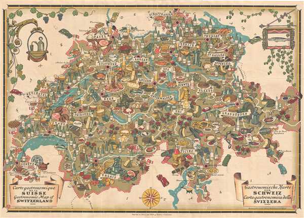
1939 Pictorial Swiss Tourism Gastronomical Map of Switzerland
GastronomicSwitzerland-tourisme-1939$200.00

Title
Carte Gastronomique de la Suisse. Gastronomic map of Switzerland. Gastronomische Karte der Schweiz. Carta gastronomica della Svizzera.
1939 (dated) 20 x 28 in (50.8 x 71.12 cm) 1 : 600000
1939 (dated) 20 x 28 in (50.8 x 71.12 cm) 1 : 600000
Description
This is a fascinating 1939 pictorial map of Switzerland depicting the cuisine of Switzerland. The map covers the entire country in striking detail. Notes cantons, rivers, lakes, and roads. The entire map is covered in numerous illustrations of food and drink, depicting the popular cuisine of the specific region, giving an incredible overview of the Swiss cuisine. These include cheeses, wines, ciders, liqueurs, beers, chocolate, bread, meat, etc.
Verso of the map features detailed text describing each canton and region as well as information relating to the Swiss pantry, its cheese, wines, chocolates, beers, etc. Printed by Roth and Sauter and published by the National Office of Tourism, Zurich, Switzerland (Office National Suisse du Tourisme a Zurich), this map was issued during the Swiss National Exposition of 1939 held in Zurich. An incredible gourmet guide to Switzerland.
Verso of the map features detailed text describing each canton and region as well as information relating to the Swiss pantry, its cheese, wines, chocolates, beers, etc. Printed by Roth and Sauter and published by the National Office of Tourism, Zurich, Switzerland (Office National Suisse du Tourisme a Zurich), this map was issued during the Swiss National Exposition of 1939 held in Zurich. An incredible gourmet guide to Switzerland.
Condition
Very good. Minor wear along original fold lines. Minor foxing.