1730 Homann plan and view of Gdansk, Poland
Gdansk-homann-1730$950.00

Title
Prospect, Grundris und Gegend der Polnischen vesten Reichs und Handels-Stadt Dantzig und ihrem Werder.
1730 (dated) 18.75 x 22.25 in (47.625 x 56.515 cm) 1 : 106680
1730 (dated) 18.75 x 22.25 in (47.625 x 56.515 cm) 1 : 106680
Description
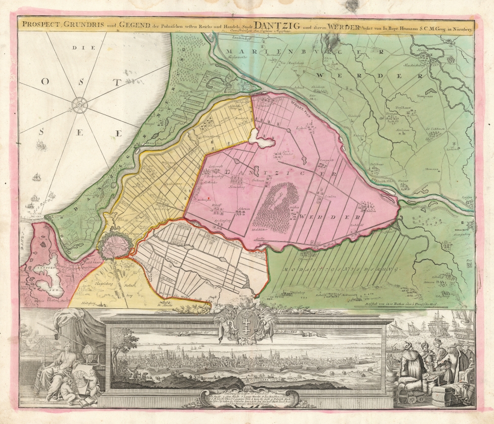
This is Johann Baptist Homann's map of Gdansk (here in the German 'Dantzig') and its immediate vicinity, first engraved and published about 1716. The east-oriented map portrays not only the walled city of Gdansk, but also the districts immediately to the East: the Gdansk Werder and the Marienburger Werder.
The left vignette is rather different. The seated woman with a fasces and a mural crown is an Italia Turrita, who originally represented Rome but later would be applied to represent cities generally. But rather than martial implements, this Italia is surrounded by instruments of astronomy: a telescope, a celestial globe, and an azimuthal quadrant. This is in reference to Gdansk's famous former city councilor and mayor, Johannes Hevelius (1611 - 1687). Hevelius was an illustrious astronomer, still hailed as the founder of lunar topography. His Gdansk observatory was the largest such institution in Europe until its 1679 destruction by fire. The quadrant pictured here was built by Hevelius, as was the long, suspended telescope - The image does not do justice to the device, it was forty-six meters long!
Dutch Settlements
The Danzig Werder and the Marienburer Werder constitute the center of the Vistula-Nogat delta. Much of the land they encompass lies from three to seven feet below sea level. Beginning in the 14th century, dikes were built on both sides of the Vistula allowing the land of the Werden to be cultivated, although the Vistula periodically broke through the dikes, and for much of the 16th century these areas were desolate and covered with water. In 1547, Dutch Mennonites proposed to move in and reclaim the land at their own expense. The Gdansk city council allowed the first settlers to establish a village at Reichenberg, now known as Bogatka (on the inland bank of the Martwa Wisła). Other villages were to follow. They were successful, and by 1575 the grain exports leaving Gdansk quadrupled. Dutch influence also extended to the introduction of superior Dutch breeds of cattle and horses. Their settlements, as well as the canals and windmills established to continue the water removal process, can be seen here.The View
At the bottom center of the engraving is an eastern-oriented prospect of Gdansk itself as seen from the heights to the west of the city. The image is crowned with the City Arms of Gdansk. Its churches, government buildings, and markets are identified by a numbered key. A note in the text indicates that the Swedish armies (besieging the city during the Second Northern War) overtook the city in 1657 by the expedient of breaching the dam and flooding the area.Allegorical Engraving
The map is embellished with two attractive vignettes. In the lower right is a busy harbor scene. In the background, ships come and go, while, in the foreground, merchants in the garb of many nations haggle over cargo and coin, proclaiming the simple message that in this city and its surrounds, money can be made.The left vignette is rather different. The seated woman with a fasces and a mural crown is an Italia Turrita, who originally represented Rome but later would be applied to represent cities generally. But rather than martial implements, this Italia is surrounded by instruments of astronomy: a telescope, a celestial globe, and an azimuthal quadrant. This is in reference to Gdansk's famous former city councilor and mayor, Johannes Hevelius (1611 - 1687). Hevelius was an illustrious astronomer, still hailed as the founder of lunar topography. His Gdansk observatory was the largest such institution in Europe until its 1679 destruction by fire. The quadrant pictured here was built by Hevelius, as was the long, suspended telescope - The image does not do justice to the device, it was forty-six meters long!
Publication History and Census
This map was engraved as early as 1712 for inclusion in the Homann atlases. There are several states of the plate, which shows evidence of having been reworked in addition to its having Homann's Imperial Privilege appended. The separate map is well represented in institutional collections and appears occasionally on the market.Cartographer
Johann Baptist Homann (March 20, 1664 - July 1, 1724) was the most prominent and prolific map publisher of the 18th century. Homann was born in Oberkammlach, a small town near Kammlach, Bavaria, Germany. As a young man, Homann studied in a Jesuit school and nursed ambitions of becoming a Dominican priest. Nonetheless, he converted to Protestantism in 1687, when he was 23. It is not clear where he mastered engraving, but we believe it may have been in Amsterdam. Homann's earliest work we have identified is about 1689, and already exhibits a high degree of mastery. Around 1691, Homann moved to Nuremberg and registered as a notary. By this time, he was already making maps, and very good ones at that. He produced a map of the environs of Nürnberg in 1691/92, which suggests he was already a master engraver. Around 1693, Homann briefly relocated to Vienna, where he lived and studied printing and copper plate engraving until 1695. Until 1702, he worked in Nuremberg in the map trade under Jacob von Sandrart (1630 - 1708) and then David Funck (1642 - 1709). Afterward, he returned to Nuremberg, where, in 1702, he founded the commercial publishing firm that would bear his name. In the next five years, Homann produced hundreds of maps and developed a distinctive style characterized by heavy, detailed engraving, elaborate allegorical cartouche work, and vivid hand color. Due to the lower cost of printing in Germany, the Homann firm could undercut the dominant French and Dutch publishing houses while matching their diversity and quality. Despite copious output, Homann did not release his first major atlas until the 33-map Neuer Atlas of 1707, followed by a 60-map edition of 1710. By 1715, Homann's rising star caught the attention of the Holy Roman Emperor Charles VI, who appointed him Imperial Cartographer. In the same year, he was also appointed a member of the Royal Academy of Sciences in Berlin. Homann's prestigious title came with several significant advantages, including access to the most up-to-date cartographic information as well as the 'Privilege'. The Privilege was a type of early copyright offered to very few by the Holy Roman Emperor. Though less sophisticated than modern copyright legislation, the Privilege offered limited protection for several years. Most all J. B. Homann maps printed between 1715 and 1730 bear the inscription 'Cum Priviligio' or some variation. Following Homann's death in 1724, the firm's map plates and management passed to his son, Johann Christoph Homann (1703 - 1730). J. C. Homann, perhaps realizing that he would not long survive his father, stipulated in his will that the company would be inherited by his two head managers, Johann Georg Ebersberger (1695 - 1760) and Johann Michael Franz (1700 - 1761), and that it would publish only under the name 'Homann Heirs'. This designation, in various forms (Homannsche Heirs, Heritiers de Homann, Lat Homannianos Herod, Homannschen Erben, etc.) appears on maps from about 1731 onwards. The firm continued to publish maps in ever-diminishing quantities until the death of its last owner, Christoph Franz Fembo (1781 - 1848). More by this mapmaker...
Source
Homann, J. B. and Homann, J. C., Neuer Atlas bestehend in einig curieusen Astronomischen Kuppren und vielen auserlesenen accuratensten Land-Charten über die Gantze Welt, (Nuremberg: Homann), 1728.
Homann's Neuer Atlas bestehend in einig curieusen Astronomischen Kuppren und vielen auserlesenen accuratensten Land-Charten über die Gantze Welt was first publihsed in 1707 with 33 maps. A second edition followed in 1710 with 60 maps. Subsequent editions followed until about 1730. The title page notes proudly that the atlas features measurements based on the 'Copernican principle of the moving sky', a truly state-of-the-art innovation for the period. Regardless of editions, collations of the atlas are inconsistent, with some examples having less, while others have more maps - a consequence of the fact that the map sheets were delivered loose, to be bound at the buyer's discretion, and so some buyers chose to omit maps they did not consider relevant, or add others they did. Between editions, the constituent maps, particularly of European regions, were regularly updated to reflect the most recent political events. The atlas continued to be published by Homann's son, J. C. Homann (1703 - 1730), and then by Homann Heirs. Most examples also feature a fine allegorical frontispiece with the title Atlas Novus Terrarum Orbis Imperia, regna et Status, which was used for multiple Homann atlases, including the Neuer Atlas and the Atlas Minor.
Condition
Very good. Faint toning. Some water staining in margin; two ink stains at top, one within image. Original wash and outline color.
References
OCLC 390758235. Rumsey 12499.162.