This item has been sold, but you can get on the Waitlist to be notified if another example becomes available, or purchase a digital scan.
1780 Raynal and Bonne Map of Mascarene Islands: Reunion, Mauritius, Bourbon
GeneralesIsles-bonne-1780$100.00

Title
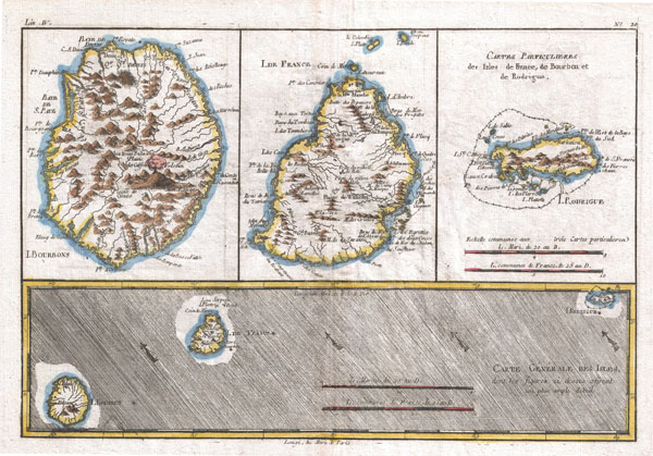
Carte Generale Des Isles
1780 (undated) 9 x 13 in (22.86 x 33.02 cm)
1780 (undated) 9 x 13 in (22.86 x 33.02 cm)
Description
A fine example of Rigobert Bonne and Guilleme Raynal's 1780 map of the Reunion (Ile. Bourbon), Mauritius (Ile. de France), and Rodrigues Islands, collectively known as the Mascarene Islands. Essentially four maps in one, the first map shows Reunion (Bourbon) Island. This map includes inland mountain ranges, featuring an erupting volcano in profile, and a detailed coastline with cities, rivers and ports. The center-most map details Mauritius Island (Ile. de France). Shows major cities and rivers and a detailed coast-line, including reefs, shoals, and other underwater dangers. The third map focuses on Rodrigues Island (Rodrigue Island.) Features mountain ranges, cities, and the barrier reef surrounding the island. Drawn by R. Bonne for G. Raynal's Atlas de Toutes les Parties Connues du Globe Terrestre, Dressé pour l'Histoire Philosophique et Politique des Établissemens et du Commerce des Européens dans les Deux Indes.
Cartographer
Rigobert Bonne (October 6, 1727 - September 2, 1794) was one of the most important French cartographers of the late 18th century. Bonne was born in Ardennes à Raucourt, France. He taught himself mathematics and by eighteen was a working engineer. During the War of the Austrian Succession (1740 - 1748) he served as a military engineer at Berg-op-Zoom. It the subsequent years Bonne became one of the most respected masters of mathematics, physics, and geography in Paris. In 1773, Bonne succeeded Jacques-Nicolas Bellin as Royal Cartographer to France in the office of the Hydrographer at the Depôt de la Marine. Working in his official capacity, Bonne compiled some of the most detailed and accurate maps of the period - most on an equal-area projection known erroneously as the 'Bonne Projection.' Bonne's work represents an important step in the evolution of the cartographic ideology away from the decorative work of the 17th and early 18th century towards a more scientific and practical aesthetic. While mostly focusing on coastal regions, the work of Bonne is highly regarded for its detail, historical importance, and overall aesthetic appeal. Bonne died of edema in 1794, but his son Charles-Marie Rigobert Bonne continued to publish his work well after his death. More by this mapmaker...
Source
Raynal, G., Atlas de Toutes les Parties Connues du Globe Terrestre, Dressé pour l'Histoire Philosophique et Politique des Établissemens et du Commerce des Européens dans les Deux Indes, 1780.
Condition
Very good. Original centerfold. Platemark visible. Blank on verso.