1716 Homann Map of Genoa, Italy
Genoa-homann-1716$1,000.00
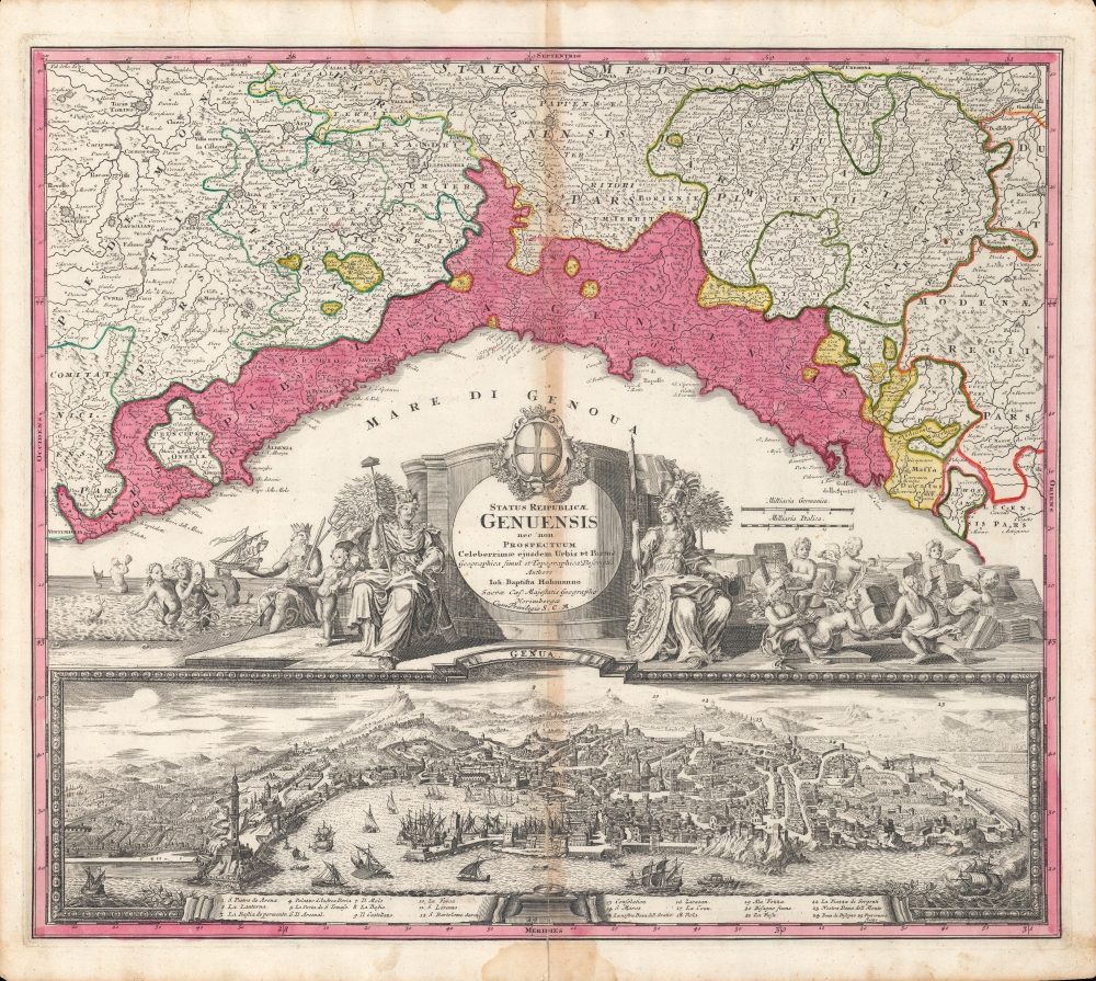

Title
Status Reipublicæ Genuensis nec non Prospectuum Celeberrimæ ejusdem Urbis et Portus Geographica simul et Topographica Descriptio.
1716 (undated) 19.25 x 21.25 in (48.895 x 53.975 cm) 1 : 600000
1716 (undated) 19.25 x 21.25 in (48.895 x 53.975 cm) 1 : 600000
Description
A beautiful old-color example of Johann Baptist Homann's c. 1716 map of the Republic of Genoa. Its appealing layout combines both a map and a view, along with an elaborate cartouche and vignettes.
The center portion of the sheet is an elaborate title cartouche including the republic's coast of arms as well as vignettes of mythical figures such as winged cherubs and Poseidon. The bottom third of the sheet is taken up by a view of the city, accompanied by a key. Churches, fortifications, and geographic features are noted, but perhaps most impressive is the Lighthouse of Genoa ('La Lanterna') at left in the foreground, first constructed in 1543 and still standing today. Until the 20th century, it was the tallest lighthouse in the world, at nearly 400 feet tall.
A Closer Look
The sheet is divided roughly into thirds, with the top third being a map of Genoa and its hinterland. To the north, west, and east of the city are numerous fortresses. Towns, villages, churches, waterways, mountains, and territorial borders are indicated throughout, demonstrating complex territorial divisions such as exclaves and enclaves. Yellow enclaves with double-headed eagle symbols represent the Holy Roman Emperor, to whom Genoa was nominally subject.The center portion of the sheet is an elaborate title cartouche including the republic's coast of arms as well as vignettes of mythical figures such as winged cherubs and Poseidon. The bottom third of the sheet is taken up by a view of the city, accompanied by a key. Churches, fortifications, and geographic features are noted, but perhaps most impressive is the Lighthouse of Genoa ('La Lanterna') at left in the foreground, first constructed in 1543 and still standing today. Until the 20th century, it was the tallest lighthouse in the world, at nearly 400 feet tall.
Publication History and Census
This map was produced by Johann Baptist Homann, and dates to between 1715 (when Homann became Imperial Geographer) and 1730 (as indicated by the phrase 'cum privilegio' in the title cartouche). It appeared in Homann's Grosser Atlas über die Ganze Welt and might have also been issued separately. Uncertainty over the date has led to its being cataloged in fourteen separate OCLC listings. However, each listing notes it at only a small number of institutions, perhaps fifteen in all, most of which are in continental Europe. In North America, only the Newberry Library and the University of Wisconsin-Milwaukee hold the map.Cartographer
Johann Baptist Homann (March 20, 1664 - July 1, 1724) was the most prominent and prolific map publisher of the 18th century. Homann was born in Oberkammlach, a small town near Kammlach, Bavaria, Germany. As a young man, Homann studied in a Jesuit school and nursed ambitions of becoming a Dominican priest. Nonetheless, he converted to Protestantism in 1687, when he was 23. It is not clear where he mastered engraving, but we believe it may have been in Amsterdam. Homann's earliest work we have identified is about 1689, and already exhibits a high degree of mastery. Around 1691, Homann moved to Nuremberg and registered as a notary. By this time, he was already making maps, and very good ones at that. He produced a map of the environs of Nürnberg in 1691/92, which suggests he was already a master engraver. Around 1693, Homann briefly relocated to Vienna, where he lived and studied printing and copper plate engraving until 1695. Until 1702, he worked in Nuremberg in the map trade under Jacob von Sandrart (1630 - 1708) and then David Funck (1642 - 1709). Afterward, he returned to Nuremberg, where, in 1702, he founded the commercial publishing firm that would bear his name. In the next five years, Homann produced hundreds of maps and developed a distinctive style characterized by heavy, detailed engraving, elaborate allegorical cartouche work, and vivid hand color. Due to the lower cost of printing in Germany, the Homann firm could undercut the dominant French and Dutch publishing houses while matching their diversity and quality. Despite copious output, Homann did not release his first major atlas until the 33-map Neuer Atlas of 1707, followed by a 60-map edition of 1710. By 1715, Homann's rising star caught the attention of the Holy Roman Emperor Charles VI, who appointed him Imperial Cartographer. In the same year, he was also appointed a member of the Royal Academy of Sciences in Berlin. Homann's prestigious title came with several significant advantages, including access to the most up-to-date cartographic information as well as the 'Privilege'. The Privilege was a type of early copyright offered to very few by the Holy Roman Emperor. Though less sophisticated than modern copyright legislation, the Privilege offered limited protection for several years. Most all J. B. Homann maps printed between 1715 and 1730 bear the inscription 'Cum Priviligio' or some variation. Following Homann's death in 1724, the firm's map plates and management passed to his son, Johann Christoph Homann (1703 - 1730). J. C. Homann, perhaps realizing that he would not long survive his father, stipulated in his will that the company would be inherited by his two head managers, Johann Georg Ebersberger (1695 - 1760) and Johann Michael Franz (1700 - 1761), and that it would publish only under the name 'Homann Heirs'. This designation, in various forms (Homannsche Heirs, Heritiers de Homann, Lat Homannianos Herod, Homannschen Erben, etc.) appears on maps from about 1731 onwards. The firm continued to publish maps in ever-diminishing quantities until the death of its last owner, Christoph Franz Fembo (1781 - 1848). More by this mapmaker...
Condition
Good. Soiling and wear along centerfold.
References
OCLC 952498166. Christian Sandler, 'Johann Baptista Homann. ein Beitrag zue Geschichte der Kartographie' in Zeitschrift : Gesellschaft für Erdkunde zu Berlin (Berlin: Dietrich Reimer, 1886), 347-348.