This item has been sold, but you can get on the Waitlist to be notified if another example becomes available, or purchase a digital scan.
1854 Blake Geological Route Map of the American West: Mississippi River to Los Angeles
Geological-blake-1854$75.00

Title
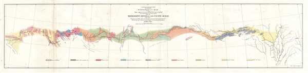
Geological Map of the Route Explored by Lieut. A. W. Whipple, Corps of Topographical Engineers near the parallel of 35 degrees North Latitude from the Mississippi River to the Pacific Ocean. 1853-1854.
1854 (dated) 9 x 38 in (22.86 x 96.52 cm) 1 : 3000000
1854 (dated) 9 x 38 in (22.86 x 96.52 cm) 1 : 3000000
Description
This is an 1854 William Phipps Blake geological map of the American West prepared for the War Department's Pacific Railroad explorations and surveys. The map depicts the western United States from Memphis, Tennessee and the Mississippi River west to Los Angeles, California. A key along the bottom border explains the 9 different geological features that are depicted, including granite and metamorphic formations, gypsum formations, and alluvial and detritus formations. Lieutenant A. W. Whipple of the Corps of Topographical Engineers used this route to explore one of the potential routes for the railroad from the Mississippi River to the Pacific. He followed the Arkansas River and the Canadian River to its headwaters and then continued west across the Llano Estacado, across the Pecos River and the Rio Grande, and along the edge of the Mogollon Rim, labeled here as the Sierra Mogoyon, through the Sonoran Desert to Los Angeles. Several cities are labeled, including Pine Bluff, Little Rock and Fort Defiance.
This map was created by William P. Blake from the notes and collections of the geologist of the expedition Mr. Jules Marcou in the Office of Pacific Rail Road Explorations and Surveys, War Department in 1854 and printed by A. Hoen and Company of Baltimore
This map was created by William P. Blake from the notes and collections of the geologist of the expedition Mr. Jules Marcou in the Office of Pacific Rail Road Explorations and Surveys, War Department in 1854 and printed by A. Hoen and Company of Baltimore
CartographerS
William Phipps Blake (June 1, 1826 – May 22, 1910) was an American geologist, mining consultant, and educator. Blake has been credited with being 'the first college trained chemist employed full-time in American industry' before graduating from Yale. Selected as the mineralogist and geologist of the Pacific Railroad Exploring Expedition in 1853, Blake made several important discoveries, including studying the erosive effects of wind-blown sand in San Gorgonio Pass in California. Several of the sketches he produced for the Railroad Survey reports are not highly sought after as works of art. Over the course of his career, Blake served in several different official government posts, including as the California representative to the Exposition Universelle in Paris in 1867 and to collect and install the mineral exhibit at the Philadelphia Centennial Exposition. Blake also became a sought-after expert witness for testimony in court cases involving the geology of mineral deposits. His final stop in a long an illustrious career was at the University of Arizona, where he served as a Professor of Geology and as Director of the School of Mines. More by this mapmaker...
August Hoen and Company (fl. c. 1840 - 1981) was a Baltimore based engraving and lithography firm active in the middle part of the 19th century. A. Hoen and Co. was originally founded by Edward Weber under the name 'E. Weber and Company.' Weber died in the early 1850s and his company was taken over by German immigrant August Hoen (18?? - 1886) and his brothers, Henry and Ernest Hoen. As general interest lithographers, the Hoen firm's corpus includes posters, cigar boxes, sheet music covers, and posters as well as maps. They are best known for their pioneering multi-color lithographic techniques. After the death of August Hoen, the business passed on to his son, Albert Hoen. Another son, Earnest A. Hoen, moved to Richmond, Virginia and opened a branch of the firm there where he was granted a charter to produce Civil War era Confederate Currency. Their contributions to the cartographic field are generally in association with engraving and printing work done for Jacob Monk and the U.S. Geological Survey. The Hoen family maintained an active interest in the firm for the next 100 years or so until it finally filed for bankruptcy in 1981. Learn More...
Condition
Very good. Wear along original fold lines. Blank on verso.
References
OCLC 53803051.