1938 Map of Penang, George Town, Malaysia
GeorgeTownPenang-unknown-1938$400.00

Title
George Town, Penang.
1938 (dated) 14.25 x 19.25 in (36.195 x 48.895 cm) 1 : 12700
1938 (dated) 14.25 x 19.25 in (36.195 x 48.895 cm) 1 : 12700
Description
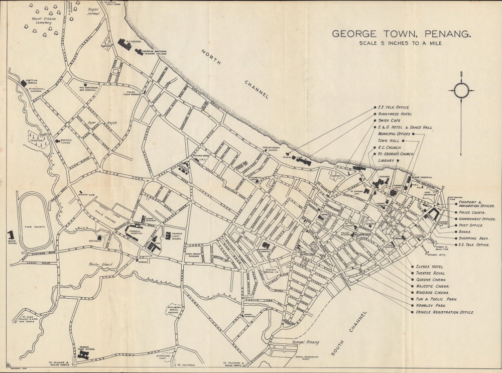
A rare 1938 map of Penang, George Town that appeared in the Penang Information Guide. It reflects the city's diversity as well as the foundations of British colonial rule.
Like other colonial entrepôts and treaty ports in East and Southeast Asia, George Town became known for its cosmopolitanism as well as its vice, particularly organized crime. Various communities contributed to its culture, while also comingling (the city had a visible and important 'Eurasian' minority of mixed-race heritage). Amid this diversity, however, there was racial discrimination and stratification. After the small number of British residents, other white settlers, and mixed-race 'Eurasians,' the Chinese, who primarily engaged in commercial activity, were generally better-off than Indians, who performed 'coolie' labor, and Malays, who primarily produced food through farming and fishing. The British crafted immigration and education policies that reinforced these divisions, further strengthening their preconceptions about the proper role of each group, while also inadvertently stoking tensions between these communities. Although inequality has improved since independence, the continued relative wealth of the Chinese community and the resentment it has provoked has often been a central tension in Malaysian politics, though recent elections suggest that this is changing.
Malaya was an important piece in Britain's global empire, especially as a source of tin and rubber, which also made the peninsula a target for a Japanese invasion in late 1941. Britain's defense of the peninsula was disastrous, culminating in the embarrassing surrender of Singapore, with Penang being captured less than two weeks after the Japanese invasion of Malaya began. The occupation was trying for all inhabitants, but especially ethnic Chinese communities who suffered wholesale massacres at the hands of Japanese troops. After the war, as elsewhere, Britain found it difficult to reassert control and was forced to undertake moves towards independence.
A Closer Look
The main portion of George Town is included, with reference to temples and a funicular hill railway beyond the scope of the map to the southwest. Recreation sites such as cinemas, parks, a racecourse, and polo grounds are prominently indicated, as are police and immigration facilities, including a dedicated 'Indian Immigration Depot.' Varied social clubs, religious sites, and cemeteries reveal the cosmopolitanism of George Town. Fort Cornwallis, situated at a point jutting out into the sea in the northeast corner of the city, was built by the British East India Company in the late 18th and early 19th century. Though imposing, it never saw combat and was designated a historic site in the 1970s.George Town: Crossroads of Cultures
Britain acquired Penang Island in the late 18th century from the Kedah after offering military assistance to the Sultan, who was then facing both internal and external struggles. Initially conceived of as a stopover for naval vessels between India and China, Penang and its main settlement at George Town rapidly developed into a commercial center, aided by the free trade policies implemented by Francis Light, the founder of the colony. It first became an important center for the spice trade, then developed additional industries during the 19th century, and later attracted banks and other financial institutions, such as the Hong Kong and Shanghai Bank (HSBC) and the Chartered Bank (of India, Australia and China) seen here. Due to its laissez-faire atmosphere, Penang became a destination for writers, revolutionaries, and drifters.Like other colonial entrepôts and treaty ports in East and Southeast Asia, George Town became known for its cosmopolitanism as well as its vice, particularly organized crime. Various communities contributed to its culture, while also comingling (the city had a visible and important 'Eurasian' minority of mixed-race heritage). Amid this diversity, however, there was racial discrimination and stratification. After the small number of British residents, other white settlers, and mixed-race 'Eurasians,' the Chinese, who primarily engaged in commercial activity, were generally better-off than Indians, who performed 'coolie' labor, and Malays, who primarily produced food through farming and fishing. The British crafted immigration and education policies that reinforced these divisions, further strengthening their preconceptions about the proper role of each group, while also inadvertently stoking tensions between these communities. Although inequality has improved since independence, the continued relative wealth of the Chinese community and the resentment it has provoked has often been a central tension in Malaysian politics, though recent elections suggest that this is changing.
From Malaya to Malaysia
British Malaya was a combination of quasi-independent protectorates like Kedah (the Unfederated States), more directly controlled but still nominally autonomous Federated States (based in Kuala Lumpur), and the Straits Settlements (Singapore, Penang, Malacca, and Dinding), which were crown colonies. Though all were enmeshed in a wider colonial system and often considered as part of a single entity, this tripartite system lasted until after the Second World War.Malaya was an important piece in Britain's global empire, especially as a source of tin and rubber, which also made the peninsula a target for a Japanese invasion in late 1941. Britain's defense of the peninsula was disastrous, culminating in the embarrassing surrender of Singapore, with Penang being captured less than two weeks after the Japanese invasion of Malaya began. The occupation was trying for all inhabitants, but especially ethnic Chinese communities who suffered wholesale massacres at the hands of Japanese troops. After the war, as elsewhere, Britain found it difficult to reassert control and was forced to undertake moves towards independence.
Publication History and Census
This map, dated December 1938, appeared in the Penang Information Guide, a monthly publication on behalf of the Municipal Commissioners of George Town. The initials 'S.T.Y.' appear at bottom-left, perhaps denoting the map's creator. It is not independently cataloged in the holdings of any institution, while 1938 issues of the Penang Information Guide are held by the National Library of Malaysia.Condition
Very good. Slight wear on old fold liens. Light foxing and offsetting at left.
References
OCLC 850293784 (Penang Information Guide).