This item has been sold, but you can get on the Waitlist to be notified if another example becomes available, or purchase a digital scan.
1861 Mitchell Map of Georgia and Alabama
GeorgiaAlabama-mitchell-1861$62.50

Title
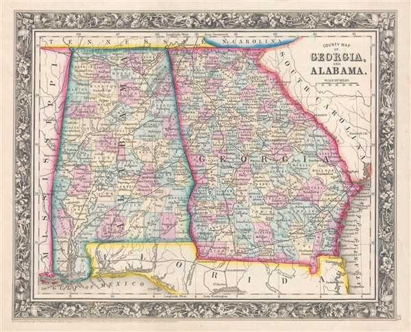
County Map of Georgia, and Alabama.
1860 (dated) 11.25 x 14 in (28.575 x 35.56 cm) 1 : 2661120
1860 (dated) 11.25 x 14 in (28.575 x 35.56 cm) 1 : 2661120
Description
This is an 1861 Samuel Augustus Mitchell, Jr. map of Georgia and Alabama. The map depicts the region from Mississippi to the Atlantic Ocean and South Carolina and from Tennessee, North Carolina, and South Carolina to Florida and the Gulf of Mexico.
Georgia and the American Civil War
Three years after this map's publication, the city of Atlanta lay in ruins, burned to the ground by General Sherman's army in order to deprive Confederate armies of any support that it could offer. Atlanta had played a key role in supporting the Confederate war effort, bustling city full of factories that produced cannons, pistols, swords, uniforms, leather goods, and even iron plating for the Confederate Navy Ironclads. Atlanta was also a major transportation hub, with several railroads converging in the city, such as the Western and Atlantic Railroad, which connected Atlanta and Chattanooga, Tennessee, the Georgia Railway, which operated between Atlanta and Augusta, the Macon and Western, which operated between Atlanta, Macon, and Savannah, and the Atlanta and West Point Railroad, which connected Atlanta and West Point, Georgia. At West Point, a connection was made with the Western Railway of Alabama, which linked Atlanta to Montgomery. These four railroads are illustrated here, although are labeled. All of these factors led to the Union's desire to capture the city and end the support it provided for the Confederate army. Sherman's capture of Atlanta in September 1864 also proved to be a vital victory in the war and one of the deciding factors in President Lincoln's electoral victory in the election of 1864 in November.
Individual counties are illustrated, labeled, and shaded different colors to allow for easy differentiation in both Indiana and Ohio. Cities, such as Atlanta, Augusta, Macon, Savannah, Athens, Montgomery, and Mobile are labeled, along with myriad other towns and villages. Rivers, creeks, and lakes are illustrated as well, though not all are labeled. Both Mobile Bay and Pensacola Bay are illustrated and labeled as well.
This map was prepared by S. A. Mitchell Jr. for inclusion in the 1861 edition of Mitchell's New General Atlas. Like many American map publishers of this period, Mitchell did not regularly update his copyrights, consequently this map is dated and copyrighted to 1860: 'Entered according to Act of Congress in the Year 1860 by S. Augustus Mitchell Jr. in the Clerk's Office of the District Court of the U.S. for the Eastern District of Pennsylvania.'
Cartographer
Samuel Augustus Mitchell (March 20, 1792 - December 20, 1868) began his map publishing career in the early 1830s. Mitchell was born in Bristol, Connecticut. He relocated to Philadelphia in 1821. Having worked as a school teacher and a geographical writer, Mitchell was frustrated with the low quality and inaccuracy of school texts of the period. His first maps were an attempt to rectify this problem. In the next 20 years Mitchell would become the most prominent American map publisher of the mid-19th century. Mitchell worked with prominent engravers J. H. Young, H. S. Tanner, and H. N. Burroughs before attaining the full copyright on his maps in 1847. In 1849 Mitchell either partnered with or sold his plates to Thomas, Cowperthwait and Company who continued to publish the Mitchell's Universal Atlas. By about 1856 most of the Mitchell plates and copyrights were acquired by Charles Desilver who continued to publish the maps, many with modified borders and color schemes, until Mitchell's son, Samuel Augustus Mitchell Junior, entered the picture. In 1859, S.A. Mitchell Jr. purchased most of the plates back from Desilver and introduced his own floral motif border. From 1860 on, he published his own editions of the New General Atlas. The younger Mitchell became as prominent as his father, publishing maps and atlases until 1887, when most of the copyrights were again sold and the Mitchell firm closed its doors for the final time. More by this mapmaker...
Source
Mitchell, S. A., Mitchell's New General Atlas Containing Maps of the Various Countries of the World, Plans of Cities, Etc., embraced in Forty-Seven Quarto Maps, Forming a series of Seventy-Six Maps and Plans, together with Valuable Statistical Tables (Philadelphia: S. Augustus Mitchell, Jr.) 1861.
Mitchell's New General Atlas was published by Samuel Augustus Mitchell, Jr., the son of the prolific cartographer Samuel Augustus Mitchell. Many of the plates are derived from the his father's Mitchell's Universal Atlas, but not directly. The Mitchell's Universal Atlas was initially sold to Thomas, Cowperthwait, and Company in 1849, and again to Charles Deliver in 1856. It was Deliver who introduced the new vibrant color scheme, abandoning the older Mitchell's Universal Atlas green borders and themes for bright reds, blues, and yellows. Samuel Augustus Mitchell, Jr. acquired the Deliver plates in 1859. He added his own floral motif border, but doubled down on the vibrant color scheme, thus introducing to the American public the most vividly colored American atlas of the 19th century. In 1860, he published the first edition of his New General Atlas and, despite a slump in sales during the American Civil War, attained a level of success to rival his father. Mitchell would continue to publish the New General Atlas until 1887, when the firm formally closed.
Condition
Very good. Even overall toning. Blank on verso.
References
Rumsey 0565.017 (1860 edition).