1944 Chapin Map of Germany
GermanJigsaw-chapin-1944$350.00


Title
German Jigsaw.
1944 (dated) 34.5 x 36.25 in (87.63 x 92.075 cm) 1 : 11650000
1944 (dated) 34.5 x 36.25 in (87.63 x 92.075 cm) 1 : 11650000
Description
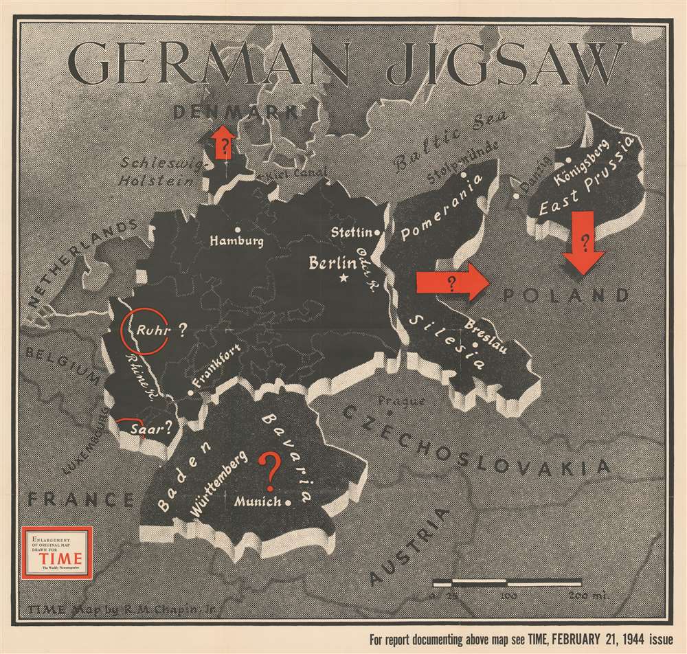
This separate-issue large-format Robert M. Chapin Jr. map of World War II Germany speculates about the fate of a post-war Germany. It was published at the end of February 1944, three months before D-Day.
Germany as a Giant Puzzle
The map depicts Germany's borders just after World War I (1914 - 1918) before the rise of Adolf Hitler, the Nazi Party, and the Third Reich, and uses red arrows to suggest the future of certain 'pieces' of Germany. At the time, it was theorized that by breaking up Germany, it would prevent Germans from ever having the industrial capability to launch another World War. Here, eastern Germany and East Prussia are 'given' to Poland, Schleswig-Holstein is made part of Denmark, and Bavaria is granted independence, possibly reluctantly. The Ruhr and the Saar, two industrial regions in western Germany, are included in a larger northern German state. However, TIME also presents the possibility that these regions would clamor for independence, which they point out would be the opposite reaction of the Bavarians.Tensions between the Allies - How Will Ideological Differences Affect the Post-War World?
Printed three months before the Allied D-Day invasion in Normandy, TIME presents the already contentious relationship between the Western Allies and the Soviet Union. These tensions would ultimately lead to the Cold War, but here are a vacuum of unknowns surrounding a post-war Germany.Publication History and Census
This map was drawn by Robert M. Chapin Jr. for publication in the February 21, 1944 issue of TIME Magazine. The present example is a separate-issue enlargement of that map. It bears a collection stamp from the Ashtabula Public Library in Ohio on verso. We have contacted the library and confirmed that it was deaccessioned. We note 4 examples are cataloged in the OCLC: Franklin and Marshall College, the University of Michigan, the University of Chicago, and the University of Illinois at Urbana-Champaign.Cartographer
Robert M. Chapin Jr. (fl. 1933 - 1970) was a prominent architect, cartographer and illustrator active during World War II and the Cold War. Chapin graduated from the University of Pennsylvania in 1933 with a degree in architecture. Since this was the height of the Great Depression, and architects in low demand, he instead took work as a staff cartographer at Newsweek. Catching the attention of Manfred Gottfried of Time, Chapin was offered an accepted a position at the head of Time's cartography department. He remained with Time for some 33 years, from 1937 to 1970, often drawn 2 - 3 new thematic maps weekly. With an architect's gift visualizing information, Chapin became a skilled informational cartographer, heading the cartography department at Time Magazine. Chapin, like Fortune Magazine chief cartographer, Richard Edes Harrison, Chapin was at the forefront of infographic propaganda cartography, a genre that matured during the World War II Era and remains popular today. Working for Time Magazine, Chapin developed a signature style for his long run of 'War Maps.' Chapin was known for his maverick airbrush technique which lead to strong color splashes and intense shading. He also incorporated celluloid stencils to illustrate bomb explosions, flags, sinking ships, and more - generating a instantly recognizable standardized style. Chapin's Time war maps were further distinctive for their use of strong bold reds as a universal symbol of hostility. Chapin graduated from the University of Pennsylvania in 1933 with a degree in architecture. Since this was the height of the Great Depression, an d architects in low demand, he instead took work as a staff cartographer at Newsweek. Catching the attention of Manfred Gottfried of Time, Chapin was offered an accepted a position at the head of Time's cartography department. He remained with Time for some 33 years, from 1937 to 1970, often drawn 2 - 3 new thematic maps weekly. Chapin live in Sharon Connecticut. More by this mapmaker...
Condition
Fair. Wear, verso repairs, and slight intersection loss along original fold lines. Stabilized. Bears collection stamp from the Ashtabula Public Library in Ohio on verso. We have contacted the library and confirmed that it was legally deaccessioned.
References
OCLC 68915666.