This item has been sold, but you can get on the Waitlist to be notified if another example becomes available, or purchase a digital scan.
1857 Stieler Physical Map of Central Europe
GermanyMountainsRivers-stieler-1873$50.00

Title
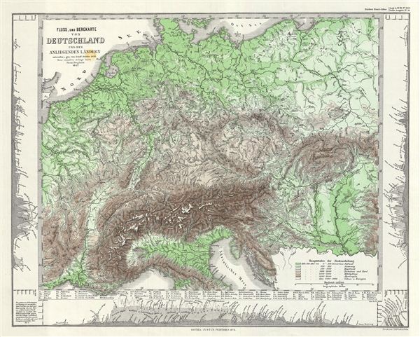
Fluss uund Bergkarte von Deutschland und den anliegenden Landern.
1873 (dated) 14 x 17 in (35.56 x 43.18 cm)
1873 (dated) 14 x 17 in (35.56 x 43.18 cm)
Description
This is a beautiful example of Stieler's 1857 physical map of the rivers and mountains of Germany and its neighboring countries. It covers from Denmark to the northern part of Italy and includes the modern day countries of Germany, Netherlands, Belgium, Czech Republic, Austria, Switzerland, Slovenia, Croatia and parts of France, Poland and Italy. The map is surrounded on three sides by elevations of the various mountain ranges. Map is densely detailed with both political and physical data. Various cities, mountains, roads, rivers and an assortment of additional topographical details are noted. Printed to a high production standard, as was typical of German and especially Perthes/Stieler maps of this period. Published by the Justus Perthes firm for issue in the 1873 edition of Stieler's Hand-Atlas.
Cartographer
Johan Georg Justus Perthes (September 11, 1749 - May 2, 1816) was one of the most important German cartographic engravers of the 19th century. He was born in the Thuringian town of Rudolstadt, the son of a court physician. In 1778, he began working as a bookseller in Gotha. Perthes began his publishing empire shortly thereafter with the 1784 issue of the famed survey of European nobility known as the Almanac de Gotha. In the next year, 1785, he founded the cartographic firm of Justus Perthes Geographische Anstalt Gotha. His son Wilhelm Perthes (1793 - 1853) joined the firm in 1814. Wilhelm had prior publishing experience at the firm of Justus Perthes' nephew, Friedrich Christoph Perthes, who ran a publishing house in Hamburg. After Justus Perthes died in 1816, Wilhelm took charge and laid the groundwork for the firm to become a cartographic publishing titan. From 1817 to 1890. the Perthes firm issued thousands of maps and more than 20 different atlases. Along with the visionary editors Hermann Berghaus (1797 - 1884), Adolph Stieler (1775 - 1836), and Karl Spruner (1803 - 1892), the Perthes firm pioneered the Hand Atlas. When Wilhelm retired, management of the firm passed to his son, Bernhardt Wilhelm Perthes (1821 – 1857). Bernhardt brought on the cartographic geniuses August Heinrich Peterman (1822 - 1878) and Bruno Hassenstein (1839 - 1902). The firm was subsequently passed to a fourth generation in the form of Berhanrd Perthes (1858 – 1919), Bernhard Wilhelm's son. The firm continued in the family until 1953 when, being in East Germany, it was nationalized and run as a state-owned enterprise as VEB Hermann Haack Geographisch-Kartographische Anstalt Gotha. The Justus family, led by Joachim Justus Perthes and his son Wolf-Jürgen Perthes, relocated to Darmstadt where they founded the Justus Perthes Geographische Verlagsanstalt Darmstadt. More by this mapmaker...
Source
Stieler, A., Stieler's Hand-Atlas (Germany, Perthes) 1873.
Condition
Very good. Blank on verso. Original platemark visible. Original centerfold exhibits slight wear.
References
Rumsey 2449.016.