1936 Walter Riemer Pictorial Propaganda / Tourist Map of Germany
GermanyTravelDutch-riemer-1936$650.00

Title
Het Mooie Deutschland.
1936 (undated) 22.5 x 31 in (57.15 x 78.74 cm) 1 : 1654000
1936 (undated) 22.5 x 31 in (57.15 x 78.74 cm) 1 : 1654000
Description
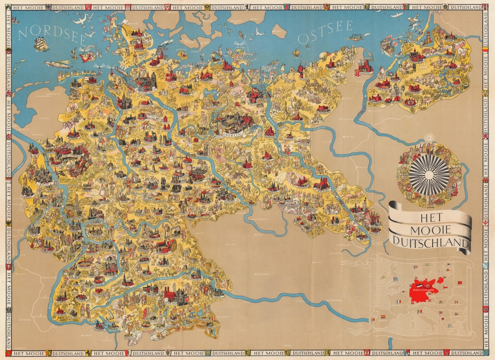
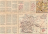
This is a 1936 Dutch edition Walter Riemer pictorial propaganda / tourist map of Nazi Germany published to promote the 1936 Berlin Olympic Games. An Olympian holding aloft a laurel crown appears next to a banner in Berlin.
An inset map of Europe is situated in the lower right corner, with Germany (Deutschland) dominating the map in red. Each of the other countries in Europe is labeled by its German name and its flag. A border around the map repeats the phrase 'Het Mooie Deutschland' and includes illustrations of the coats of arms of numerous German cities. Located above the inset map is an illustrated compass rose highlighting the achievements of German society.
A Map of Nazi Germany
The map depicts Germany from its western border with France, Luxembourg, Belgium, and the Netherlands to its eastern border with Poland and from the North Sea to its southern border with Austria and Czechoslovakia. The most striking and disturbing (with the benefit of history) aspect of the map is the plethora of swastikas and Nazi flags. Nuremberg, for example, was home of the Congresses of the Nazi Party, and a phalanx of Brownshirts carrying a Nazi flag is illustrated there. Other cities marked by flags include Munich and Berlin, while ships in the North Sea near Schleswig fly the flag, along with two airships near Stolp in northwest Germany, and a procession of people (who appear to be on parade) near Hannover. The only indication of the conflagration to come is the presence of the Nazi flag.A Closer Look
The presence of that hateful symbol aside, the map is highly detailed and beautifully produced. Cities and towns throughout are illustrated. Berlin is one of the most detailed, with the Brandenburg Gate and the Berlin Cathedral (Berliner Dom) recognizable. Other cities include recognizable buildings or historical figures, such as an illustration of Martin Luther in Wittenberg and the Frauenkirche in Munich (Munchen). A wagon of beer is also illustrated near Munich. Numerous other cities and towns include cathedrals and other buildings drawn in profile or a portrait of a famous citizen. Townspeople and vacationers appear throughout, giving Germany the aspect of a welcoming land. Livestock are included, along with some wild animals, such as a moose near Tilsit. Outside of Germany, several cities in France, Austria, Czechoslovakia, and Poland are labeled, including Vienna, Salzburg, and Innsbruck in Austria; Strasbourg, Besançon, Nancy, and Metz in France; Prague (Praha) and Bratislava in Czechoslovakia; and Warsaw and Poznań in Poland.An inset map of Europe is situated in the lower right corner, with Germany (Deutschland) dominating the map in red. Each of the other countries in Europe is labeled by its German name and its flag. A border around the map repeats the phrase 'Het Mooie Deutschland' and includes illustrations of the coats of arms of numerous German cities. Located above the inset map is an illustrated compass rose highlighting the achievements of German society.
Verso Content
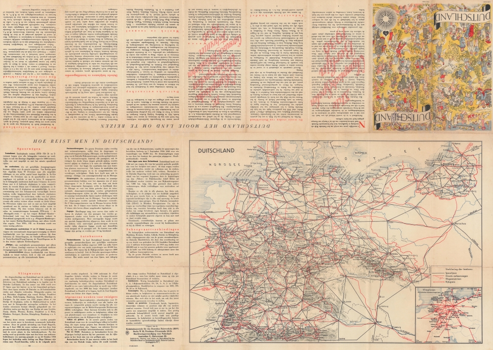
On the verso, practical information for tourists is provided in detail, describing the German 'Reich' and its cities, theatre, music, spas, and what money and visas are necessary when visiting Germany. Other information, pertaining to travel by train, plane, and automobile, is also included. A road map of Germany occupies a third of the verso, with smaller inset maps depicting Reich motor roads and the network of German airways in Europe.Publication History and Census
This map was created by Walter Riemer and published by the Reichsbahn Center for German Tourist Traffic (Reichbahnzentrale für den Deutschen Reiseverkehr) in 1936 and was also published in English. A second edition without the 1936 Olympic Games banner in Berlin was published in 1938, of which we have only seen an English edition. While cataloged examples of the 1936 English edition appear in OCLC, this is the only known cataloged example of the Dutch edition.Cartographer
Walter Riemer (1896 - 1942) was a German illustrator and painter. Riemer was active in Germany, producing political propaganda, advertising posters, stamps, bank notes, and other artwork, until 1942. He was a member of the Mitglied des Bundes Deutscher Gebrauchsgrafiker (Federation of German Commercial Artists). Riemer appears to have vanished (died?) at the start of World War II. More by this mapmaker...
Condition
Good. Wear along original fold lines. Slight loss at a few fold intersections. Verso repairs to separations at fold intersections. Old tape repairs evident on verso.