1762 Lattré map of the Fortifications on Gibraltar
Gibraltar-lattre-1762$700.00

Title
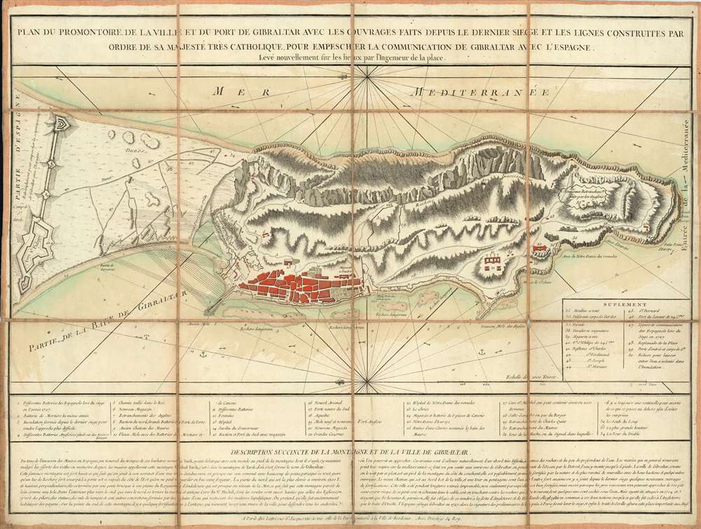
Plan du Promontoire de la Ville et du Port de Gibraltar avec les Ouvrages Faits Depuis le Dernier Siege et les Lignes Construites par Ordre de Sa Majesté très Catholique, pour Empescher la Communication de Gibraltar avec l'Espagne.
1762 (undated) 16 x 22 in (40.64 x 55.88 cm) 1 : 12000
1762 (undated) 16 x 22 in (40.64 x 55.88 cm) 1 : 12000
Description
This is a scarce, separately-issued c. 1770 Jean Lattré map of the town, port and peninsula of Gibraltar. This eastern-oriented map is richly detailed, showing the remarkable and forbidding topography of the peninsula and its fortifications. The map shows the positions held by the Spanish and the British during their long stalemate following the 1727 Spanish siege of Gibraltar. Lattré appears to have produced this map as a separate issue near the end of the Seven Years' War (1756 - 1763), coinciding with Spain's entrance to that conflict. Although the war ended without any action at Gibraltar, it would have been considered a possible theater of engagement.
State of the Map
This third state of the map we suspect to have been printed in the 1770s, following British modernization of the port's defenses. This state includes significant additional British fortification, and a 'Supplement' added to catalogue these changes. It may have been printed as late as Spain's 1779 declaration of war on Britain: since Spain's primary aim in entering that war was the recapture of Gibraltar, the update of this map would have been timely.Publication History and Census
This map is rare, and it is not well catalogued. As a consequence of it being an undated, separately issued map, there is no clear agreement on its dating among institutional collections. The map was listed among the offerings of Lattré's shop in the catalogue accompanying his 1762 Atlas moderne, so an approximate date of 1762 is warranted for the first printing.Other Examples
We have identified four states:- c. 1762 First state (see copy at the Institut Cartographic i Geologic de Catalunya, misdated 1770.) Lacks names for bodies of water, depth soundings.
- c. 1763 Second state (see Instituto Geographico Nacional: Adds 'Mer Mediterranee,' Partie de la Baye de Gibraltar,' depth soundings and anchorage off northwest coast. Lines of fire from Spanish batteries and fortifications to the North have also been added.
- c. 1770 (?) This state (our example) has significant additions. English fortifications on the southern heights of the peninsula are noted, as well as military positions throughout. A supplemental legend has been added to the lower right, detailing the newly added features. A scale has been added, and the notation 'rochers inaccessibles' is included on the cliffs dominating the eastern coast. More anchorages are also marked facing the western approaches to the port.
- c. 1783 (Princeton Historic Map Division, Special Collections, Firestone Library, misdated c. 1756) This state adds significant detail pertaining directly to the Grand Assault of the Great Siege of Gibraltar, including depictions of the floating batteries devised by French engineer Jean Le Michaud d'Arçon, so this state could not have been produced prior to 1782, and probably was not produced prior to the conclusion of the siege in 1783.
Cartographer
Jean Lattré (170x - 178x) was a Paris based bookseller, engraver, globe maker, calligrapher, and map publisher active in the mid to late 18th century. Lattré published a large corpus of maps, globes, and atlases in conjunction with a number of other important French cartographic figures, including Janvier, Zannoni, Bonne and Delamarche. He is also known to have worked with other European cartographers such as William Faden of London and the Italian cartographer Santini. Map piracy and copyright violations were common in 18th century France. Paris court records indicate that Lattré brought charges against several other period map publishers, including fellow Frenchman Desnos and the Italian map engraver Zannoni, both of whom he accused of copying his work. Lattré likes trained his wife Madame Lattré (né Vérard), as an engraver, as a late 18th century trade card promotes the world of 'Lattré et son Epouse.' Lattré's offices and bookshop were located at 20 rue St. Jaques, Paris, France. Later in life he relocated to Bordeaux. More by this mapmaker...
Condition
Very good. Dissected and laid down on original linen as issued. Original hand color. Minor soiling; some fraying of linen at a juncture of folds, else excellent.
References
OCLC 956285559.