This item has been sold, but you can get on the Waitlist to be notified if another example becomes available, or purchase a digital scan.
1747 Ratelband Map of Gibraltar
Gibraltar-ratelband-1747$150.00

Title
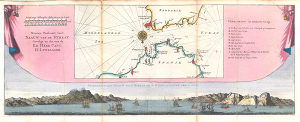
Nieuwe Paskaart Van't Naauw Van de Straat Gevolgt na die van de Ed: Heer Capt: H: Lynslager.
c. 1747 (undated) 7 x 18 in (17.78 x 45.72 cm)
c. 1747 (undated) 7 x 18 in (17.78 x 45.72 cm)
Description
This is an extremely scarce 1747 map of the Straits of Gibraltar. Depicts the Strait with a southward orientation, Spain being on the bottom of the map and Morocco on the top. Details the Strait of Gibraltar, across to Ceuta on the Barbary coast, and extends to Marbelle and the Tangier. Decorative compass rose appears between Ceuta and Gibraltar. Set above a beautiful view of the strait showing the Rock of Gibraltar, the Barbary Coast and 16 sailing ships. Set within the frame of a decorative pink tapestry. Based upon the charts of Dutch navigator Hendrik Lynslager. Prepared by an unknown engraver for inclusion as plate no. 23 in the 1747 issue of Ratelband's 'Geographisch-Toneel.'
Cartographer
Johannes Ratelband (1715 - 1793) was a European map publisher based in Amsterdam. Ratelband is a rather obscure fellow, but is known to have published a series of European maps and views in association with the La Feuille family. More by this mapmaker...
Condition
Very good condition. Minro discoloration along original foldlines.
References
Phillips (Atlases), page 106, #119,120.